By
Eric Vandenbroeck and co-workers
China's new map
During the 1980s, largely due to the relatively
liberal political environment and the policies of reform-minded top leadership,
Chinese nationalism had a moderate orientation, this
changed following the 1989 Tiananmen crackdown when history and memory were
developed to become a new power.
The centerpiece of
this post-1989 state-sponsored revival of Chinese
nationalism was the so-called patriotic education campaign, a comprehensive
program that revamped history textbooks, reconstructed national narratives, and
renovated historical sites and symbols throughout China. The sole purpose of
this program was to rekindle the Chinese population’s sense of national humiliation
and, consequently, their antipathy toward the West. The “patriotic education
campaign” achieved remarkable success in reawakening the most parochial and
xenophobic strains in Chinese nationalism.
Many will remember
when in 2014 Chancellor, Angela Merkel
(who while all smiles even others claimed it was a gaffe probably
knew well about the hidden message) gave
her counterpart, Chinese President Xi Jinping, a 1735 map of China made by
esteemed French cartographer Jean-Baptiste Bourguignon d’Anville
(1697–1782). The map, part of a series by d’Anville,
was based in part on information gleaned by Jesuit missionaries. It was well
regarded at the time and republished
for decades to come.
A perfect gift for a
visiting dignitary, right? You would think so. But ever since the exchange,
China’s Internet has been buzzing about the gift. Why did Merkel choose this
particular item? What was the message in the map?
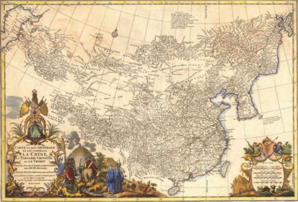
For students of
Chinese history, the date jumps out. This was the height of the great Qing
dynasty, specifically the year when the Qianlong Emperor ascended to power. He
presided over a military expansion west and north, but his death, in 1799, is
associated with the period of decline that followed.
And then there are
the boundaries. The 1735 d’Anville map shows “China proper” as a landmass
separate from areas like Xinjiang, Tibet, Mongolia and Manchuria. The island of
Hainan is drawn in a different color, as is Taiwan. This depiction is utterly
at odds with how history is taught here.
Chinese students
learn that these areas are inalienable
parts of China, and that they have been for a long, long time. One netizen described the map as a “slap”
from Merkel. “We always say some regions are inalienable parts of China since
ancient times, but Merkel told us that even in 18th century those regions still
did not belong to China.”
Another reasoned that
it was the mapmakers, not Chancellor Merkel, who messed things up. “Merkel has
no special connotation,” they wrote.
“At that time German priests [sic] were not allowed to travel in such areas.”
To complicate the
matter, at least two different versions of the map have been circulating
online. State news wire Xinhua seems to have published
an entirely
different version of the map, prompting an entirely different set of
theories.
Tibetan activist and
blogger Tsering
Woeser spotted the difference and pointed it out on her Facebook page. To
express her dismay at the deception, she used a Chinese idiom that might be
translated as “they are so good at perpetrating fraud!” More literally, the
phrase means “to steal the beams and pillars and replace them with rotten
timber.”
As we shall further
see on a T-shirt example, Historical maps are a sensitive business in China.
Every schoolchild in
China learns that Tibet,
Xinjiang,
Taiwan,
and the Diaoyu
Islands have been "inalienable parts of China since ancient
times." The d’Anville map, at least visually,
is a rejection of that narrative. Unsurprisingly, China’s official media
outlets don’t seem to have appreciated Merkel’s gift. The People’s Daily, which
has given meticulous accounts of Xi’s European tour, elided any coverage
of the offending map. More curiously, when news of the map’s presentation
reached the Chinese heartland, it had somehow morphed into a completely
different one. A map published
in many Chinese-language media reports about Merkel’s gift-giving shows the
Chinese empire at its territorial zenith, including Tibet, Xinjiang, Mongolia,
and large swaths of Siberia. This larger
map was the handiwork of British mapmaker John Dower, published in 1844 by
Henry Teesdale & Co. in London, and was
certainly not the gift from Merkel to Xi. But this mistake was not noted or explained in Chinese
reports.
.jpg)
Fast forward May 2018
when a picture of the T-shirt was posted
on the Chinese social media network, Weibo, generating hundreds of complaints.
The offending T-shirt
showed a map of China without including Taiwan, the self-ruled island that
Beijing says is an integral part of the country. It also failed to show what
China calls “Southern Tibet”, a huge
swath of territory it claims in the northeast Indian state of Arunachal
Pradesh, and failed to draw a line
around China's territorial claims in the South China Sea.
Within hours, Gap posted
a statement on the Chinese microblogging site Weibo in which it said it was
“extremely sorry” for the shirt’s “erroneous” design. Photos of the shirt that
circulated on Weibo had been taken at an outlet store in Canada, according to
the accompanying post. Gap, in its apology, said it was investigating what went
wrong with the shirt and thanked customers and the government for their
“attention and support.”
But Gap was far from
the only company to have found itself in trouble for failing to recognize
China’s territorial claims. In January that same year the Marriott
International hotel chain, which had more than 600 properties in Asia last
year, apologized
for listing Tibet and Taiwan as separate countries on a customer survey.
Beijing has been quick to quash any suggestion that Tibet, a region
of China, and Taiwan, a self-ruled
democratic island, are independent from the country.
Also in February, the
German automaker Daimler apologized after its Mercedes-Benz brand used a quote from
the Dalai Lama in a social media post. Many people in China view the Dalai
Lama and his fellow Tibetan Buddhist exiles as dangerous separatists. The
Daimler post was deleted.
Also the following
year MAC, the cosmetics brand owned by Estée Lauder, had to apologize after an
email sent to customers in the United States failed to include Taiwan on a
Women's Day promotional email campaign to US customers, saying it will resend a
corrected version as soon as possible.
In February 2019 the
Chinese government even issued specific rules covering the printing within
China of maps in books or magazines intended for sale in overseas markets. Each
map would require permission from provincial officials and none would be allowed
to be distributed within the country. The possibility that a Chinese citizen
might see a map showing an unauthorized version of China’s territorial claims
was perceived as such a threat to national security that it justified the
involvement of the ‘National Work Group for Combating Pornography and Illegal
Publications’, according to the regulations.1 To prove the point, in March 2019
the authorities in the port city of Qingdao destroyed 29,000 English-language
maps destined for export because they showed Taiwan as a separate country.2
China is far from
being the only country with concerns about its borders. What is striking,
however, is the extent to which anxiety about those borders has become a
national neurosis.
Government statements
explicitly connected the mapping laws and regulations of 2017 and 2019 to the
state’s ‘patriotic education’ education’ campaign. Part of their purpose was to
guide the teaching of schoolchildren in the correct view of the country. Messages
from the national leadership obsessively remind the population that the only
way to be a Chinese patriot is to fervently seek the ‘return’ of Taiwan to
control by the mainland; to insist that China is the rightful owner of every
rock and reef in the South China Sea; (as pointed out by me in 2012) demand that Japan hand over the Diaoyu/Senkaku islands,
and insist on maximalist claims in the Himalayas. The official media constantly
remind citizens of the state’s territorial claims, exhort them to personally
identify with those claims, and nurture feelings of hurt and shame towards
unresolved border disputes. Paranoia about national boundaries in China is not
merely an obsession of online gamers or Weibo patriots; it is central to the
state itself. The speeches of Xi Jinping made clear that his vision of national
rejuvenation can only be complete when all the territory claimed by China is
under Beijing’s control.
The construction of today's China
But the story of how certain
territories came to be regarded as ‘rightfully’ Chinese while others did not is
far from simple. During the twentieth century, some areas that were held to be
‘natural’ parts of the country, such as Outer Mongolia, were let go while
others that had been abandoned, notably Taiwan, were reclaimed. When the Qing
Empire collapsed in 1911, most of its borders were more imaginary than real.
Except in a few places, where Russian, French or British empires had forced
them to be demarcated, they had never been formally defined. In the decades
after the revolution, the national elite in Beijing had to ‘fix’ a national
territory for the first time. This was a process that had to take place on the
ground but also in the national imagination. Maps had to be drawn but, just as
importantly, the world-view expressed on those maps had to be inculcated in the
minds of the people. Anxiety about the vulnerability of those borders was
deliberately generated, right from the beginning. There were fears of foreign
threats but there were also expansionist dreams and political calculations.
And while earlier
examples have been quoted in the excellent 2006 published "Empire at the
Margins" by Pamela Kyle Crossley (Editor), Helen F. Siu (Editor), Donald
S. Sutton (Editor) generally speaking the story of the invention of modern
China’s territory – and its territorial anxieties –can be said to have its
beginnings a century ago, in the aftermath of war and with the arrival of the
Western science of geography. It ends with the rediscovery of Taiwan, its
reconnection with the mainland, and then its separation.
The last major piece
of territory to be formally renounced by the Qing court the Treaty of
Shimonoseki (Japanese:
下関条約, also known as Treaty of Bakan (馬關條約; Mǎguān Tiáoyuē)
was signed away on 17 April 1895. The treaty that Li Hongzhang
agreed in the Japanese port of Shimonoseki ceded Taiwan, and
the Pescadore Islands off its coast, ‘to Japan in
perpetuity and full sovereignty’. Just over a month later, the acting governor
of the island, a mainlander, and a few other officials and merchants declared
independence in the name of the ‘Taiwan Republic’ rather than submit to
Japanese rule. They hoped to elicit support from Britain and France but the
Europeans saw no advantage in intervening and the Republic collapsed just
eleven days after being declared. Resistance, nonetheless, continued. It took a
further five months for Japanese forces to occupy all the cities and a further
five years before the last vestiges of banditry were completely crushed.3
Throughout this long
campaign, the Qing court declined to offer any support to its former subjects
in its former province. In fact, material support for the rebel Republic was
explicitly banned by a court edict in May 1895.4 The fate of Taiwan was simply
not important enough to Beijing to risk further conflict with Japan. Half a
century after the first ‘Opium War’, the Qing court had been forced to accept
the binding nature of international treaties. It had signed away its rights to
the territory and that was the end of it. Taiwan’s fate did not become a cause
célèbre, however. While the sundering of the island from the body of the
great-state was a major blow to the prestige of the court, it barely disturbed
the general population.
The mainland’s
relationship with Taiwan in 1895 could be described as, at best,
‘semi-detached’. Even after its partial annexation in 1684, the Qing had
treated the island as a dangerous frontier, notable mainly for its wild
aborigines and deadly diseases. The court only declared it to be a province 200
years later, in 1885, after the war with France. Taiwan remained a province for
just a single decade before it was ceded to Japan at Shimonoseki.5
In the aftermath of
the treaty-signing, Qing officials almost entirely ignored developments in
Taiwan. The island was lost, in the same way that other pieces of territory
signed away by other treaties had been lost. In 1858 the Qing had ceded 500,000
square kilometers of land north of the Amur River to Russia through the Treaty
of Aigun.6 They had then been forced, through other ‘unequal treaties’, to
allow European powers to establish micro-colonies all around the coast. Taiwan
appeared to have gone the same way; there was no feasible way of wresting it
back from Japan’s clutches. The 2 million or so Qing subjects on the island,
mostly speakers of the Hokkien and Cantonese
topolects, along with the aboriginal population became colonial subjects of
Japan.
Surprisingly,
perhaps, the same insouciance about Taiwan’s fate also characterized the
revolutionary movement. Sun Yat-sen and his comrades made no demands for the
return of the island to Qing control. At no point, so far as we know, did Sun
concern himself with the resistance to Japanese rule, even though it continued
to smolder. For Sun, Japanese-controlled Taiwan was more important as a base
from which to overthrow the Qing Dynasty than as a future part of the Republic.
We can see this in his behavior during 1900. That year, Sun left Japan and
traveled around Southeast Asia seeking support for a planned uprising in
Guangdong province. He was disappointed: neither the established reformists nor
local community leaders took him seriously. Instead, when Sun returned to
Nagasaki he became part of a Japanese plot to seize the port of Amoy
(modern-day Xiamen). Under Tokyo’s patronage, Sun based himself in Taiwan and
ordered his revolutionary forces to mass around their main support base in
Guangzhou. But, in a typically rash move, Sun changed the plan at the last
minute, diverting the fighters to Amoy, where he intended to join them
accompanied by a shipment of Japanese weapons. The Japanese, however, had
become concerned about provoking a Russian reaction and backed out of the
entire scheme. Sun’s rebel force found itself isolated and outgunned and was
destroyed.7
Despite the betrayal
in Amoy, Sun continued to regard the Japanese government as his main sponsor,
and the revolutionary movement continued to ignore the issue of Taiwan. The
reformists had little interest in the island, either. When a leading Taiwanese activist,
Lin Xiantang, met Liang Qichao in Japan in 1907,
Liang advised him not to sacrifice lives in opposing Japanese rule since the
mainland would not be able to help. Since neither could speak the other’s
topolect, Liang had to communicate with Lin through ‘brush talk.’ This only
made Liang’s message more poignant: ‘(We were) originally of the same root, but
are now of different countries.’8 The Qing court, the revolutionaries, and the
reformists all took the same view: Taiwan had been ceded by treaty and lost to
China. It seems remarkable, given the passion that the island’s political
status generates today, but the island virtually disappeared from political
discussions in the decade before the revolution of 1911/12. Even after the
revolution, when Sun had no more need for Japanese support, he and his
supporters continued to ignore Taiwan's fate.
While some
revolutionaries were prepared to cede the peripheral territories of the Qing
Great-State in order to create a pure ‘Han’ state in the heartland, Sun and
Liang shared a determination to ensure the Republic inherited all the territory
of the former empire. The ‘non-Chinese’ Chinese’
areas (Manchuria, Mongolia, Tibet, and Xinjiang) made up more than half of its
territory and contained vital natural resources. But in order to express their
desire to defend the national territory, Sun, Liang, and their supporters had
to create new words with which to describe it.
There were several
words for ‘place’ in Chinese, but none that equated to the territory, with its
connotations of ownership and sovereignty. The traditional term was jiangyu, which literally meant the imperial realm's
boundary (jiang) (yu). In dynastic times the yu stretched as far as the emperor’s authority and so, in
theory at least, could have included tributary and vassal states.9 Its meaning
was vague and certainly did not imply the existence of a defined border.
A new word for
‘territory’ came into Chinese from Japanese, specifically from a Japanese
translation of a text by the British Social-Darwinist Herbert Spencer. In his
1883 translation of Spencer’s Political Institutions, Sadashiro
Hamano chose the two kanji characters ryo-do –
literally ‘governed-land’ – as equivalents for ‘territory.’ As president of
Keio University, Hamano was an authoritative figure, and his translation soon
spread into general use. Fifteen years later, when Liang Qichao translated
Tokai Sanshi’s nationalistic novel Strange Encounters with Beautiful Women from
Japanese into Chinese for his newspaper Qingyibao, he
used the same characters.10 In classical Chinese, they are pronounced ling-tu but have the same meaning – ‘governed-land.’ Lingtu, therefore, carries the clear meaning of a sovereign
country, enclosed within a defined border.
From there, the word
was picked up by one of Sun Yat-sen’s followers, Hu Hanmin.
One of Hu’s roles in the revolutionary Tongmenghui
movement was to provide the theoretical justifications for Sun’s policies.11Hu
expounded on the political implications of lingtu in
a lengthy article (‘Anti-foreign Sentiments and International Law’ – Paiwai yu guojifa),
printed over several editions of the revolutionaries’ newspaper Minbao during 1904 and 1905. He was arguing that
territorial sovereignty – lingtu zhuquan
– was the foundation of international law and that, logically, the
revolutionaries needed to oppose the ‘unequal treaties’ demanded by foreign
powers. Hu’s ideas – and his new words – were largely based on a 1,000-page
book by a Japanese legal scholar, Takahashi Sakue,
entitled International Law in Peace Time, published the year before.
Takahashi’s tome was, in turn, a summary of several Western works printed over
a previous couple of decades.12 In other words, the revolutionary movement’s
new-found territorial passions were the direct descendants of late
nineteenth-century European nationalisms.
The progeny of this
Euro-Asian ancestry emerged in the Republic of China’s constitutional debates a
decade later. The ‘Provisional Constitution’ written by Sun Yat-sen’s allies
immediately after the revolution and approved by the freshly-installed president,
Yuan Shikai, on 11 March 1912, set out in relatively
precise detail what it believed the territory of the Republic should be. In
effect, it said that the new state inherited the boundaries of the Qing
Great-State as they stood when the revolution broke out. Article 3 stated
simply that ‘The territory of the Chinese Republic consists of 22 provinces,
Inner and Outer Mongolia, and Tibet.’13 The choice of ‘22’ provinces was highly
significant since Taiwan was the twenty-third. Given that the constitution text
was still laying claim to Outer Mongolia, despite its declaration of
independence three months earlier, Tibet despite the ongoing insurrection
there, and Xinjiang despite its de facto independence at the time, this seems
to be clear proof that the Republic had formally abandoned any claim to Taiwan.
However, in May 1914,
when Yuan Shikai, the former Qing general who had
forced Sun Yat-sen from office in 1912, imposed a new ‘Constitutional Compact’
on the country, the national territory's definition was changed. Article 3
became the apparently tautological ‘The territory [lingtu]
of the Chinese Republic remains the same as the domain [jiangyu]
of the former empire.’14 New words notwithstanding, the 1914 constitutional
definition of territory merely begged a further question about the exact extent
of the former empire's domain.
After Yuan died in
1916, the Compact was suspended, and the first constitution was reinstated. So,
from 29 June 1916, the national territory definition reverted to the ‘22
provinces, Inner and Outer Mongolia, Tibet and Xinjiang’. But seven years
later, the Republic returned to tautology. The constitution approved on 10
October 1923 replaced Article 3 with the words ‘The territory [guotu – literally ‘state land’] of the Republic of China is
based on its inherent domain [jiangyu].’15 Once
again, no definition of that territory or domain was provided. Eight years
after that, the new ‘Provisional Constitution’ promulgated by the Guomindang
government of Chiang Kai-shek on 1 June 1931 struck a compromise. Article 1
combined vagueness and specificity by stating, ‘The territory [lingtu] of the Republic of China consists of the various
provinces and Mongolia and Tibet,’ 16 but the number of provinces was left
undefined. By 1931 Qinghai had been forcibly reincorporated into the state and
given the status of a province. Mongolia and Tibet had been independent of the
Republic for almost two decades by this time, but Chiang still claimed them
nonetheless. Notably, Taiwan was still not a consideration. The last Republican
constitution promulgated before the civil war doesn’t even attempt to define
the national territory. The version approved on 25 December 1946 merely says,
in Article 4, ‘The the territory of the Republic of
China according to its existing national boundaries shall not be altered except
by resolution of the National Assembly.’17
This constitutional
back-and-forth demonstrates that there was considerable difficulty in deciding
exactly where the country’s boundaries should be drawn throughout this period
and even beyond. Some fundamental questions needed to be answered first, chiefly:
where were the boundaries of the Qing Great-State that the Republic had
ostensibly inherited in 1912? The Nationalist modernizers thought there was a
simple answer to that question based on a view of borders they had acquired
through contact with foreign powers and experts. The reality was far from
simple.
The Qing Great-State
had constructed, in effect, a multi-ethnic federation in which five ‘script
regions’ – Chinese, Manchu, Mongol, Tibetan and Turkic – were ruled separately
through different structures and according to different rules. It was an approach
known in Chinese as jimi – loose rein – although Qing
government methods would have varied depending on the peoples they were dealing
with.18 The mission of revolutionaries like Sun Yat-sen was to create a single
unitary nation-state ruled from the center through a single set of structures
and rules. Yuan Shikai, who had risen to power
through the old imperial system, was far more familiar with the traditional
techniques of a rule than with the new ideas of the Western-educated
nationalists. His conservative instincts led him towards a more ‘fuzzy’
definition of the state, while the modernisers’
search for clarity on the national question led them to seek something more
precise. But the more they tried to impose unity on strong local rulers, the
more the warlords broke away, causing the fragmentation of the very state they
were trying to unify.
The Qing Empire had
only formally defined its borders in places where it had been forced to do so
by other powers: from the 1689 Treaty of Nerchinsk, which drew a line with
Russia in the northeast, through to the 1894 Convention with Great Britain,
partially demarcating the boundary with Burma in the southwest.19 Elsewhere,
the situation was far from clear: how far did the boundary of the realm – the jiangyu – stretch? At the end of the Qianlong Emperor’s
reign in 1796, the Qing court accepted tribute from thirteen rulers whose
territory lay even further west than Xinjiang province and from a Gurkha ruler
beyond Tibet even though none were under Qing rule.20 So did the jiangyu include them? On the other hand, even within the
Qing domain, the court exerted control over remote and thinly populated regions
through local rulers whose own control, and loyalty were not absolute. The Kham
area of eastern Tibet, for example, had long been ruled by autonomous
chieftains who were only nominally subordinate to the rulers based in Lhasa
and, through them, even more nominally to the emperor in Beijing.21 Although
Qing officials were based in a few strategic places, wide areas were left
unsupervised. A military campaign to impose central rule on Kham in 1745/6 was
a costly failure. ‘Loose rein’ rule was reinstated.
As a result, we
should see the Qing’s efforts to control central Asia in the nineteenth century
not so much as attempts to defend ‘their’ territory from the predations of
outsiders but as moves in constant competition (a ‘Great Game’) for territory
and influence between three empires: the Qing from the east, the Russian from
the north and west and the British from India in the south. Throughout the
nineteenth and early twentieth centuries, all three were battling for the
support of, or domination over, dozens of local rulers, warlords and other
kinds of leaders – spiritual and temporal. We can see one effect of this
increased competition in the change of meaning of the Chinese word Bian Jiang(便江镇). The Australia-based historian James Leibold has
shown how it was used to refer to an intermediate zone between two states in
the eighteenth and early nineteenth centuries. During the later nineteenth
century, however, it came to mean the line of a defined border in certain
places.22
The Guomindang’s nationalist mission.
In the aftermath of
the 1900 uprising known in the west as the Boxer
Rebellion, the Qing government had been forced to pay compensation of 450
million taels of silver to the Western powers. The United States government had
demanded $25 million, a sum which even its own diplomats in Beijing regarded as
excessive – perhaps twice as much as the actual damage suffered by American
citizens and their government during the violence. Over the course of the
1900s, pressure rose on Theodore Roosevelt’s administration to do something to
alleviate the huge burden of debt imposed on the Qing government. By 1909 a
compromise emerged: the excess, around $11 million, was Coching Chu or Zhu Kezhen ( 竺可楨;
pinyin: Zhú Kězhēn).
In 1910, at the age
of twenty, Zhu arrived at the University of Illinois to study agronomy. But he
hadn’t traveled to the United States to become a better farmer. He wanted to be
a scientist and, after receiving his degree, enrolled for a Ph.D. in meteorology
at Harvard. There, his supervisor was Robert DeCourcy Ward, America’s first
professor of climatology. Ward’s views went much wider than the weather,
however. In 1894 he had co-founded the Immigration Restriction League, and his
academic opinions combined meteorology with eugenics: he believed that climate
determined civilization. He claimed that in the seasonality of the planet's
temperate zone ‘lies much of the secret—who can say how much of it?—of the
energy, ambition, self-reliance, industry, thrift, of the inhabitant’. By
contrast, in the tropics, the climate was enervating, and ‘voluntary progress
toward a higher civilization is not reasonably to be expected.’23 As a result
it was entirely justified, in Ward’s view, for white people from the temperate
zone to develop the tropical areas of the globe, even with slave labor if
necessary. He was particularly impressed with the ability of Chinese ‘coolie’
labor to work in all conditions. Zhu lapped up all these theories, gained his
Ph.D. and returned to China in 1919 to become the first professor of geography
at the Normal University of Wuchang, moving to Southeastern Normal University
in Nanjing the following year.24
At Nanjing, he passed
on these ideas to the second generation of Chinese geographers, the ones who
would devote their careers to helping build the new state. In the words of one
historian of this period, Zhihong Chen, ‘Ward’s influence was evident in Zhu’s
works.’25 The American professor’s environmental determinism gave a new
‘scientific’ basis to the prevailing Han racism of the time and helped set the
parameters for geography's emerging discipline. According to Zhu, China’s
temperate latitude had blessed its people (the Zhongguo-ren)
with intermediate skin color and an unusually strong ability to adapt to all
kinds of environments. In his reasoning,
People who are used
to tropical climates cannot bear winter in the temperate zone . . . Those who
are used to temperate climates cannot stand tropical or frigid weather . . .
But we Chinese are exceptional! No matter how hot or cold an environment is, there
are Chinese footprints. . . . [W]hen the Panama Canal was excavated, only our
Chinese people kept working tirelessly and efficiently when foreign workers
could not even work. This is why foreigners call the Chinese ‘the yellow
peril.’ This is also a ray of morning sunshine for us Chinese in the future!
Among Zhu’s many students at Nanjing during the 1920s was Zhang Qiyun (often spelt Chang Chi-yun).
Over the following three decades Zhang would personify the search for China’s
national territory. He would help define it, propagate it, survey it, advise
the government on securing it but then, ultimately, flee it. Over the course of
an academic and then political career, he would place his insights at the
service of the national struggle for survival. In the process, he bound his
fate, and that of his political masters, to Taiwan.26
Zhang Qiyun joined Zhu Kezhen’s
first-ever geography class in 1920. He graduated three years later and joined
the Commercial Press staff in Shanghai where the brother of one of his
classmates was an established editor.27 The editor was Chen Bulei
who would also go on to play a major role in nationalist politics. Together,
Zhang, Chen, and Zhu formed an influential clique at the intersection of
academia, journalism, and propaganda. Together, the trio brought geography into
the center of Chinese political thinking and put it at the service of the
Guomindang’s nationalist mission.
As it would be called
next, the' Nanjing decade' was a time of profound change in both the politics
and the Republic of China's educational systems. The Guomindang captured
Nanjing and Shanghai in March 1927, and within eighteen months, the party was
nominally in control of the whole country. With Chiang Kai-shek installed as
chairman, the Nationalist Government began to impose its vision of national
unity on the country: a vision that owed more to Sun Yat-sen’s ideas of a
homogenous Zhonghua minzu than to Yuan Shikai’s toleration of difference. The ideology of ‘the
nation of five races,’ which had guided the state since 1912, was dropped. On
29 December 1928, as a mark of intent, the national flag was formally changed
from the colored stripes of the ‘five races’, which had flown since the birth
of the Republic, to a red flag incorporating in the top left corner the Tongmenghui’s original ‘Blue Sky, White Sun’ flag favored
by Sun Yat-sen. It remains the flag of the Republic of China (on Taiwan) to
this day. This new nationalism determined the Republic’s entire approach to the
border question and the situation of minorities living in the frontier areas.
In the new
government's view, the frontier had to be ‘saved’ by making sure its
inhabitants became loyal citizens of the Republic. Although this was supposed
to be the era of ‘self-determination’ – US President Woodrow Wilson had
declared it to be so in 1918 – the Guomindang had no intention of offering such
a choice to the inhabitants of Tibet, Xinjiang, Mongolia, or Manchuria. In
their eyes, the right of self-determination was reserved for the Chinese nation
in its struggle against foreign powers. This was no mere academic debate but
rather a life-and-death struggle, since one of those powers, Japan, was already
deploying the ‘self-determination’ argument for its own imperial ends. Japanese
officials highlighted the ethnic differences within the former Qing Great-State
to argue that those groups had a right to self-determination and to secede from
the Han-dominated Republic. They claimed to be upholding this principle as
they, in effect, annexed Manchuria in 1931 and encouraged separatism in
Mongolia and Xinjiang.
Under these
circumstances, the Guomindang weaponized the study of history and geography. In
1928 the director of the Nanjing government’s Ministry of Propaganda, Dai Jitao
(who was simultaneously president of Zhongshan University in Guangzhou), called
for the establishment of geography departments at all the country’s major
universities, arguing that they would play a vital role in national defense.
The first one was established in 1929 at Zhongyang University, where Zhang was
already on the staff. Over the following eight years, geography departments
were established at nine other major universities. Former students of Zhu Kezhen staffed most of them.28The output of these
departments was dedicated to serving the state and its frontier mission. The
Chinese historian Ge Zhaoguang has described this
period in academia as ‘national salvation crushing enlightenment’ (jiuwang yadao qimeng).
Many experts who had spent the 1920s researching the differences between ethnic
groups and the contested history of the country’s frontiers either changed
their public views or went quiet during the late 1930s, as Japan's threat grew.
They included such
well-known geographers, historians, and anthropologists as Liu Yizheng, Gu Jiegang, and Fei
Xiaotong. They, and others, chose ‘national salvation’ over ‘enlightenment.’29
Up until 1927, school
education had been controlled by local elites and varied widely in content and
quality. Even before they had taken power across the whole country, the
Guomindang leadership had recognized the importance that education would play
in their efforts to construct the new nation. The party’s Fourth Plenum in
January 1928 declared that ‘education is indeed a life-or-death matter for
Chinese citizens’ and must play a central role in the party’s war on ‘erroneous
ideologies’ (such as communism).30 A few months later, in May 1928, just after
the establishment of the Guomindang’s ‘National Government’ in Nanjing, the
party convened the ‘First National Conference on Education.’ The conference
resolved to adopt a new national curriculum for schools based upon Sun
Yat-sen’s ‘Three Principles of the People’: Nationalism, Democracy and People’s
Livelihood. Within months, the GMD had captured Beijing and very quickly set
about imposing a new ‘temporary curriculum’ nationwide. From 1929 all schools
were expected to imbue their pupils with strong feelings of patriotism,
mobilized in particular through the teaching of history and geography.31 Pupils
were expected to study the various regions of the country, ‘in order to foster
the national spirit.’
A major contribution
to this patriotic education movement was the series of textbooks written by
Zhang Qiyun. In 1928 the Commercial Press published
one as Benguo Dili – ‘Our Geography.’ Its key message
was that China formed a natural unit despite its enormous size and variety.
Using his geographical training, Zhang divided up the country into twenty-three
‘natural’ regions based on their environments and the inhabitants’ ways of
life. He then compared them, telling pupils that, for example, the Yangtze Delta
was good for farming but had no minerals; Shanxi was rich in coal but too dry
for agriculture; Manchuria was forested while Mongolia was good for grazing,
and so on. He then told the young learners that this diversity was actually
proof of the need for national unity since each different part was an essential
part of a coherent whole.32
Yet the ‘whole’ that
Zhang portrayed in the textbook was a territory that, in reality, did not
exist. The book contained various maps of the country drawn on blank
backgrounds so that the rest of the world disappeared from view. The simple
black line marking the national boundary encompassed huge areas that were not
actually under the government's control: the independent states of Mongolia and
Tibet. Zhang portrayed them as a natural part of the Republic, nonetheless. How
reality would be reconciled with the map was not explained to the pupils.
Remarkably, given present-day politics, there was a significant omission:
Taiwan was not drawn in any of the textbook's national maps. It seems that, in
Zhang’s view, the ‘natural’ shape of the Republic was exactly the same as the
shape of the Qing Empire at its collapse in 1911. Mongolia was included; Taiwan
was not. The rocks and reefs of the South China Sea did not feature at all.
Zhang spent the next
four years writing the geography textbooks used in most Chinese schools during
the later 1920s and beyond. His memoirs show that Zhu was a strong influence on
their content. Then, after Chen Bulei became the
editor of the country’s third-largest circulation newspaper, Shangbao (‘Commercial News’), he commissioned Zhang to
write commentaries on geographical topics. In 1927, Zhang was appointed a
geography lecturer at Zhongyang (National Central) University in Nanjing on
Zhu's recommendation.
These were not
marginal ideas; Zhang’s Benguo Dili book had a huge
impact. Ten editions were printed before July 1930, a further seven after 1932,
and it was honored as one of the country’s three most important textbooks
of the time. It was far from being the only example. Dozens of geography textbooks
were printed during the 1920s and 1930s, and they all ignored Taiwan while
stressing the importance of Mongolia and Tibet. Zhang himself, in another
textbook he co-wrote in 1933, Waiguo Dili – ‘The
Geography of Foreign Countries’ – described the people of Taiwan as ‘orphans’
deserted by their birthmother, the Chinese nation Zhonghua minzu,
and abused by their stepmother, Japan.
Zhang, and the other
authors of these books, faced a problem that was both pedagogic and deeply
political. How could they persuade a child in a big coastal city, for example,
to feel any connection with a sheepherder in Xinjiang? Why should they even have
a connection? The general purpose of human geography was to explain how varying
environments had created groups with differing cultures. However, nationalism
required all these different groups to feel part of a single culture and loyal
to a single state. It was up to nationalist geographers to resolve the puzzle.
They found two main ways to do so. One group of textbook authors simply stated
that all Chinese citizens were the same: they were members of a single ‘yellow’
race and a single nation, and no further explanation was needed. However, a
second group acknowledged that different groups did exist but were nonetheless
united by something greater. Within this group, some authors made use of
‘yellow race’ ideas, some used the idea of a shared, civilizing Hua culture,
while others stressed the ‘naturalness’ of the country’s physical boundaries.
The textbook writers
argued that the answer to the ‘border question’ was to ‘civilize’ the
inhabitants. One, Ge Suicheng (who was employed by
the rival, but equally nationalistic, Zhonghua Publishing Company), found
himself facing the same dilemma as the Guomindang government. Both needed to
emphasize all ethnic groups' theoretical equality while simultaneously making a
case for their melding into a single Chinese nation based on ‘Han’ culture. In
Ge’s view, the study of geography should make the different peoples of the
state love their particular home areas but also connect them emotionally to the
wider national territory. But in the meantime, in the words of his textbook,
‘We should urgently promote the acculturation of the Mongols, Hui [Muslims] and
Tibetans so that they are not lured by the imperialists, [and we should] move
[Han] inhabitants to the border areas for colonization...’
Zhang Qiyun’s 1928 textbook was also deeply imprinted with racial
chauvinism. One part of the book’s message to its millions of young readers was
that the country was on a journey from barbarism to civilization and that the
wild frontier, where the minorities lived, needed to be tamed and developed.
The book included a table of various ethnic groups showing how assimilated they
were to the ‘main body’ (zhuti) of the Han. In a
description of the southwest Miao people, Zhang wrote, ‘They maintain the
customs of great antiquity and are totally incompatible with the Han people.
Eliminating their barbarism and changing their customs and habits is the
responsibility of the Han people.’ For Zhang, the Han provided the ‘norm’
against which the other groups needed to be measured in order to judge their
level of civilization: they had to be made ‘Han.’ He shared Zhu Kezhen’s opinion that climate was the determining factor in
the spread of civilization. In his 1933 textbook, he observed that in
southwestern Yunnan province, the native population lived in the hot and humid
lowlands while the Han people (Han-ren) lived on the cooler plateaus. On the
other hand, in the mountains of the northwest, the Han lived in the valleys
where it was warm while the natives lived at altitudes where it was colder. It
was only natural, therefore, that the ‘temperate-dwelling’ Han-ren, free of ‘degenerating’ environmental
influences, should exert their influence over the minorities – the tu-ren.35 Other
textbooks made the same point, stressing Sun Yat-sen’s arguments that the Han
made up 90 percent of the country’s population and that it was only natural
that the other groups would assimilate.36 A idea that, as pointed out by me in Jan. 2018 is very present also in Xi Jinping’s
repeated promise of “the great rejuvenation of the Chinese nation.”
These arguments can be
traced back to those made by Liang Qichao a
couple of decades before. Liang created a story of continuity: the expansion of
a civilized territory outwards from its cradle in the Yellow River valley.
The new geographers
tried to write the final chapter, its diffusion to the Republic's very edges.
They also borrowed from Liang the idea that certain rivers and mountain ranges
formed ‘natural’ boundaries to the state. This was the argument deployed by Ge Suicheng in his 1933 textbook and Lü
Simian (who worked at both the Commercial Press and Zhonghua Publishing). The
most poetic technique was simply to compare the shape of the imagined country
to that of begonia or mulberry leaf turned on its side. Tianjin's port became
the petiole of the leaf with a central ‘vein’ running west as a line of
symmetry all the way to Kashgar in Xinjiang and
beyond. The symmetry only made sense, of course, if Outer Mongolia and Tibet
were included and Taiwan was excluded. The historians Robert Culp and Peter Zarrow have documented many examples of other geography
textbooks that use different, sometimes contradictory arguments and analogies
to persuade students of the ‘naturalness’ of the Republic’s putative borders.
An ever-present theme
in these textbooks was the threat of foreigners eating away at the country’s
edges. It was reinforced through school lessons about territory ‘lost’ during
the previous century. Teachers could use a peculiarly Chinese form of nationalist
cartography – the ‘map of national humiliation.’ Dozens of such maps were
published by the Commercial Press, Zhonghua Publishing, and other companies
during the 1910s, 1920s, and 1930s, sometimes within textbooks and atlases and
sometimes as posters for display in classrooms and public buildings. They are
typically portrayed in bright colors, land ‘conceded’ to neighboring states
over the previous century.37 There was a clear political purpose behind the
making of these maps. They served to delegitimize the Qing Dynasty – by
demonstrating its failure to ‘defend the country’ and thereby legitimize the
revolution. But they also deliberately generated a sense of anxiety about the
nation’s border's vulnerability to promote loyalty to the new Republic. It seemed
to work with a young Mao Zedong. He later told the American journalist Edgar
Snow that hearing about national humiliation made him an activist.38 It wasn’t
just Mao. This was the birth of the national territorial neurosis.
The geographers took
the nationalist idea of ‘territory’ – lingtu – and
projected it back to the time of ‘domain’ – jiangyu –
when there were few fixed borders. A map of national humiliation in Ge Suicheng’s 1933 textbook showed vast areas of central Asia,
Siberia, and the island of Sakhalin as territory ‘lost’ to Russia. The map may
have displayed different areas as ‘territory,’ ‘tribute states,’ or ‘vassal
states’ but all were categorized as inherently ‘Chinese,’ nonetheless. The idea
that at the time they were ‘lost,’ these territories might have been contested
areas with no clear allegiance to any particular empire was not part of the
lesson. They were presented simply as ‘Chinese’ lands that had been stolen. Ge Suicheng called on the young citizens reading his textbook
to do what they could to recover all this lost territory. Did this mean this
‘lost’ territory should be included within the state's rightful boundaries, or
not? Was the shape of the country at that time natural or not? These questions
were not even posed in the textbook, let alone answered. What was important for
authors like Ge was to encourage students to feel the sense of loss, a
collective sense of ‘national humiliation,’ and thereby develop a patriotic
attachment to the country. Anxiety about the territorial loss was a fundamental
part of the nationalist education project right from the beginning. The anxiety
was compounded because no one, not even the geographers, knew where the borders
actually were. The historian Diana Lary has shown how, in the southwestern
province of Guangxi, the border's exact line was almost irrelevant. Although it
had been formally agreed with Indochina'se French
colonial rulers in 1894, as far as the Republican officials were concerned, the
border was just somewhere in the mountains: high, remote, and difficult to
reach. The state had generally managed minority groups in southern highlands
through a system known as tusi, in which local
leaders were held responsible for their people's actions.39 Borders were largely
irrelevant. So long as they didn’t trouble the authorities, the mountain peoples were generally left alone.
In Lary’s words, ‘The Chinese world stopped well before the borderlands.’40
(Things would change. This is the same border that thousands of Chinese and
Vietnamese soldiers died fighting over in 1979.)
In 1928, the original
geographer Zhu Kezhen declared that Chinese
cartography was about a century behind its European counterpart. At the time,
most of the publicly available maps were still based on 200-year-old surveys
from the early Qing period. In January 1930, the government issued an official
‘Inspection Regulations for Land and Water Maps’ (Shuilu
ditu shencha tiaoli), instructing the Ministry of Internal Affairs, the
Foreign Ministry, the Marine Ministry, the Ministry of Education, and the
Committee of Mongolia and Tibet to work together to regularise
the country’s cartography. Nothing actually happened, however, until 7 June
1933, when the official ‘Land and Water Maps Review
Committee’ held its first meeting.
In the absence of
government action, a few academics and private organisations
tried to fill the gap. In 1930 senior staff at the influential Shanghai-based
newspaper Shenbao discussed organising
an expedition to the frontier to celebrate the paper’s sixtieth anniversary.
They asked two well-known members of the National Geological Survey of China,
Ding Wenjiang and Weng Wenhao, and a cartographer,
Zeng Shiying, to lead the effort. However, during the
planning meeting, it became clear that no one knew where the actual frontier
was. Ding told the gathering: ‘If we want to organize a successful research
trip of China’s frontiers, we first need a map. . . . No one has yet drawn a
complete and accurate map of the entire country. Before we organize the trip,
we should, therefore, first work on sketching a map of China.’ The anniversary
plans, therefore evolved into a project to publish a new national atlas. The
result was the publication by the newspaper of New Maps of the Chinese Republic
(Zhonghua minguo xinditu)
in 1934.
The atlas was well
produced and a best-seller. In the absence of any government-produced
equivalent, it became the national standard until well into the
1950s. However, its depiction of the frontier areas was, in most places, a work
of fiction. As was now standard in Chinese maps of this time, Tibet and Outer
Mongolia were depicted as integral parts of the state while Taiwan was not. The
neat black dashed-and-dotted line that ran around the Republic was more an
expression of desire than reality. As Owen Lattimore, the American scholar who
explored these areas in the 1920s and 1930s, wrote, ‘The linear frontier as it
is conventionally indicated on a map always proves, when studied on the ground,
to be a zone rather than a line.’ In the more recent words of another American
historian, James Millward, the frontier was a
process, not a place. Wide areas were open to disagreement and conflict.
In December 1928, the
government had ordered every province and county to compile a new ‘gazetteer’ –
fangzhi – of the area under its administration.
Gazetteers were an established tool of local government going back centuries,
but this new incarnation was intended to be drawn up according to modern
geographic practice:
produced with the
help of newly trained experts using accurate maps and statistics. There was to
be a particular focus on ‘frontier’ areas, where the government’s control was
weak.
This focus on
gazetteers chimed with Zhang Qiyun. He had just
co-founded a new academic journal, Dili Zazhi
(‘Geography Review’), to promote human geography in secondary schools. In early
1929, Zhang authored an article in Dili Zazhi arguing
that this new generation of gazetteers would help to foster ‘homeland feeling’
among the people. This, in his view, would be a positive development because
‘Homeland feeling is the basis for nationalism.’ In another edition of Dili Zazhi he called for the middle school geography curriculum
to be based on Sun Yat-sen’s Principle of Nationalism. He became increasingly
influential: his ‘Tentative Suggestions for Middle School Geography Course
Standards,’ published later in 1929, were adopted by the Ministry of Education
as the basis of the new curriculum. They had two main components: explaining
the natural conditions and social customs of every place in the country in
order to foster the nationalist spirit, and explaining the
international situation in which the country found itself. As a result, he
argued, ‘patriotism and the desire to save the nation will automatically grow’.
Promoting nationalism became the purpose of Zhang’s geographical
activities.
These contributions
brought Zhang’s work to the attention of senior figures in the Guomindang. In
December 1930 he was invited to join the party by its executive committee,
probably at the suggestion of his former editor, Chen Bulei.
Chen had joined the Guomindang in February 1927, and had swiftly become the
party’s leading propagandist. Zhang declined the invitation, but on 1 November
1932 he became one of the forty or so founding members of the government’s
‘National Defence PlanningCommission’,
created in response to the Japanese invasion of Manchuria in September 1931,
and also to counter increasing unrest in Xinjiang. Its primary purpose was to
advise on strategic issues such as military preparedness and the economy. Zhang
was given two roles on the Commission, evidence of geographers' dual roles
during the period. Initially, he was placed in charge of preparing
the country’s geography textbooks, with a mission to inculcate the youth with
the right values for national survival. Under Zhang, the geography curriculum
became more explicit, emphasising the need to protect
China’s territorial integrity. Then, in September 1934, Zhang was deployed as
‘head of geography’ for a two-year-long investigation of the country’s
northwestern frontier: the provinces of Shaanxi, Gansu, Ningxia, and Qinghai.41
It was an academic
mission with strategic importance. With Tibet having achieved de facto
independence and Xinjiang ruled by warlords, the Nanjing government needed to
know whether the surrounding provinces might also try to break away. The
geographers were also tasked with drafting a plan for the region's economic
development to connect it more closely to the heartland. The whole enterprise
was supposed to be a low-profile operation, but in December 1934, while
researching Gansu, Zhang revealed himself to be more academically than a
politician. He delivered a speech about the National Defence
Planning Commission's work, stressing the importance of the region’s economic
development for national security. In it he compared his own work to that of a
Ming Dynasty scholar, Gu Yanwu, who, three centuries
earlier, had prepared a document, Tianxia junguo libingshu (‘On the
Strengths and Weaknesses of Various Places of All Under Heaven’) to help secure
the northwestern frontier from invasion.42
This led to a deluge
of newspaper coverage of supposed to be secret activities, and Zhang found
himself in considerable trouble.
Four months later,
the Commission was reorganised into the ‘National
Resources Commission’ and placed under the government’s Military Committee, and
Zhang was sent back to academia. It was not long, however, before the
Guomindang geography network had him rehabilitated. His old friend Chen Bulei was, by then, working as Chiang Kai-shek’s
chief-of-staff. In April 1936, Chen lobbied Chiang to appoint Zhu Kezhen as head of Zhejiang University in Hangzhou. The week
after Zhu took up the post, he offered Zhang the position of head of
the university’s Department of History and Geography. Perhaps in gratitude,
Zhang finally agreed to join the Guomindang in July 1938, on Chen Bulei’s recommendation. For the next ten years, he would
combine his political career with his academic one while remaining a senior
figure at Zhejiang University.
Meanwhile, the
national situation was becoming ever more critical. Japan had invaded ‘China
proper’ in July 1937, and by the end of the year, its forces had captured
Beijing, Shanghai, and Nanjing. As the crisis grew deeper, Chiang Kai-shek
urged the use of geography and history as tools to spread Guomindang ideology
among the country’s youth. On 28 August 1938, Chiang gave a speech to the first
graduation ceremony for the Central Training Corps (a paramilitary organisation intended to indoctrinate army officers and
senior civil servants) in the city of Hankou, in which he told his
audience:
If our people do not
know our national history's glory, how can they fully perceive our humiliation
today? If they are not familiar with the geography of our nation, how can they
find the resolve to restore our lost territory? From today forward,
we must not tread this disastrous path any longer: we must absolutely give
special emphasis to history and geography education, to stimulate the citizens’
patriotic spirit to defend the country, and launch our people’s brilliant and
dazzling new destiny!
As a result, the curricula
of universities, and then middle and high schools, were revised to include more
history and geography, ‘to stimulate students’ determination and resolve to
rejuvenate our national people’.
In December 1939,
with Japanese forces advancing south and east, Zhang was invited to talks with
Chiang about evacuating Zhejiang University to a safer location. However, it
seems the two didn’t actually meet until over a year later. On 15 March 1941,
they had dinner in Chongqing, along with Chen Bulei.
According to their diaries, the group talked about ‘history and geography
education . . . as well as frontier issues’. The geographer and the
generalissimo struck up a strong friendship: they came from the same hometown,
and Chiang described Zhang in his diary as ‘lovely.’ For Zhang, the
main result was a grant of $50,000 to establish a new academic journal, Sixiang yu shidai
(‘Ideas and Times’). After this, Zhang became, in effect, Chiang Kai-shek’s
geopolitical adviser. In 1942 he published a book on ‘The International
Development of China’ and another on ‘The Northeastern Problem’ (referring to
Manchuria's Japanese occupation). During 1942 and 1943, he wrote a series of
articles on ‘The Military History of China’ for the journal of the ‘Society of
Contemporary Thought,’ expounding on the importance of geographical
circumstances to military success. Then, in June 1943 and on Zhu’s
recommendation, Zhang was sent to the US as part of an academic delegation invited
by the Department of State. His original six-month stay was extended until the
autumn of 1945. His publications there included one entitled ‘Climate and Man
in China’ that harked back to Zhu Kezhen’s original
studies decades before, and the first pamphlet for a newly established think
tank in New York, the Sino-International Economic Research Center, on ‘The
Natural Natural Resources of China.’ He
became a key figure in explaining China's geography to American officials while
also offering ideas to the Guomindang government on future policy.
The birth of the idea that
Taiwan is part of China
The Japanese invasion
had, unsurprisingly, forced Chiang Kai-shek to pay more attention to
geopolitics. During the early part of 1938, the Japanese started to occupy the
area between Beijing and Nanjing, and on 25 March they attempted to seize the
crucial transport hub of Tai’erzhuang, about halfway
between the northern and southern capitals. The battle happened to coincide
with an Extraordinary National Congress of the Guomindang, called by Chiang
Kai-shek to approve his de facto military control of the government. On 1
April, the congress did so, appointing him ‘director-general’ of the party. As
the fighting raged in Tai’erzhuang, Hankou's meeting
discussed the government’s foreign policy and handling of the war.43 In the
speeches and resolutions we see the emergence of Chiang’s geopolitical ideas.
In his speech on ‘The Anti-Japanese Resistance War and the Future of Our
Party’, Chiang argued, ‘We must enable Korea and Taiwan to restore their
independence and freedom, and enable them to solidify the national defense of
the Republic of China and consolidate the base for peace in East Asia.’
Significantly, although he noted that Taiwan had been part of China’s sovereign
territory (lingtu) in the past, he did not call for
either territory to be incorporated into China.44 What was important was the
two territories’ strategic position and their potential role as buffer states
on the country’s frontier.
In retrospect, what
is remarkable is how uncontroversial this was at the time. The Communist Party
had long supported independence for Taiwan, rather than reincorporation into
China. At its sixth congress in 1928, the party had recognized the Taiwanese as
a separate nationality. In November 1938 the party plenum resolved to ‘build an
anti-Japanese united front between the Chinese and the Korean, Taiwanese and
other peoples’, implicitly drawing a distinction between Taiwanese and Chinese.
At this time, in the Communist view, the Taiwanese were a separate minzu.45
This continued into the early 1940s with articles by both Zhou Enlai, in July
1941, and Marshal Zhu De, in November 1941, describing the future liberated
Taiwan as a separate nation-state. Even when the Communist Party declared war
on Japan in December 1941, its announcement listed Taiwan's people separately
from the Chinese.46
This view of Taiwan’s
separateness formed a consensus in Chinese politics at least until 1942. Three
things seem to have changed the situation. Firstly, the United States entered
the war, in December 1941, and it became possible to imagine Japan's defeat It
was only then that the Guomindang government formally declared war on Japan and
unilaterally renounced the Treaty of Shimonoseki. As
a result, Chiang’s thoughts turned to post-war geopolitics. Secondly, Chiang
was looking for ways to divert Japanese war efforts by promoting unrest in
areas under its control, such as Taiwan.47 And thirdly, a tiny number of
Taiwanese, who had fled Japanese colonialism for exile on the mainland, were
actively lobbying the Guomindang to think of Taiwan as part of China.
Dozens of small
Taiwanese exile organisations were formed in China
during the 1920s and 1930s, but they only began to unite and gain political
influence after starting the war with Japan. Being able to speak Japanese made
these activists very useful in intelligence and propaganda work, which gave them
access to military leadership. Many of them had also been trained in the
Japanese's latest medical methods and provided hospital services behind the
front lines. One doctor, Weng Junming, who had joined Sun Yat-sen’s Tongmenghui in 1912 as a nineteen-year-old student, became
a key figure. In September 1940, following lobbying by Weng Junming, the
Guomindang formed a ‘Taiwan Party Headquarters Preparatory Committee’ and put
Weng in charge. In February 1941 an alliance of several small Taiwanese groups
came together to create the Taiwan Revolutionary League which, in June 1942,
was formally recognised by the Guomindang.
It was at this moment
that the Guomindang’s discussion of Taiwan changed radically. In mid-1942 it
began to use the term retrocession (guangfu),
a word with particular nationalistic significance. Guangfu had been used during
the Tang Dynasty (618–906) to describe the regaining of control over land
previously conquered by foreigners. Comparing themselves to the Tang Dynasty
gave the Guomindang a useful propaganda boost during the dark times of war with
Japan and increasing hostility with the Communist Party. However, it is
interesting to note that the party felt it had to make a case for guangfu – it was by no means a logical step. Research by
the historian Steve Phillips shows that they did so in several ways: by
appealing to ideas of racial solidarity (that Taiwanese are of the Han
bloodline), historical precedent (the two centuries of rule by the Qing), the
illegitimacy of the Treaty of Shimonoseki and the assertion that guangfu was something that the Taiwanese population wanted.
However, it seems
from Chiang’s writings that his own desire to incorporate Taiwan into the
Republic was primarily driven by geopolitics. In November 1942, he began
drafting his post-war manifesto, the book-length China’s Destiny (Zhongguo zhi mingyun),
with the help of ghostwriters, of whom the most important was Chen Bulei. The text also shows the strong influence of
geographers. Zhang Qiyun had been personal friends
with Chiang for about two years by this stage and did not leave for the United
States until June 1943, three months after the book had been published. China’s
Destiny talks about the country forming ‘a self-contained unit’ and ‘each
region [having] its own particular soil and natural resources’ and with a
‘division of labor. . . largely determined by their physical conditions’. The
echoes of Zhang’s earlier textbooks are clear. The book then moves on to the
question of national defence. ‘If even one area is
occupied by a different race [yizu], then the entire
nation and the entire state loses the natural barriers for self defence. Therefore Taiwan, Penghu, the four northeast
provinces, inner and outer Mongolia, Xinjiang, and Tibet are all strongholds
for the protection of the nation’s survival.’ There is a chauvinistic vision of
the country here: in order to defend ‘China,’ the surrounding areas need to be
incorporated into its defences, regardless of
their ethnic composition.
Therefore, it appears
that during 1942 Taiwan became important to Chiang and the Guomindang both as a
bulwark against foreign invasion and as evidence of its commitment to ending
national humiliation. Chiang also began to press for other territories to be
‘returned’ to the Republic. He lobbied Indian nationalists to win support for
his claim on Tibet and sought the early return of Hong Kong’s New Territories
from Britain.74 The British were not prepared to concede either point, but they
were willing to see Japan give back Manchuria and Taiwan. The compromise was
sealed at the Cairo Conference between Chiang, Churchill, and Roosevelt in
November 1943. Thus it was that Taiwan’s guangfu was
arranged.
And so it came to
pass in 1945. On 9 September, General Isayama Haruki, the Japanese chief of
staff in Taiwan, flew to Nanjing to formally surrender. Guomindang forces
finally arrived on the island on 25 October. However, there were many people in
Taiwan who had no wish to be incorporated into the Republic. Some had benefited
from the Japanese occupation, some objected to the corruption of the
Guomindang, while others were simply hostile towards incomers from the
mainland. To compound the problem, the local feeling was ineptly handled by
Chen Yi, the official whom Chiang had appointed as the island’s new
governor-general, and discontent grew. Protests finally exploded on 28 February
1947 and were met with extreme violence. By the end of March, at least 5,000
Taiwanese (some say 20,000) had been killed by Chen Yi’s mainland forces. All
of this undermined the nationalist proclamations of unity that had underpinned
the calls for guangfu.
Nonetheless, within
two years of the massacres, the island became critical to the survival of the
Guomindang. As the Communist Party gained the upper hand in the civil war,
Chiang Kai-shek’s thoughts turned to the question of survival. Where was the
best place for his government to retreat to? He favoured
the southwest, around his wartime capital Chongqing, or the island of Hainan.
In late 1948 he consulted his geopolitical adviser, Zhang Qiyun.
Zhang turned his understanding of the country’s regional geography
into a wish-list for the party’s last redoubt. It required a place that could
be easily defended but was within striking distance of the mainland; that was
fertile for agriculture and large enough to feed several million people,
possessed of well-developed infrastructure and an industrial base, and was
largely free of Communist Party supporters. In his geographer’s opinion, the
best option was Taiwan.
Xi Jinping’s national rejuvenation
And when the
Communist Party suffered a near-catastrophic crisis
of legitimacy in 1989 after the protests of Tiananmen Square and the subsequent
massacre, it was not surprising that it turned to nationalism to re-adhere
Chinese society to its leadership.
Under Xi Jinping, the
party has doubled down on the narrative. On 29 November 2012, shortly after
being anointed party general-secretary, Xi delivered a speech at the National
Museum of China in Tiananmen Square in which he unveiled his big idea, the ‘China
Dream’ [Zhongguo Meng]. He declared, ‘Achieving the
great rejuvenation of the Chinese nation [Zhonghua minzu]
is the greatest dream of the Chinese
nation in modern times.’ Which goal is ‘resuming China’s historical
international status’.
And as seen above
there are many loaded ideas packed into that five-word phrase. What does Yan
mean by ‘resuming’ or ‘China’ or ‘status’? Which period of history is his
reference point? In the same interview, he glibly mentions the Han Dynasty of
2,000 years ago, the Tang Dynasty of 1,000 years ago, and the early part of the
Qing Dynasty, 300 years ago. It requires a nationalist imagination to regard
these three utterly different states as all representing an essential, timeless
‘China’. It demonstrates how every group that chooses to see itself as a nation
constructs myths around itself and, if they are successful, reconstructs the
state around those myths. Earlier East Asian states (‘dynasties’) did exactly this: they sought to
present themselves as the legitimate successors to their discredited
predecessors.
The People’s Republic
is now an ethnocracy – a racially defined state – still in thrall to the
nationalist myths constructed in the late nineteenth and early twentieth
centuries. Under Xi Jinping, the Communist Party has worked to impose ever
tighter boundaries around legitimate expressions of Chinese-ness. Xi and his
fellow leaders have put increasing emphasis on the ‘four identifications’, and
added a fifth. They insist that all Chinese citizens must identify with the
motherland, with the Chinese nation (Zhonghua minzu),
with Chinese culture, the Chinese socialist roa,– and
the Chinese Communist Party itself. It hardly needs saying that the party
regards any suggestion that a Tibetan or an Uyghur might prefer to live under
another government, that a Mongol might not be willing to embrace a
homogenizing view of the nation, that speakers of regional topolects might
prefer not to speak Putonghua, or that any of them might reject the leading
role of the Communist Party, as treasonous. As we are seeing in Hong Kong (at
the time of writing), Xi Jinping’s problem is that the more worried the
Communist Party becomes about national fragmentation, the more it tries to
impose national unity, and the more it generates a reaction in the opposite
direction. In the end, its only answer appears to be coercion, physical force,
and mass surveillance, as the forced incarceration of over
a million Uyghurs in ‘re-education centers’ during 2019 demonstrates.
But rather than being
a standard-bearer of ‘Asian values,’ it is in fact a state in a Western mold
complete with missions of identity, sovereignty, nationalism, and territorial
aggrandizement. This is not surprising when we look at how it emerged: it is,
in essence, a foreign construction. There were two crucial conduits. The first
phase was dominated by foreigners inside the Qing realm: missionaries, military
men, and diplomatic envoys. The second, and more important, phase was dominated
by the exiles and huaqiao outside the Qing realm –
whether in Japan, the United States or Southeast Asia. They looked back on
their homeland with sensibilities acquired abroad. They were the ones who
translated foreign ideas about a place called ‘China’ into a place called Zhongguo. When we look at China today we see the
concretization of Western views of a country adopted and interpreted by a
modernizing elite and then presented by them to a newly defined people called
‘the Chinese’. European states spent a blood-soaked century – 1848 to 1945 –
working through the questions of nations and states and nation-states. Their
attempts to make the state fit the nation led to two world wars; their attempts
to make the nation fit the state frequently resulted in genocide. Eventually,
European governments agreed to attenuate their nationalist urges and form
cooperative supra-national structures in order to avoid future destruction.
They also decentralized power and created federal systems to give more space
for minorities. The result has been decades of (and hopefully a continued)
peace, freedom, and an upsurge in prosperity. The People’s Republic of China
does not seem ready to learn from that experience.
The problems China’s
neighbors face stem from the country’s two contradictory views of the past. In
the first, China sees itself in imperial terms, as the natural center of East
Asia, where borders are immaterial to power. In the second, China sees itself
in Westphalian terms, determined to incorporate every scrap of territory, every
rock, and reef, within the homeland’s ‘sacred’ national border.
The neighbors would
prefer things the other way around: a more Westphalian attitude to power – keep
it within your own borders – and a less fundamentalist attitude towards
territorial disputes – compromise in the interests of peace.
In July 2010, at a
meeting of the ASEAN Regional Forum in Hanoi, the Chinese foreign minister,
Yang Jiechi, looked directly at his Singaporean
counterpart, George Yeo, and reminded him that ‘China
is a big country and other countries are small countries, and that’s just a
fact.’ There are clearly plenty of people, at all levels of Chinese
society, who believe their state is more than simply ‘first among equals’, but
use a particular vision of the past as justification for a new imperial
outlook.
The aggressive
pursuit of claims to tiny rocks and submerged reefs, the elevation of Taiwan’s
status to a question of existence, and the frequent provocations in the
Himalayas can all be traced back to the determination of Liang and Sun to
inherit the Qing realm’s frontiers. However, careful sifting of the evidence
reveals that these ‘sacred’ boundaries are largely twentieth-century
innovations dreamed up by nationalist imaginations.
In the name of
‘national rejuvenation’, Xi Jinping’s China is adopting the attitudes and
behavior of the imperial powers whose legacy he is supposed to be erasing. The
country’s present-day interests are being sabotaged by its pursuit of
objectives derived from a skewed vision of history. China’s future development
requires peaceful relations with its eastern and southern neighbors, but those
neighbors will not trust a country that seems intent on changing the
territorial status quo. And while the leadership in Beijing insists that this
territory has belonged to China ‘since ancient times’, yet many will understand
that this view of the frontier and the idea of absolute sovereignty is a
distinctly modern invention.
How should the region
and the world respond to these historical myths? They need to be taken
seriously as drivers of Chinese behavior but not as statements of historical
truth, still less as a guide to the correct order of society or regional
relations. Too many people have already been taken in: there are plenty of
foreign commentators happy to parrot lines about ‘5,000 years of superior
civilization’ or ‘the unity of the Han race’, without any understanding of
where these concepts come from. As a result, they give Chinese nationalism a
free pass. A country that believes it has a superior civilization, that its
population evolved separately from the rest of humanity and that it has a
special place at the top of an imperial order will always be seen as a threat
by its neighbors and the wider world. Chinese nationalism is (as Anthony D.
Smith has shown) subject to a critique just as much as any other form: German,
Turkish or British, for example. They must, to quote Mao, seek truth from
facts...
In 2006 I brought up a discussion and combined
existing scholarship about China and the Thucydides Trap and later also the question of China's peaceful rise.
Today however we
have, tens
of thousands of US and Japanese troops will begin joint military exercises
in the Pacific this week. The military operations are a signal to China that
the US backs Japan’s claim (which includes a
complex interaction between the two countries) to the Senkaku Islands, a
Japanese-controlled area that both Japan and China claim as their own. Finally,
India
has entered into a defense agreement with the US following standoffs with
China along their shared border in the Himalayas.
Tensions in the South
China Sea have been running high this year as Beijing has intensified its
intimidation of Taiwan and the US has responded with frequent “freedom of
navigation” patrols. There have also been suggestions that next week’s
presidential election in the US might provide the fuse for a military
confrontation between the two countries.
1. Zhang Han, ‘China
Strengthens Map Printing Rules, Forbidding Publications Printed For Overseas
Clients From Being Circulated in the Country’, Global Times, 17 February 2019.
2. Laurie Chen, ‘Chinese City Shreds 29,000 Maps
Showing Taiwan as a Country’, South China Morning Post, 25 March 2019,
https://www.scmp.com/news/china/society/article/3003121/about-29000-problematic-world-maps-showing-taiwan-country
3. A. J. Grajdanzev, ‘Formosa (Taiwan) Under Japanese Rule’, Pacific
Affairs, 15/3 (September 1942), p. 312; Andrew Morris, ‘The Taiwan Republic of
1895 and the Failure of the Qing Modernizing Project’, in Stéphane Corcuff and Robert Edmondson (eds), Memories of the Future:
National Identity Issues and the Search for a New Taiwan, Armonk, NY: M.E.
Sharpe, 2002; Harry J. Lamley, ‘The 1895 Taiwan Republic: A Significant Episode
in Modern Chinese History’, Journal of Asian Studies, 27/4 (1968), pp. 739–62
4. Alan M. Wachman,
Why Taiwan? Geostrategic Rationales for China’s Territorial Integrity,
Stanford, CA: Stanford University Press, 2007, p. 69. 8. Ibid., pp. 50–60. 9. S.C.M. Paine, Imperial Rivals: China, Russia,
and Their Disputed Frontier, Armonk, NY: M.E. Sharpe, 1996, p. 352.
5. Ibid., pp. 50–60.
6. S.C.M. Paine,
Imperial Rivals: China, Russia, and Their Disputed Frontier, Armonk, NY: M.E.
Sharpe, 1996, p. 352.
7. Marie-Claire
Bergère (trans. Janet Lloyd), Sun Yat-sen, Stanford, CA: Stanford University
Press, 1998, pp. 92–6.
8. Shi-Chi Mike Lan,
‘The Ambivalence of National Imagination: Defining “The Taiwanese” in China,
1931–1941’, China Journal, 64 (2010), p. 179.
9. Marc Andre Matten,
Imagining a Postnational World: Hegemony and Space in
Modern China, Leiden: Brill, 2016, p. 126.
10. Jingdong Yu, ‘The Concept of “Territory” in Modern China:
1689–1910’, Cultura: International Journal of Philosophy of Culture and
Axiology, 15/2 (2018), pp. 73–95.
11. So Wai Chor,
‘National Identity, Nation and Race: Wang Jingwei’s Early Revolutionary Ideas,
1905–1911’, Journal of Modern Chinese History, 4/1 (2010), p. 73.
12. Matten, Imagining
a Postnational World, pp. 88–9.
13. Republic of
China, ‘The Provisional Constitution of the Republic of China’, American
Journal of International Law, 6/3, Supplement: Official Documents (July 1912),
pp. 149–54.
14. William L. Tung,
The Political Institutions of Modern China, The Hague: M. Nijhoff,
1964, p. 326.
15. Matten, Imagining
a Postnational World, p. 152. But see Tung, Political
Institutions of Modern China, p. 332, for an alternative translation.
16. Matten, Imagining
a Postnational World, p. 152; Tung, Political
Institutions of Modern China, p. 344.
17. Tung, Political
Institutions of Modern China, p. 350; Matten, Imagining a Postnational
World, pp. 152–3.
18. James Leibold,
Reconfiguring Chinese Nationalism: How the Qing Frontier and its Indigenes
Became Chinese, Basingstoke: Palgrave Macmillan, 2007, p. 4.
19. Frank Trager,
‘Burma and China’, Journal of Southeast Asian History, 5/1 (1964), pp. 38–9.
20. Ning Chia, ‘Lifanyuan and Libu in the Qing
Tribute System’, in Dittmar Schorkowitz and Ning Chia
(eds), Managing Frontiers in Qing China: The Lifanyuan
and Libu Revisited, Boston: Brill, 2016, p. 168.
21.Yingcong Dai, The
Sichuan Frontier and Tibet: Imperial Strategy in the Early Qing, Seattle:
University of Washington Press, 2011, p. 124.
22. Leibold,
Reconfiguring Chinese Nationalism, p. 11.
23. Zhihong Chen,
‘“Climate’s Moral Economy”: Geography, Race, and the Han in Early Republican
China’, in Thomas S. Mullaney et al. (eds), Critical Han Studies: The History,
Representation, and Identity of China’s Majority, Berkeley, CA: University of
California Press, 2012, p. 76–8.
24. Hsieh and Hsieh,
Race the Rising Sun, p. 104.
25. Chen, ‘“Climate’s
Moral Economy”’, p. 90.
26. Zhihong Chen,
‘The Frontier Crisis and the Construction of Modern Chinese Geography in
Republican China (1911–1949)’, Asian Geographer, 33/2 (2016).
27. Timothy Cheek,
The Intellectual in Modern Chinese History, Cambridge: Cambridge University
Press, 2015, p. 134.
28. Chen, ‘Frontier
Crisis’, p. 156; Zhihong Chen, ‘Stretching the Skin of the Nation: Chinese
Intellectuals, the State and the Frontiers in the Nanjing Decade (1927–1937)’,
PhD dissertation, University of Oregon, 2008, p. 197.
29. Ge Zhaoguang, What is China? Territory, Ethnicity, Culture and
History, Cambridge, MA: Belknap Press, 2018, pp. 86–93.
30. Chiu-chun Lee, ‘Liberalism and Nationalism at a Crossroads: The
Guomindang’s Educational Policies 1927–1930’, in Tze-ki Hon and Robert Culp
(eds), The Politics of Historical Production in Late Qing and Early Republican
China, Leiden: Brill, 2007, p. 303.
31. Hsiang-po Lee,
‘Rural-Mass Education Movement In China, 1923–1937, PhD thesis, University of
Ohio, 1970, pp. 60–61.
32. Robert Culp,
Articulating Citizenship: Civic Education and Student Politics in Southeastern
China, 1912–1940, Cambridge, Cambridge, MA: Harvard University Press, 2007, pp.
85–7.
33. Peter Zarrow, Educating China: Knowledge, Society and Textbooks
in a Modernising World, 1902–1937, Cambridge:
Cambridge University Press, 2015, p. 239.
34. Culp,
Articulating Citizenship, p. 81.
35. Chen ‘“Climate’s
Moral Economy”’, pp. 80–81.
36. Zarrow, Educating China, p. 242.
37. William A.
Callahan, ‘The Cartography of National Humiliation and the Emergence of China’s
Geobody’, Public Culture, 21/1 (2009).
38. Wachman, Why
Taiwan?, p. 86.
39. Laura Hostetler,
Qing Colonial Enterprise: Ethnography and Cartography in Early Modern China,
Chicago: University of Chicago Press, 2001, pp. 117–20.
40. Diana Lary, ‘A
Zone of Nebulous Menace: The Guangxi/Indochina Border in the Republican
Period’, in Diana Lary (ed.), The Chinese State at the Borders, Vancouver:
University of British Columbia Press, 2007.
41. Chen, ‘Stretching
the Skin,’ p. 203.
42. Chen, ‘Frontier
Crisis, p. 155.
43. Nelson Trusler
Johnson, Letter from the Ambassador in China to the Secretary of State, 26
April 1938, Foreign Relations of the United States Diplomatic Papers, 1938, The
Far East, volume III, document
154,https://history.state.gov/historicaldocuments/frus1938v03/d15414232
44. Frank S. T. Hsiao
and Lawrence R. Sullivan, ‘The Chinese Communist Party and the Status of
Taiwan, 1928–1943’, Pacific Affairs, 52/3 (1979), p. 463; Steve Phillips,
‘Confronting Colonization and National Identity: The Nationalists and Taiwan,
1941–45’, Journal of Colonialism and Colonial History, 2/3 (2001); Steve Tsang,
‘From Japanese Colony to Sacred Chinese Territory: Putting the Geostrategic
Significance of Taiwan to China in Historical Context’, unpublished paper,
2019.
45. Hsiao and
Sullivan, ‘Chinese Communist Party’, p. 446.
46. Wachman, Why
Taiwan?, pp. 88–90. 76. Xiaoyuan Liu, Partnership for Disorder: China, the United
States, and their Policies for the Postwar Disposition of the Japanese Empire,
1941–1945, Cambridge: Cambridge University Press, 1996, p. 65.
47. Xiaoyuan Liu, Partnership for Disorder: China, the United
States, and their Policies for the Postwar Disposition of the Japanese Empire,
1941–1945, Cambridge: Cambridge University Press, 1996, p. 65.
48. Tze-ki Hon,
‘Coming to Terms With Global Competition: The Rise of Historical Geography in
Early Twentieth-centuryChina’, in Robert Culp, Eddy
U, Wen-hsin Yeh (eds), Knowledge Acts in Modern
China: Ideas, Institutions, and Identities, Berkeley, CA: Institute of East
Asian Studies, University of California, 2016.
49. Wu Feng-ming, ‘On the new Geographic Perspectives and Sentiment of
High Moral Character of Geographer Bai Meichu in
Modern China’, Geographical Research (China), 30/11, 2011, pp. 2109–14.
50. Ibid., p. 2113.
51. Tsung-Han Tai and
Chi-Ting Tsai, ‘The Legal Status of the U-shaped Line Revisited from the
Perspective of Inter-temporal Law’, in Szu-shen Ho
and Kuan-Hsiung Wang (eds), A Bridge Over Troubled Waters: Prospects for Peace
in the South and East China Seas, Taipei: Prospect Foundation, 2014, pp.
177–208.
For updates click homepage here