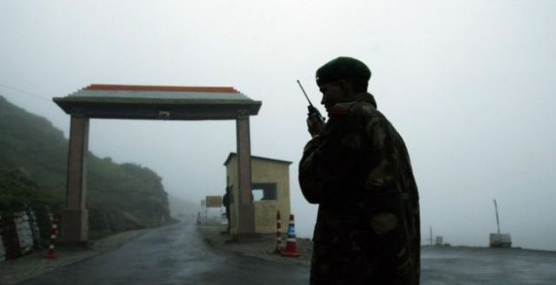
Arunachal Pradesh and the India-China
Conflict Part One
Ever since the first
reports of Chinese transgressions into Ladakh emerged in early May 2020,
experts warned India was staring at a formidable security threat.
Then recently, when China’s
new road cuts travel time to Karakoram Pass raised red flags, China
watcher Andrew Chubb responded with, "if Xi Jinping was to conclude
that Indian nationalist sentiments are so strong as to make escalation
inevitable, then he might be inclined to strike first, as Mao did in
1962."
Tens of thousands of
troops from both sides are still locked face to face, often just meters away,
with no resolution signs. Friday’s meeting saw both sides agree to maintain
“close consultations” at the diplomatic and military levels and convene again soon.
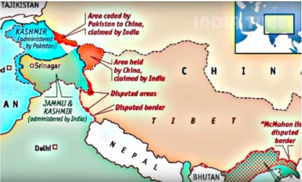
The two major border
issues between these neighbors, namely the territorial disputes of Aksai Chin
in the west and the McMahon Line in the east, no doubt, have their origin in
the colonial 'cartographic mischief' a subject about which we will present new
research.
In his 2020 book,
China's India War: Collision Course on the Roof of the World, Bertil Lintner
describes how the Chinese invasion of Tibet in 1950 dramatically altered the
geopolitics of the entire region. Until then, Tibet had closer ties to India
than China and was no longer a de facto independent country. One of the few in
the Indian government who understood the profound significance of this change
was the home minister, Vallabhbhai Patel, who, only a month before his death in
December 1950, wrote to Nehru,
We have to consider
what the new situation now faces us as a result of the disappearance of Tibet,
as we know it, and the expansion of China up to our gates. Throughout history,
we have seldom been worried about our north-east frontier. The Himalayas has
been regarded as an impenetrable barrier against threats from the north. We had
a friendly Tibet, which gave us no trouble. The Chinese were divided. They had
their domestic problems and never bothered us about our frontiers.
Whereby Lintner
proceeds with; China’s wars have always been ideologically motivated, meant to
show its superior strength vis-a-vis adversaries and to demonstrate socialist
solidarity with its ‘comrades-in-arms Describing describes China's People's
Liberation Army (PLA), as an ideologically motivated ‘people’s army.
Different from
Lintner, Ismail Vengasseri, in his book 1962 Border
War: Sino-Indian Territorial Disputes and Beyond (2020), argues that the
fundamental reasons that prompted Mao’s China to adopt a belligerent attitude
in its relations with India in the late 1950s stem from three aspects. First,
the USA's active intervention in the dispute with an extended arm of the CIA
providing military training to the Tibetan rebels, in addition to arms,
ammunition, and other logistical support, had no doubt aggravated the border
situation. The US factor is still a persisting issue as far as China is
concerned. Sino- Indian relations since 1949 have always been intricately
intertwined with the USA's active presence in between. The coven or oven
operations of the CIA along the border regions, colluding with agencies like
the anti-PRC Taiwan cliques, had been active on Indian soil. Hence, discussions
on armed Sino-Indian conflicts would be incomplete without reference to the
USA. the interventions of the USA had turned the border dispute into a military
conflict.
Second, overwhelming
interest in the Tibet issue prevailed in India, beyond international refugee
norms' standards. The Indian stand on the Tibetan issue and the passion and
enthusiasm it had shown in accommodating the Tibetan rebels on the grounds of
human rights played a role in worsening bilateral relations. When the Dalai
Lama became a favorite in Western and Indian media and was accorded reverence
on Indian soil with state honors at the cost of portraying China as a
belligerent undemocratic country, the friendship that India and China shared
gave way to mutual distrust. Nehru’s efforts to attain Asian unity, by
extending support to new Communist China in the face of a hostile Western
world, had gone in vain. The Chinese government accused India, stating that Tibetan
rebels were working at the behest of India’s instigation. They propagated the
idea that the expansionist policy of certain neighbors caused tension in the
Tibetan region. In this effort, China unsuccessfully tried to win over the
allegiance of various tribes inhabiting the border areas, which, no doubt,
encouraged disruptive elements in the north-eastern states and other border
regions. After several decades, when the Tibetan community assimilated to the
Indian society and was accommodated even in the Indian military and government,
Peking continued to allege that New Delhi was taking political advantage of
China's internal affairs.
Third, Indian
‘reactionaries’ efforts in colluding with the Western imperialists for
anti-China propaganda, which was an active component of Indian politics, played
an auxiliary role in this Sino- Indian issue. All of Nehru’s detractors, among
various parties, rallied in the name of Tibetan sympathy for active anti-Peking
rhetoric, which got strengthened in India with US backing. The covert relations
of Indian bureaucrats, press, and political leaders with the USA and other
external forces strengthened the anti-China debate not only at the frontiers
since 1961. But it is also illogical to assume that a militarily superior
nation would not dare to strike any time to score points in national or
international politics. But those who appraised the political authority about
an unreal situation in the border were responsible for the debacle.
Contemporary China’s recurring military muscle-flexing and belligerent attitude
in the border region is also a concern in this context. What was surprising was
that Peking had raised objections on several occasions when Indian official
dignitaries had visited the NEFA. The infrastructural development activities of
the Border Roads Organisation had also been objected
to by Peking. At the same time, China was suspected of encouraging subversive
activities in the region.
But as we shall
see, for all their continued relevance and ubiquity, territorial borders
are rarely examined through the historical practices and ideas that actually
produced them.
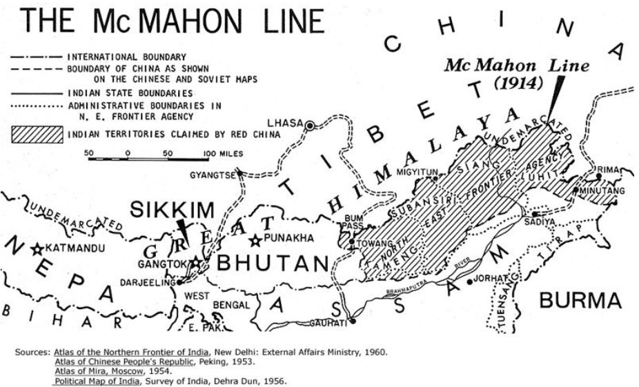
Lindner and Vengasseri both believe that central to the dispute is
the McMahon Line, a demarcation line between Tibet and the Northeast region of
India proposed by British colonial administrator Sir Henry McMahon at the 1914
Simla Convention signed between British and Tibetan representatives. It is
currently the generally recognized boundary between China and India. However,
the Chinese government disputes its legal status. But there is much more
besides McMahon as we will show next.
We tend to agree
with Vengasseri that the India-China border
dispute is, in essence, a collision between two essential different patterns of
legal thought.
Beyond the
Westphalian model of “perfectly equal” and exclusive states that dominates the
modern world system as a byproduct of European imperialism, there has existed
an array of multilayered conceptions of inter-state relations that were neither
“perfectly equal” nor strictly connected to the idea of exclusive control over
a bounded space.1 Even within those apparently Westphalian states, sovereignty
was far from being clearly delimited. In her recent work on law and geography
in the Longue durée of European empires, Lauren Benton has noted that “European
imperial pursuits” often produced “uneven legal geographies.”2 Although
Benton’s work largely focuses on maritime examples of sovereignty, law, and
geography, she also acknowledges that these “uneven” geographies included
undefined land borders, or ambiguous designations for particular spaces
(enclaves, corridors, etc.). While it is less surprising that maritime
sovereignty and territory should be rather fluid in the legal definition, it is
worth underscoring the distinction between the formal articulation of political
space and the result of practices employed to produce it. Geography was
employed to determine territory by attempting to rationalize and standardize
boundary-making principles and practices. Frontiers and borders were not only
physical spaces; they were spatial ideals reflecting a host of aspirations and
anxieties of the state, both imperial and national.
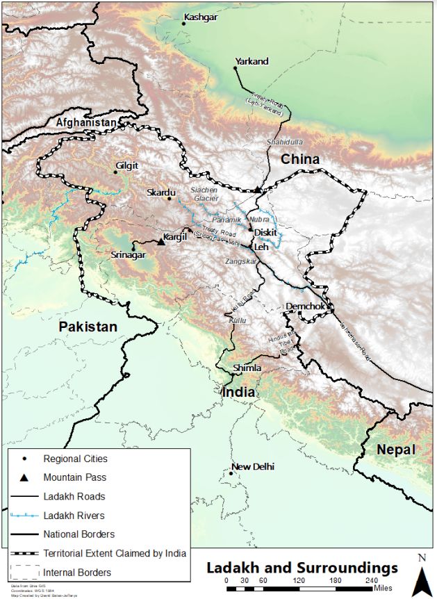
Ladakh and its surroundings (with terrain). Map by
David Bates-Jeffreys.
Geopolitics and the Making of Regions
In the late 1830s,
towards the end of his long reign, it is said that Maharaja Ranjit Singh was
shown a map that depicted in large swathes the extent of British-controlled
territory on the subcontinent. After looking upon the map in silence, the aging
ruler responded ominously, “sab lāl ho jāyegā [all will become red].”3 From his position in
Lahore, he had witnessed the rapid expansion of the East India Company’s
military-fiscal machinery and its ever-widening territory. With the defeat ofNepal'se recently unified Gurkha kingdom in 1816, the
British had taken their first territorial steps into the Himalaya. By the end
of the 1840s, the British had achieved, either by direct or indirect rule,
expansion towards what James Mill had called “the most desirable frontier” of
India.4 But a series of major problems soon arose. As we will show next, the
simultaneous and contradictory view of the northwestern Himalaya as both a
secure boundary and a commercial conduit produced a complex frontier for the
British. The prospect of accessing the region’s high-value trade networks would
tempt generations of British administrators and a couple of short-lived private
ventures. Yet the more time the British spent surveying this “most desirable
frontier,” the less clear that frontier became.
This political mode
of seeing distinctly reflected imperial concerns. It understood Ladakh to be
first and foremost a territory to be controlled, be it for economic, political,
or military gain. The political landscape of Ladakh had long been contested by
aspiring conquerors and home-grown rulers alike. But it was only with the
conquests of the 1830s and 1840s that the new rulers found it necessary to
enclose Ladakh in an often-shadowy borderline that symbolized unambiguous
sovereignty.
Complicating the
static territorial vision of this space were long-established networks of
trade. The seasonal change led to uncertainties in all spheres of daily life,
from trade and pilgrimage to crop yields and the survival of animal herds.
Flooding, precipitation, and unusual temperature fluctuations impacted pashmina
prices in India's far off plains and beyond. At the same time, these climatic
variables had an even more profound impact on staples consumed closer to home.
The crucial role played by the transhumant Changpa in
the wool and salt trades illustrates how critical migration was to the economic
livelihoods of many Ladakhis. These material
connections to the landscape did not neatly transpose onto a political vision
of territory.
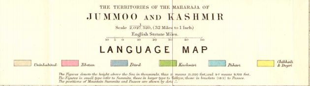
Detail from Frederic
Drew’s “Language Map.” Frederic Drew, The Jammu and Kashmir Territories. London:
Edward Stanford, 1875.
Similarly, the
Himalayan landscape was imbued with cosmological significance. This no doubt
resulted from an agricultural dependence on the land, but was also the result
of a deep mixing of spiritual traditions at this “crossroads of high Asia.”
Acknowledging this cosmological aspect of northwestern Himalayan space leads to
a multidimensional image of Ladakh that complicates a strictly political
conception of space. Mountains, rivers, streams, and trees were associated with
particular deities, many of whom were worshipped through sub-village and
village-level social groupings. This further connected individual Ladakhis to their local environments by means of a variety
of spiritual-spatial beliefs and practices. Through these connections, natural
features like mountains would, in many cases, become “centering” objects that
tied the landscape together rather than divide it.
While the bounding of
village-level geography was precisely reflected in walls, irrigation systems,
and other structures, the bounding of the larger polity of Ladakh was much less
defined. Instead, distances reflected the space between points such as a particular
mountain pass, stream, village, or pilgrimage site. As we will show, a novel
kind of geography would soon arise to transform the spatial conception of
Ladakh. A region that had long been a nexus would be increasingly pushed to a
new, ill-defined periphery.
The secure boundary and commercial conduit syndrome
A century after
Governor-General Hardinge had requested “clear and well-defined boundaries,”
the British still lacked a satisfactory border in the northwestern Himalaya. Mosts reflected by the production of this was reflected
maps that failed to include any borders in the region. As was later in 1962,
“Survey of India maps issued in 1865, 1903, 1917, 1929, 1936, and 1938 do not
show any boundary at all in the western (i.e., Ladakh) sector.”5 These
borderless maps illustrated the formal representation of territorial ignorance
on supposedly precise maps (See Figure 1.).
Figure 1. “Map of
India (showing provinces and districts).” Published under the direction of
Colonel Sir S. G. Burrard, Surveyor General of India, 1915. 1st Edition 1915;
2nd 1930; 3rd 1934; 4th, 1936. Scale 1 inch = 160 miles. IOR/X/9070. Courtesy British Library.
In the British
imperial context, the practice of imbuing maps with authority involved
transforming terra incognita into the colonial territory, a process that
oscillated between surveying the land and rendering it on paper. D. Graham
Burnett describes how Americans charged with resolving boundary disputes in
Guyana went in search of maps and documents in Europe, presuming the scientific
accuracy and the completeness of work done on the ground in the tropics of
South America. In appearing to present physicality, cartographic images attempt
to settle the political and technological struggles they represent.
The northwestern
Himalayan frontier's cartographical construction was itself an epistemological
development of the eighteenth and nineteenth centuries and drew on the work of
many geographers, most prominently Alexander von Humboldt, “the scientific traveler
par excellence.”6 For British surveyors and administrators of the
mid-nineteenth century, the naturalness of the great Himalayan barrier, and its
apparent linearity, could be reinforced through its water partings, which
increasingly acted as territorial demarcations and formed the basis of a major
principle of international boundary-making enshrined in international law by
the twentieth century. The rise of cartographical thinking illustrates both the
growing authority of colonial (and eventually postcolonial) maps and the
evolving logics of border making. Surveying and map-making came to represent a
vision of a space organized and triangulated through specific measurement and
vision technologies. But the clarity of that vision was often obstructed by complex
mountainous landscapes, as was the case in Ladakh and the broader northwestern
Himalaya.
The story of mapping
the northwestern Himalaya demonstrates that it is important to disaggregate
three apparently interwoven aspects of these colonial maps as historical
sources: first, the representation of land and water rendered on the map from a
variety of surveying practices and speculations; second, the lines drawn over
that representation to denote political units and their limits (aka territory);
and third, the cartographic and geographic rationales used to render and
determine the first and the second aspects. While historians of the Himalayan
borderland do acknowledge inaccuracies on maps (particularly pre-1899 maps) as
sources of disputes arising from this first aspect, they tend to ignore the
third aspect, the process and the rationale involved in making the land and its
supposedly natural boundaries conform to the map.
Paying closer
attention to how practices (the rise of the science of surveying, and the
coeval rise of the geographical sciences) and products (maps, survey reports,
the regular publications of the Royal Geographical Society) worked to
facilitate this shift to a more border centric world can reveal the deeply
uneven texture of the process of border making. Such an analysis could
denaturalize maps and denaturalize frontiers and the supposedly natural
foundations upon which they were established. The history of the long-elusive
border in Ladakh, a boundary supposedly derived from mountain systems and
watersheds, offers a perfect test case for such a revision. The production of
borderless maps of the northwestern Himalayan region reflected the simultaneous
lack of sufficiently precise information, and an unwillingness to acknowledge
that ignorance. It also reflected the unsuccessful application of a
geographical concept, the water-parting principle, that was meant to provide a
clear means to determining natural and political limits. The nature in natural
was all too human.
Unlike the North-West
Frontier with the Durand Line and the North-East Frontier with the McMahon
Line, the post-independence northwestern Himalaya never inherited a single
“line.” Like the McMahon and Durand Lines, the general principle of following
the water parting of the Indus watershed had long been accepted as the ideal
borderline in mountainous terrain. But the arid Aksai Chin offered no clear
mountain range upon which to impose such a line. As post-1947 surveys would
later reveal, much of the Aksai Chin would actually drain its waters into
the Tarim Basin, a self-contained, endorheic watershed, instead of the Indus.
But by the time of the transfer of power to an independent India in 1947,
Ladakh still had a number of lines of hypothetical borders. It had the Johnson
Line of 1865, the product of a traverse survey by William H. Johnson, who
likely sketched in (or had the Survey of India sketch in) a presumed crescent
of mountains that were not actually surveyed. Then there was the Macartney-MacDonald
Line suggested to the Qing Government in MacDonald’s now-infamous memorandum,
based in part of an earlier Chinese map given to George Macartney in Kashgar.
And then there were the maps with no lines at all. This last group of official
documents, products of the standardization and restriction of imperial maps,
reflected official acknowledgment of territorial illegibility. The requirements
for boundary demarcation exceeded the amount of information available about
India's mountainous northern periphery. This illegibility, and the official
practices that accompanied it, were bequeathed to India at independence.
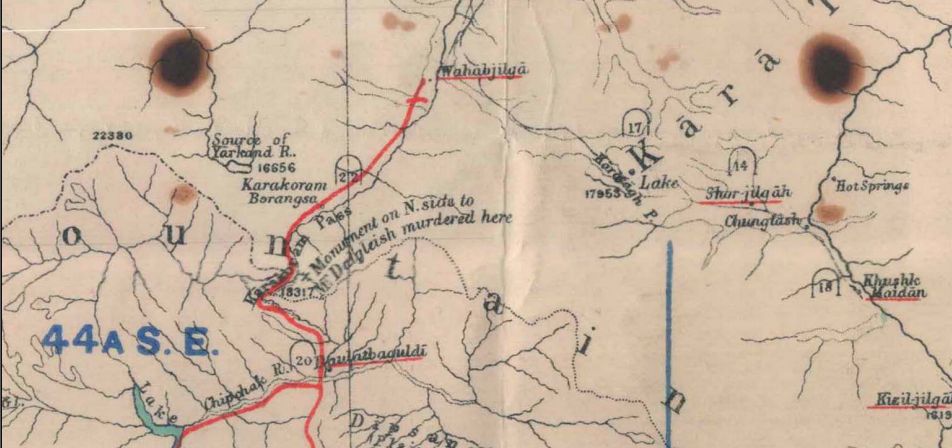
Figure 2. Detail of
“Territories of the Maharaja of Jammoo and Kashmir”
Calcutta: Thacker, Spink & Co., 1903. Note “Monument on N. side to Mr.
Dalgleish murdered here” is visible above the point marking the Karakoram Pass.
The northwestern
Himalaya’s continued borderless state also represented a profound irony to the
geopolitical sensibilities of the frontier experts who spent so much time
concerned with a region with neither immediate military threat, nor a large
commercial pay off. The region had been one of the key imperial laboratories
for border making and the development of the geographical sciences. It was
central to the concerns of frontier experts and geographers across the globe.
But when 1947 arrived, this once central “crossroads of high Asia” had become a
palimpsest of frontier configurations, configurations that reflected a
consensus on the geopolitical significance of this mountainous, inhospitable
space, but with no detailed survey to support the hypothetical borderline.
When the Radcliffe
Commission took six weeks to draw the lines that would partition India, they
dispensed with any of the rationalized border-making principles that such
people as Holdich had taken such pains to develop.7
Instead, the commissioners used district census records to determine, by
religious majority, which districts would belong to future India, and which to
Pakistan. Mountbatten even went so far as to state that it was not in his, nor
in Britain’s, interest to leave India and Pakistan with defensible borders.8
Post-independence friction along the newly demarcated borderlines was of no
concern to the imperial administrators eager to leave a country they could no
longer control.
In Ladakh, the
transfer of power was notable only in its absence. In 1946, the last British
Joint Commissioner left Leh at the end of another lackluster trading season and
did not return the following summer. The Resident in Srinagar did not bother
assigning someone to the posting when the transfer of power became apparent in
early 1947. Under the dual layers of Dogra and British rule, Ladakh’s political
existence became tied to Jammu and Kashmir's princely state. The exceptional
and “asymmetrical” features of the region that Ney Elias and many other
frontier experts had earlier noted complicated an already complex problem. The Dogras were a Hindu dynasty ruling over the Muslim-majority
Kashmir valley.9 This princely state, in turn, had come to rule over the
Buddhist-majority Ladakh. The uncertainty as to which state Jammu and Kashmir
would accede was mirrored within the state itself by concerns in Ladakh. Would
it join India or Pakistan? By the early 1950s, a third option also
materialized: Tibet
The geopolitical
significance of the region, coupled with the post-1947 disputed status of
Kashmir, put Ladakh in a paradoxical position. It was simultaneously central to
enormous magnitude's geopolitical tensions while increasingly isolated as part
of a still ambiguously defined territory. By becoming appended to the
imperial-turned-national frontier, Ladakhis slowly
became more aware of their isolated, peripheral position. More significantly,
as postcolonial nationalism infused the young state’s conception of itself,
that nationalism became attached to the territory bequeathed to it. But the
exact shape of that geo body was still far from clear.
Whereby the “McMahon
Line” was never fully demarcated on the ground, but was instead hastily
superimposed over a map of the borderlands and, like the infamous “Durand
Line,” became a source of post-independence territorial disputes.
Enter Olaf Caroe
As far as Tibet was
concerned, a more specific border demarcation, distinguishing its territory
from China, as well as the extent of the Tibetan autonomous region from Chinese
sovereignty as a ‘blessing’ from the British, was the avowed aspiration of
these sittings. The demarcation of a borderline between India and Tibet was
neither the professed aim of the tripartite Simla Convention nor was it a
concern for either Tibet or China. Therefore the red outer line did not go into
the nitty-gritty of the border between India and Tibet. But McMahon and the
team had secretly made efforts for an made the mystery surrounding their
actions a part of history, inserted fraudulent and falsified documents into the
archives which, in due course, largely influenced the historical narrative of
the nature of the Sino-Indian border. Since the Simla Convention had given a
fractured mandate, the McMahon Line had a fetal death at its inception itself.
What remains in the archives is the presence of Olaf Kirkpatrick Kruuse
Caroe's distorted version and, therefore, the borderline could better be
called the ‘Olaf Caroe Line’.
Olaf Caroe (15
November 1892 – 23 November 1981) was an administrator in British India,
working for the Indian Civil Service and the Indian Political Service. He
served as the Foreign Secretary to India's Government during World War II and
later as the Governor of the North-West Frontier Province (the frontier with
Afghanistan). As Foreign Secretary, he was responsible for reviving the McMahon
Line, which included the Assam Himalayan frontier (present-day Arunachal
Pradesh) within India. After retirement, Caroe took on the role of a strategist
of the Great Game and the Cold War on the southern periphery of the Soviet
Union. His ideas are believed to have been highly influential in shaping
Britain and the United States' post-War policies. Scholar Peter Brobst calls
him the "quintessential master of the Great Game" and the
"foremost strategic thinker of British India" in the years before
independence.
China's creative mapmaking
As we have described elsewhere, also the Chinese worked with what
they among others called 'Land and Water' maps in order to weaponize the study of history and
geography. Thus in 1928 the director of the Nanjing government’s Ministry of
Propaganda, Dai Jitao called for the establishment of geography departments at
all the country’s major universities, arguing that they would play a vital role
in national defense. The output of these departments was dedicated to serving
the state and its frontier mission. The Chinese historian Ge Zhaoguang has
described this period in academia as ‘national
salvation crushing enlightenment’ (jiuwang yadao qimeng).
The nationalists felt
the need to invent why the non-Chinese parts – Tibet,
Xinjiang, Mongolia, and Manchuria – should remain part of this new
country.
Yet how could they
persuade a child in a big coastal city, for example, to feel any connection
with a sheepherder in Xinjiang? Why should they even have a connection? The
general purpose of human geography was to explain how varying environments had
created groups with differing cultures. However, nationalism required all these
different groups to feel part of a single culture and loyal to a single state.
It was up to nationalist geographers to resolve the puzzle. They found two main
ways to do so. One group of textbook authors stated that all Chinese citizens
were the same: they were members of a single ‘yellow’ race and a single nation,
and no further explanation was needed. However, a second group acknowledged
that different groups did exist but were nonetheless united by something
greater. Within this group, some authors made use of ‘yellow race’ ideas; some
used the idea of a shared, civilizing Hua culture. In contrast, others stressed
the ‘naturalness’ of the country’s physical boundaries.
The multifaceted
image of the Han Chinese nationalism further developed in the buildup of modern
Chinese statehood. Han Chinese nationalists had created a hostile opinion
towards ethnic Uyghurs and Tibetans, viewing them as dangerous for the Chinese
state due to its cultural differences and lack of sympathy for ethnic Han
Chinese.
A major contribution
to this patriotic education movement was the series of textbooks written by
Zhang Qiyun. In 1928 the Commercial Press published one as Benguo
Dili – ‘Our Geography.’ Its key message was that China formed a natural unit
despite its enormous size and variety.
The book contained
various maps of the country drawn on blank backgrounds so that the rest of the
world disappeared from view. The simple black line marking the national
boundary encompassed huge areas that were not actually under the government's
control: the independent states of Mongolia and Tibet. Zhang portrayed them as
a natural part of the Republic, nonetheless. How reality would be reconciled
with the map was not explained to the pupils. Remarkably, given present-day
politics, there was a significant omission: Taiwan was not drawn in any of the
textbook's national maps. It seems that, in Zhang’s view, the ‘natural’ shape
of the Republic was exactly the same as the shape of the Qing Empire at its
collapse in 1911. Mongolia was included; Taiwan however was not. Neither were
today's so virulently disputed rocks and reefs of the
South China Sea did not feature at all.
Zhang's book was far
from being the only example. Dozens of geography textbooks were printed during
the 1920s and 1930s, and they all ignored Taiwan while stressing the importance
of Mongolia and Tibet.
The textbook writers
argued that the answer to the ‘border question’ was to ‘civilize’ the
inhabitants. One of the textbook writers at that time, Ge Suicheng, argued
that; ‘We should urgently promote the acculturation of the Mongols, Hui
[Muslims] and Tibetans so that they are not lured by the imperialists, [and we
should] move [Han] inhabitants to the border areas for colonization...’
The historians Robert
Culp and Peter Zarrow have documented many examples of other geography
textbooks that use different, sometimes contradictory arguments and analogies
to persuade students of the ‘naturalness’ of the Republic’s putative borders.
The leader of that
time nationalists Chiang Kai-shek lobbied Indian nationalists to win support
for his claim on Tibet and sought the early return of Hong Kong’s New
Territories from Britain.10 The British were not prepared to concede either
point, but they were willing to see Japan give back Manchuria and Taiwan. The
compromise was sealed at the Cairo Conference between Chiang, Churchill, and
Roosevelt in November 1943.
Chinese government troops this time under Mao invaded
Tibet on 7 October 1950.
By the late 1950s,
optimism in India over the Panchsheel (“five
virtues”) Treaty and overtures of Sino-Indian brotherhood (“Hindī-Cīnī
bhā’ī- bhā’ī”) had faded.48
The 1954 treaty that had asserted mutual respect between China and India on
issues of territorial integrity and sovereignty wrongly assumed that both sides
shared the same idea of those territories. That same year the Government of
India revised its official maps that showed “undemarcated”
or “undefined” borders in Ladakh to show a definite border, a composite line of
the Johnson Line of 1865 and the 1899 Macartney-MacDonald Line based on no
additional surveying or demarcation.49 This was, in Jawaharlal Nehru’s
estimate, the simplest way of dealing with the continued borderlessness
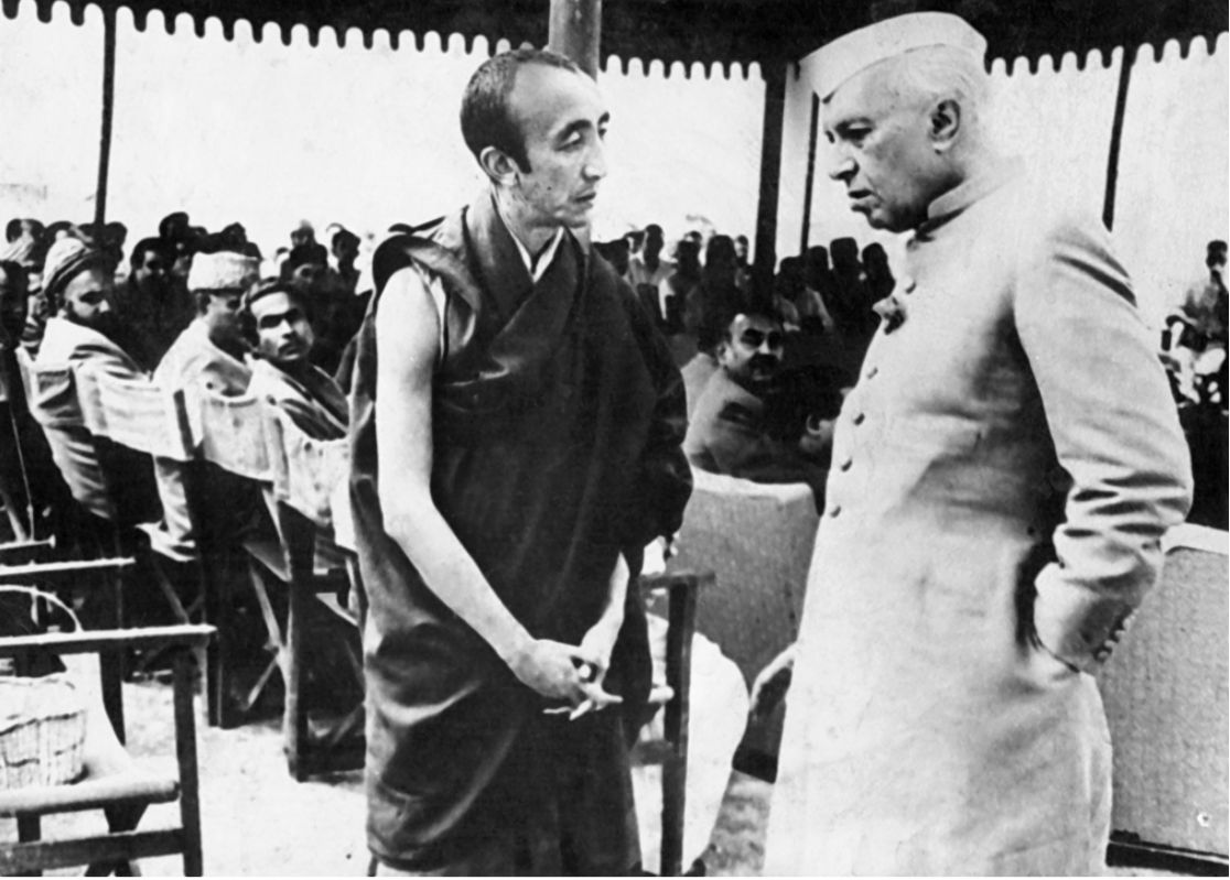
inherited from the British across much of the Himalaya. But when Bakula
Rinpoche (who served as the First Deputy Minister of Ladakh
Affairs) visited western Tibet in the summer of 1957, he reported to the
Indian government (pictured below) that the Chinese military had been
constructing a road across the uninhabited Aksai Chin plateau, connecting
Xinjiang and Tibet.
Sino-Indian relations
were made even worse when, in 1959, India received the Dalai Lama, who had fled
an uprising in Lhasa and was subsequently followed into exile by nearly one
hundred thousand Tibetans. And a series of incidents between Indian and Chinese
soldiers and officials in the northwestern and northeastern Himalaya began to
push Indian public opinion against China.
In writings produced
within the People's Republic of C and some scholarly writings abroad,
the term Tibet is used for the western half of the Tibetan plateau (referred to
in Chinese as the Qinghai-Tibet plateau) or at least those parts that currently
are claimed by China as lying within its borders. This area often
referred to in Tibetan as central Tibet but in fact, including much of far
western Tibet as well (Houzang or
“Farther Tibet,” as the Republicans called it), matched roughly the polity
directly ruled by the Lhasa-based government of which the Dalai Lama was the
head from 1642 till the arrival of the Chinese army in 1950–51. Since 1965, the
Chinese authorities and writers in China have also used the term “Tibetan
Autonomous Region” to refer to that area. Conversely, they refer to the
Tibetan-populated areas in the eastern part of the plateau as “Tibetan areas”
(Ch.: Zangqu) or more specifically as “Tibetan
autonomous areas” that are under the administration of the provinces of
Qinghai, Gansu, Sichuan, or Yunnan. However, the former government in Lhasa
claimed and at certain times had control of some areas particularly in the
eastern half of the plateau, the northeastern and southeastern part.
The nature of the
British's border dispute at their departure remained dormant between the two
nations. The official documents of the government of British India in the years
preceding their departure show a vivid picture of such a dispute that had been
lying latent in both sectors. Records reveal that the nationalist government in
China had served several protest notes to British India because border posts in
the north-east frontier region were pushed from the foothills of Assam towards
the vicinity of the McMahon Line. The republican government had sent protest
notes to the British Embassy in China. In April 1947, during the Asian
Relations Conference in New Delhi, Chinese delegates protested against a map of
Asia showing Tibet outside the boundaries of China, and subsequently, the map
was withdrawn. This shows that the disputes were present even before the
departure of the British and that it did not originate between the PRC and
independent India. However, in the early half of the 1950s, Peking and New Delhi
adopted cordiality in relations and did not immediately speak their minds on
the border issue. But a silent phase of frontier consolidation was in progress
on both sides, without leading to clashes.
In 1951, India
peacefully annexed Tawang and started implementing
the reports of the Himmatsinhji Committee in the
period 1951-1954 by mobilizing frontier posts. At the same time, India extended
several friendly gestures, including recognition of Tibet's Chinese occupation,
and relinquished all its privileges in that territory. But during this period,
the PRC made an impression that it was by and large silent on the border issue.
However, Peking was also actively working on a secret construction of a road connecting
Sinkiang and Tibet through Aksai Chin. China strongly believed that independent
India’s perception of the frontiers with China was basically based on British
imperialist devices' outcome. But the issues were slowly entering a phase of
complication by 1954-1955 with the publication of a new map by India in 1954
specifying the Sino-Indian borderlines as per its claim. So the divergence
between the two nations in the perception of the border started getting stark
as early as the bhai bhai days. In the meantime, the
news of Aksai Chin road also began to get attention by 1957. When the issue of
the road was brought to Peking's attention, they pointed out that New Delhi’s
occupation of the North-East Frontier Agency (NEFA) was based on an imperialistically
devised McMahon Line that was illegal. Despite all these grey areas, bilateral
relations were cordial and not complicated, and any serious divergence in perception
of the border began to get aggravated only at a later point. It was with the
Tibetan Uprising in 1956 and New Delhi’s expression of empathy with the
rebellion.
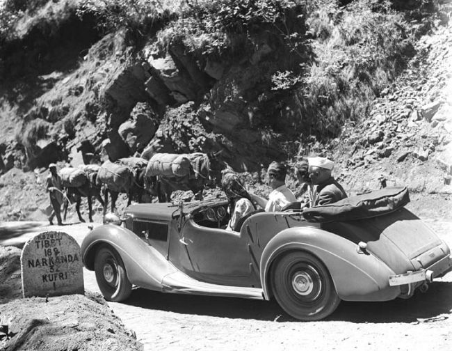
Jawaharlal Nehru,
Louis and Edwina Mountbatten, and an unknown woman in a car on the
Hindustan-Tibet Road in Shimla. The sign says “Tibet 182 [miles].
In part two we will
detail how the legacies of the 1962 war continue
to shape our perceptions.
In part three we will
detail the CIA's involvement in the 1962 war
and what all of this means for today.
1. The degree to
which the Westphalian model can lay claim to a modern form of sovereignty,
superseding pre-modern models like tributary systems has been a source of
debate among historians, most notable historians of Qing China. James Hevia’s
Cherishing Men from Afar: Qing Guest Ritual and the Macartney Embassy of 1793
(Durham, N.C.: Duke University Press, 1995) called into question John
Fairbank’s Chinese “tributary system” by illustrating the degree to which Qing
“guest ritual” during the Macartney Embassy (1793) constituted a Qing
conception of sovereignty that was neither solely a guise for trade, nor the
isolationist and Sinocentric behavior that the British read it to be. Rather,
Hevia argued, the embassy represented two competing views of sovereignty
articulated by two expanding empires. Elsewhere, Hevia has also called
attention to the degree to which the British themselves employed tributary
systems within their own empire. See James L. Hevia, “Tributary Systems,” The
Encyclopedia of Empire (John Wiley & Sons, 2016).
2. Benton, A Search
for Sovereignty: Law and Geography in European Empires, 1400-1900, xii.
Although borders and borderlands are ubiquitous in the modern world, historians
and political scientists often restrict their analyses to the political
rivalries between imperial powers and their successor states. In so doing, they
tend to overlook the physical practices that generated what is now often
considered to be “peripheral” spaces. By drawing on insights from anthropology,
geography, and environmental studies, I argue that the use of geography by the
British imperial state reveals the increasingly intimate relationship between
imperial security and the process of conceptualizing and making legible
political territory. This relationship reflects a major spatial reorientation
of the modern period, a geopolitical vision of the world as a set of
coterminous territories tied to, and dependent upon, geographical features.
This history also suggests that on its periphery at least, the postcolonial
state is often still an imperial one.
3. The episode may be
apocryphal. Majumdar in his Advanced History of India (p. 741) mentions the
remark but fails to give a source, date, or location. Was it originally spoken
in the given Hindustani or in the maharaja’s native Punjabi (“sabh lal ho javega”)?
More context is given in a less authoritative chapter by S. K. Pachauri,
“British Perceptions of Relations with Maharaja Ranjit Singh,” in Maharaja
Ranjit Singh: Ruler and Warrior, ed. T. R. Sharma (Chandigarh: Panjab
University Publication Bureau, 2005). No mention of the statement is made in
Jasbir Singh Ahluwalia and Parm Bakhshish Singh’s An Overview of Maharaja
Ranjit Singh and his Times (2001), or in the expansive Life and Times of Ranjit
Singh: A Saga of Benevolent Despotism, by Bikrama Jit
Hasrat (1977). Despite the questionable nature of its origin, it is instructive
to note that Ranjit Singh has recently reemerged as a major political figure of
South Asian history whose short-lived empire has wrongfully been consigned to a
peripheral position because of its defeat by Britain and the relatively more
central role played by the declining Mughal empire in the central narrative arc
of South Asian political history. For an example of this type of literature,
see Patwant Singh and Jyoti M. Rai, Empire of the
Sikhs: the life and times of Maharaja Ranjit Singh (2008).
4. “Evidence of James
Mill,” 16 February 1832: Parliamentary Papers, 1831-2, Vol. xiv, p. 8, Qu. 49.
83
5. National Archives
of the United Kingdom (NAUK). DO 196/190, 1962, “India’s Himalayan Frontier.”
6. Kapil Raj, “La
Construction de L’empire de La Géographie: L’odyssée Des Arpenteurs de Sa Très
Gracieuse Majesté, La Reine Victoria, En Asie Centrale,” Annales. Histoire, Sciences Sociales
52, no. 5 (October 1997): 1157.
7. The history of the
Partition of India has generated a vast body of work. Recent notable histories
include: Joya Chatterji, Bengal Divided: Hindu Communalism and Partition,
1932-1947 (Cambridge: Cambridge University Press, 1994); Yasmin Khan, The Great
Partition: The Making of India and Pakistan (New Delhi: Penguin, 2007); Vazira Fazila-Yacoobali Zamindar, The Long Partition and
the Making of Modern South Asia: Refugees, Boundaries, Histories (New York:
Columbia University Press, 2007).
8. Chatterji, “The Fashioning
of a Frontier: The Radcliffe Line and Bengal’s Border Landscape, 1947-52.”193.
9. See Mridu Rai,
Hindu Ruler, Muslim Subject: Islam, Rights, and the History of Kashmir
(Princeton: Princeton University Press, 2004); Chitralekha Zutshi, Languages of
Belonging: Islam, Regional Identity, and the Making of Kashmir (New York:
Oxford University Press, 2004).
10. Melvyn C.
Goldstein, A History of Modern Tibet, Berkeley, CA: University of California
Press, 2007, pp. 314–49; Simon L. Chang, ‘A “Realist” Hypocrisy? Scripting
Sovereignty in Sino-Tibetan Relations and the Changing Posture of Britain and
the United States’, Asian Ethnicity, 26 (2011), pp. 325–6.
11. Literally
translated as “Indian-Chinese brother-brother,” the term was used to refer to
the Indian government’s post-independence assertion of a longstanding
historical connection and growing brotherhood between the two countries,
underscored by the 1954 Panchsheel Treaty.
12. Alastair
Lamb, The Sino-Indian border in Ladakh (Asian publications series),
1975, 70.
For updates click homepage here