By Eric Vandenbroeck
The India-China Border Dispute
As Ismail Vengasseri wrote in his recent
book about the India-China border standoff where Tibet plays an important
role, that history is testimony to the fact that uncertain border definitions
have proved to be a hurdle in maintaining friendly relations across frontiers,
and this, in turn, has created clashes and conflicts. This continues to be one
of the greatest concerns between neighboring nations, the ‘tripwires of war.’
Over the years,
debates around frontiers have tended to trigger discord and disharmony, and
even now, border disputes have been the source of some of the major wars. The
case has not been any different in Europe, but despite their experiments on
‘withering walls,’ they have managed to define their borders by and large. Most
of the major European wars in history were fought on the issue of territorial
frontiers, and this might have prompted Lord Curzon to rightly observe,
‘Frontiers are indeed the razor’s edge on which hang suspended the modern
issues of war or peace, of life or death to nations.’1
And as already
pointed out by A. G. Noorani, in The Truth about 1962',
in Indie-China Boundary Problem 1846-1947, these issues have been
inherited as a legacy of the British colonial administration and as we
added in part one by China's own creative
mapmaking.
As for India, Claude
Arpi says that Director, Vigilance, Ministry of Defence,
issued a letter dated 12 October 2011, with the approval of the Defence Secretary, stating that none of the remaining
(five) reports: (i) PMS Blackett Report 1948; (ii) Himmatsinghji Report, 1951; (iii) H. M. Patel Committee
report on the functioning of the Ministry of Defence,
1952; and (vi) Sharda Mukherjee Committee report on restructuring Ministry of Defence 1967;... are avail- Arpi expresses apprehension
whether these reports have lost forever. In such prevailing situations that
Noorani says, ‘the nation must be told the truth, the historical truth since
1842 and the truth about Indian diplomacy since 1947’.3
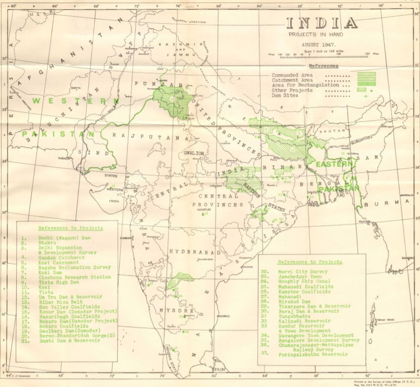
In a dark corner of
the main reading room at the National Archives of India, New Delhi hangs an
unusual map. Rendered in the standard colors of political maps of the late
British Empire, this 1950 Survey of India production has one peculiar feature.
In one huge segment of its northern extreme, there is no sign of a border.
Instead, the ubiquitous pink wash signaling imperial control gradually fades
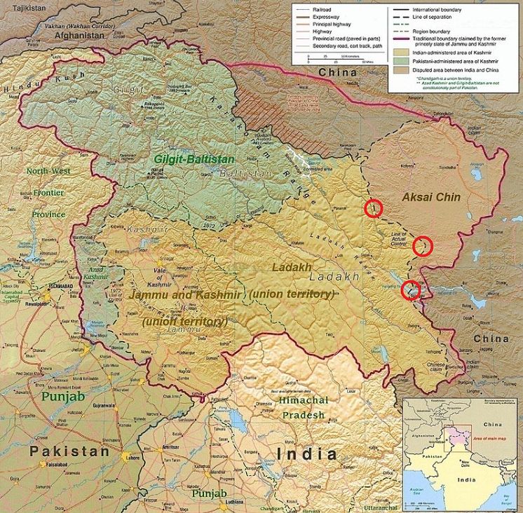
into northwestern Tibet's empty white space, a region now generally referred to
as the Aksai Chin. In this Switzerland-sized high-altitude region, the map
showed no borderline and no stark color contrast to delimit territorial
control, nothing but the official acknowledgment of an absence. For the
colonial and early post-colonial governments of India, the empire’s
northwestern Himalayan border was a “known unknown,” to evoke a hierarchy of
ignorance from a more recent moment of imperial hubris. 4 Numerous maps
produced by the Survey of India from the late nineteenth century up to, and
shortly after, independence and partition in 1947 show similar
details. See here, Survey of India, “India: Projects in Hand.” August
1947:
The imperial legacy
of an undemarcated boundary, an ambiguity that
troubled but was tolerated by the British Raj, eventually culminated in a
deadly face-off across the desolate Aksai Chin in 1962.5 This brief Sino-Indian
War imposed the first effective borderline in the region, referred to in India
as the “Line of Actual Control” (LAC), through the line has yet to be
demarcated by boundary commissions from either side.6 Not only is the vast
territory of this virtually uninhabited region between the world’s two most
populous nations still contested, but its cartographic representation has also
become a major concern for the Indian state. In 2015 the Indian government
banned Al Jazeera from the television airways for five days in response to the
news networks’ failure to show territories now occupied by Pakistan and China
in the northwestern Himalaya as part of India, a move the government labeled a
“cartographic aggression.”7 And a year later legislation was unsuccessfully
introduced in India’s national assembly to criminalize maps failing to
represent India’s claimed border.8 In responding to these “aggressions,”
India's government was also responding to a legacy of colonial borders and the
inheritance of an imperial frontier. The empire had tolerated a degree of
ambiguity in its frontiers and borders that the new nation-state could not. But
despite the existential significance of the young nation-state’s border, how
that border was created, or failed to be created, was a legacy of empire and
the way the empire came to view its territory.
Thus when India became independent in 1947 and
confederated several princely states into the Indian Union, China waged a civil
war to define its nation’s future destiny. The timing was not conducive for
either party to define the borders but to accept the existing status. So the McMahon Line became India’s north-east
border, inherited from the British as the ‘legitimate’ border. However,
when the newly established PRC took over Tibet in 1951, it was unwilling to
recognize the British legacy as a tag on its borders. However, though disputed
on the McMahon Line's validity, the LAC in this sector also runs along the same
alignment.
One can ad that even
though China suggests that an area of about 90,000 sq. km in this sector is
disputed territory, it presents one of the most feeble
disputes in this sector due to a complex political situation under imperialist
intervention.
But for all their
continued relevance and ubiquity, territorial borders are rarely examined
through the historical practices and ideas that actually
produced them.
The Birth of Geopolitics
To understand the
above one has to go back
to Shimla, where, between October 1913 and July 1914,
plenipotentiaries of the newly formed Republic of China, the British Government
of India, and the Government of Tibet met to define the territorial limits and
political status of Tibet. According to Viceroy Hardinge, Tibet’s ambiguous
status vis-à-vis India and China and its undemarcated limits produced
a situation “of constant anxiety.”9 Even before the Younghusband expedition
violently opened Tibet to the British, frontier policy had divided imperial
politics. For Curzon and those who subscribed to his “forward” policies in
South Asia, Tibet represented both a logical extension of a general strategy
involving loose political control over the Himalayan states (Bhutan, Nepal,
Sikkim) and a sensitive subject, considering Chinese claims to suzerainty over
the mountainous region. By 1910, following an incursion by Zhao Erfeng, India's British Government had become concerned
that “China had come to the gates of India.”10 Following the Chinese Revolution
of 1911, the British decided that the solution to the “Tibetan
Question”—defining Tibet about China and British India—should be a condition of
their recognition of the new Chinese government. The British made their diplomatic
recognition of the new Chinese republic contingent upon China’s recognition of
Tibetan autonomy. On October 7, 1913, Yuan Shikai
acknowledged this and the British, in turn, recognized the Republic of China on
the same day.11
The Dalai Lama
tactfully thanked the “Great British Government” for its kindness in deciding
to hold a conference “between the British, Chinese and Tibetans regarding ChineseTibetan affairs.”12 Charles Bell noted the terms by
which the Dalai Lama wished to define Tibet. He wanted “Tibet to manage her own
internal affairs; To manage her own external affairs, consulting on important
matters with the British; To have no Chinese High Commissioner, no other
Chinese officials [Ambans], and no Chinese soldiers in Tibet; Tibet to include
all the country eastward as far as Tachienlu.”13 The Dalai Lama, Bell
recounted, had a capacious understanding of what constituted Tibet, considering
it to include most of the intervening land between central Tibet and
Mongolia.14 The Chinese government, not surprisingly, wanted the opposite: a
reassertion of its political control over Lhasa and the inclusion of Tibet
within the boundaries of the Republic of China.
The conference's
British goals were two-fold; first, they desired to secure the maintenance of
peace and order on the Indo-Tibetan border,15 and second, they wanted to ensure
that the controlling influence at Lhasa was not overtly hostile to India or the
frontier states.16 Some Chinese scholars have since noted that Britain clearly
sought to make Tibet a British protectorate.17
After two months of
talks, the British representative, Henry McMahon, decided that both the Tibetan
and Chinese representatives should prepare cases to support their specific
claims to territory and sovereignty. In a move that suggested that his stance as
an equal arbiter was anything but, McMahon decided he would act as judge in
determining which case was more compelling. The conference resumed on January
12, 1914, when Lonchen Shatra
Paljor Dorje, the Prime Minister of Tibet) and Ivan
Chen (Chen Yifan, the Special Commissioner for Foreign Affairs in Shanghai)
presented their evidence.
The Tibetan case was
substantial: over 90 original Tibetan documents including “inscriptions of
boundary pillars, census reports, tax and revenue records, extracts from
written histories, registers of legal cases, lists of official appointments,
monastic records, bonds of allegiance between territories and the Tibetan
Government, and correspondence between the Chinese and Tibetan governments
regarding certain territories.”18 The Chinese side, on the other hand,
presented a single general statement for their claim, which rested on
“effective occupation” and “Qing Dynasty relations with Tibet reclaimed by the
new Chinese Republic.”19 As Carole McGranahan observes, “the status quo was
interpreted differently by each: “autonomous to the British, suzerain to the
Chinese, and independent to the Tibetans.”20
McMahon then
presented the British position: a non-negotiable “compromise” that included the
radical division of Tibet into two zones: “Inner Tibet” and “Outer Tibet,” a
bifurcation that had no historical precedent but was based loosely on the
traditional regional divisions of central Tibet, Dbus-Gtsang, one of three
historical regions of Central Asia (the other two being A-mdo
and Khams) into which Tibet was once divided. As Political
Officer in Sikkim and friend to the thirteenth Dalai Lama noted that in “Outer
Tibet the Dalai Lama retained practically complete control. Inner Tibet was to a large extent opened to the Chinese. However, the Dalai
Lama retained full religious control, and the right of appointing the various
local chiefs throughout the territory.”21
After six months of discussions, a draft of the treaty was initialed by all
three representatives and sent to their respective governments for final
approval. Great Britain and Tibet approved the draft on July 3, 1914, but China
did not.22 As Charles Bell wrote: Two days after the Chinese, Tibetan, and
British plenipotentiaries had initialed the Convention, the Chinese Government
telegraphed repudiating it. Tibet and Britain, however, recognized it as
binding on themselves. Having repudiated the Convention, China was of course
entitled to none of the advantages, for instance, the opening to Chinese of
Inner Tibet, which the Convention would have conferred upon her. […] In due
course the British and Tibetan Plenipotentiaries signed the agreement in
respect of the frontier and respect of the trade regulations, thus making both
a part of the Simla Convention.23 Just one month after the conclusion of the
conference, Great Britain entered the First World War. Tibet had found—it
believed—an ally in Great Britain and the Dalai Lama offered to send a thousand
Tibetan soldiers to fight alongside the British.24 The empire would prove,
however, a fickle friend. The “Simla Agreements of 1914” and early British
documents relating to Tibet’s political, diplomatic, and trade status, have
long been used to fight over historical recognition of an independent Tibetan
state.25 Ironically, the McMahon Line, used by the British to craft its vision
of a buffer region with China became the principal model on which the People’s
Republic of China created its Tibetan Autonomous Region (TAR) model.26
Progress at the
Shimla Conference was principally slowed by the boundary between Tibet and
China and the broader and ambiguous definition of Tibet’s relationship to
China. As a “perfectly equal” arbiter between the two other parties, Britain
had the final say in drafting the treaty.27
Thanks to the
combined survey work of multiple boundary commissions in the eastern Himalaya
and Burma, McMahon’s line rested on an emerging vision of the Himalayan
watershed. Surveys completed in 1911 and 1912 in the North-East Frontier “so
added to [the Government of India’s] geographical knowledge” that it became
possible for the first time to “make a general
definition of the frontier line.”30 The surveyors began at the northernmost
demarcated point of the Burma-Yunnan boundary and worked westward. With only
two minor exceptions in Sikkim, the main watershed of the Himalaya formed the
natural and strategic (i.e. scientific) frontier between India and Tibet. This
was in keeping with Henry McMahon’s demand at the Simla Conference that the
line followed the watershed limit. McMahon’s “heart was set on having the
boundary lines along high water partings” instead of the border points already
established as noted by Charles Bell.31 Bell also observed that although at
present the Indo-Tibetan frontier, “some 1,600 miles from Kashmir to beyond the
north-eastern corner of Assam,” was the “least troublesome” of India’s
frontiers, that situation could change with the granting of self-government.32
Responding to a request from the Foreign Department regarding the impact of
giving self-governance to the people of India, Bell noted that to avoid
“constant friction” and “serious trouble” along the frontier, the government of
India should implement and directly govern “a strip of land dividing [the
border] from the self-governing communities of India.” While never implemented,
Bell’s plan spoke to the continued anxieties regarding the indirectly ruled
territories along the frontier. Such a critical element of the imperial state
should not be left in the hands of local powers. The frontier's growing
importance as the razor’s edge” determining “life or death to nations” revealed
just how intimately tied politics and geography had become.33
Taken together, the growing
concerns over-penetration from beyond the frontier by transfrontier
groups, the need to gather and restrict trans-frontier information, and the
imperial preoccupation of determining the lines that would mark the imperial
perimeter reflected a broader change in how geography and the state functioned
together. By the turn of the twentieth century, the imperial state came to see
space in a new and particular mode, one where
territory and the state were co-terminus entities and where the border was the sine
qua non of the state’s existence. This process of “re-visioning,” as John Agnew
has noted, had its roots in Renaissance European notions of the world as “a
structured whole.”24 But it only emerged as a self-conscious science in the
late nineteenth century. With his usual dramatic flourish, Thomas Holdich summed up this transformation. “Time was (and not
so very long ago either) when the whole wide area of scientific knowledge
embraced in the broad field of geography was narrowed to a ridiculous little educational
streamlet which babbled of place-names and country
products.”25 But by the time Holdich became a leading
member of the RGS, the days of the babbling “educational streamlet” of
geographical knowledge were over. Geography was not only a science, it had become a political science.
But as explained in part one a century after
Governor-General Hardinge had requested “clear and well-defined boundaries,”
the British still lacked a satisfactory border in the northwestern
Himalaya.
Just as memories of
1962 begin to get less intense with the younger generations in both countries,
the legacies of 1962 continue to shape our attitudes and perceptions. This was
witnessed rather dramatically when the Galwan Valley clash took place between
India and China in
2020. Among the number of lessons that it drove home, the most significant
one might have been how the complex and knotty ‘historical’ legacies
resurfaced, and the extent to which confusions and obfuscations continue to
cloud the average understanding.
In part one we see
how mapmaking by both the British and the Chinese showed the growing
concerns over-penetration from beyond the frontier by transfrontier groups,
the need to gather and restrict trans-frontier information, and the imperial
preoccupation of determining the lines that would mark the imperial perimeter
reflected a broader change in how geography and the
state functioned together.
In part three we will
detail the CIA's involvement in the 1962 war
and what all of this means for today.
1. Lord Curzon
of Kedleston, Frontiers in Oxford Lectures on History 1904-23, Vols.
1-58 (Oxford: Clarendon Press, 1924), 7. Quoted in Bardo Fassbender and Anne
Peters, ed., The Oxford Handbook of the History of International Law, 240.
2. A.
G. Noorani, The Truth about 1962', in Indie-China Boundary Problem
1846-1947 (Oxford: Oxford University Press, 2011).
3.
Noorani, 'The Truth about 1962'.
4. Though earlier
instances of the phrase can be found, it was made famous by President George W.
Bush’s Secretary of Defense, Donald Rumsfeld, during a Department of Defense
news briefing on February 12, 2002. Rumsfeld used the term in response to evidence
linking the Iraqi government's alleged supply of weapons of mass destruction to
terrorist groups.
5. As well as the
equally inhospitable terrain of the northeastern Himalaya in the region now a
part of the Indian state of Arunachal Pradesh, but referred to by the Chinese
government as Zàngnán (“South Tibet”)
6. Shaurya Karanbir
Gurung, “India and China Need to Demarcate LAC,” The Economic Times, September
6, 2017,
http://economictimes.indiatimes.com/news/defence/india-and-china-need-todemarcate-lac/articleshow/60383451.cms.
7. Avaneesh Pandey,
“India Bans Al Jazeera for 5 Days Over ‘Incorrect’ Kashmir Map,” International
Business Times, April 23, 2015.
8. Officially titled The
Geospatial Information Bill of 2016.
9. “Viceroy on Indian
Affairs: British Foreign Policy,” The Times, 18 September 18, 1913.
10. Premen Addy, Tibet on the Imperial Chessboard: The Making
of British Policy Towards Lhasa, 1899-1925 (Calcutta and New Delhi: Academic
Publishers, 1984), 212.
11. Jonathan D.
Spence, The Search for Modern China, 2nd ed. (New York: W.W. Norton, 1999).,
283; and Jerome Ch’en, Yuan Shih-k’ai
(Stanford, CA: Stanford University Press, 1972)., 142.
12. IOR,
L/P&S/10/400, Gould’s translation of a letter from Dalai Lama to Basil
Gould, July 10, 1913.
13. Charles
Bell, Portrait of a Dalai Lama: the life and times of the Great
Thirteenth,2000, 204. Dajianlu, i.e. Kangding.
14. Bell recounts
this in Portrait of the Dalai Lama, or Tibet: Past and Present.
15. Alastair Lamb,
The McMahon Line: A Study in the Relations between India, China and Tibet, 1904
to 1914, vol. 2, 2 vols. (London: Routledge and Kegan Paul, 1966).
16. Tsepon W. D. Shakabpa, Tibet: A
Political History (New Haven and London: Yale University Press, 1967), 252-3;
and extract from Viscount Morley’s speech the House of Lords, 17 October 1913
(Hansards Debates). McGranahan has examined three sets of contemporary
materials on the conference and found them all to agree (note 18, p. 289: “The
texts are as follows: (1) original documents in the India Office Library,
London, especially in MSS Eur F 80/177, (2) the Tibetan text shing.stag rgya.gar ‘phags.pa’i.yul du.dbyin bod.rgya gsum chings.mol
mdzad.lugs kun.gsal me.long (The Mirror of Clear Reflection about the Simla
Treaty between Britain, China, and Tibet in the Wood Tiger Year), and (3) an
English text published in China: The Boundary Question between China and Tibet:
A Valuable Record of the Tripartite Conference between China, Britain, and
Tibet held in India, 1913—1914. Peking, 1940).”
17. Wang Hui, for
instance, writes: “Britain’s position was that Tibet should become a British
protectorate and stay on only nominally as a highly autonomous region under
China—this so called high degree of autonomy did not
mean that Tibet should actually be autonomous, but was an indication of the
authority of the British protectorate.” Wang Hui, The Politics of Imagining
Asia (Cambridge, MA, and London: Harvard University Press, 2011), 158. While
his political views of Tibet confirm, in many ways, to the Communist Party’s
standard argument regarding Tibet’s integral historical position within the
Chinese state, Wang’s articulation of British aspirations towards Tibet at the
time of the Shimla conference is insightful.
18. Carole
McGranahan, “Empire and the Status of Tibet: British, Chinese, and Tibetan
Negotiations, 1913—1934,” in The History of Tibet, Vol. III: The Modern Period:
1895—1959, the Encounter with Modernity, ed. Alex McKay (London and New York: RoutledgeCurzon, 2003), 270-1.
19. McGranahan,
“Empire and the Status of Tibet,” 271.
20. McGranahan,
“Empire and the Status of Tibet,” 280.
21. Sir Charles Bell,
Portrait of the Dalai Lama, 204-206.
22. McGranahan, “Empire
and the Status of Tibet,” 269.
23. Sir Charles Bell,
Portrait of the Dalai Lama, 204-206.
24. K. Dhondup, The Water-Bird and Other Years: A History of the Thirteenth
Dalai Lama and After (New Delhi: Rangwang Publishers,
1986), 54. The offer was not accepted.
25. Until 2008, the
British Government's position remained constant regarding China’s
suzerainty—but limited sovereignty—over Tibet. Britain was the sole state to
maintain this view. However, its position was revised when, on 29 October 2008,
it recognized Chinese sovereignty over Tibet by stating on its website. India’s
current claims to a part of its northeast territories, for example, is largely
based on the same agreements—notes exchanged during the Shimla convention of
1914, which set the boundary between India and Tibet. articulate theories
about military strategy on land and at sea.
26. McGranahan
“Empire and the Status of Tibet,” 288. 158 The language of the Simla Agreements
of 1914 is filled with the language of diplomatic equality: “settle by mutual
agreement.” For a discussion of “perfect equality” in British diplomacy, see
James L. Hevia, English Lessons: The Pedagogy of Imperialism in NineteenthCentury China (Durham, N.C.: Duke University
Press, 2003). 159 I.e. dividing Tibet into two regions (Outer and Inner) while
“recognizing that Tibet is under the suzerainty of China,” while also
“recognizing the special interest of Great Britain in virtue of the
geographical position of Tibet” and prohibiting China and Tibet from “enter[ing] into any negotiations or agreements regarding Tibet
with one another.” 160 See, for these ambiguities, Articles 2, 3 and 5 of the
Simla Agreements of 1914, in Goldstein, History of Modern Tibet, 833.
27 The language of
the Simla Agreements of 1914 is filled with the language of diplomatic
equality: “settle by mutual agreement.” For a discussion of “perfect equality”
in British diplomacy, see James L. Hevia, English Lessons: The Pedagogy of
Imperialism in NineteenthCentury China (Durham, N.C.:
Duke University Press, 2003).
28. I.e. dividing
Tibet into two regions (Outer and Inner) while “recognizing that Tibet is under
the suzerainty of China,” while also “recognizing the special interest of Great
Britain in virtue of the geographical position of Tibet” and prohibiting China
and Tibet from “enter[ing] into any negotiations or
agreements regarding Tibet with one another.” 160 See, for these ambiguities,
Articles 2, 3 and 5 of the Simla Agreements of 1914, in Goldstein, History of
Modern Tibet, 833.
29. See, for these
ambiguities, Articles 2, 3 and 5 of the Simla Agreements of 1914, in Goldstein,
History of Modern Tibet, 833.
30. NAI, Foreign,
Secret E., September 1915, nos. 76-101. “India. Definition of Indo-Tibetan
Boundaries.”
31. Charles Bell to
the Political Officer in Sikkim, October 5, 1919. NAI, Foreign, Secret E.,
February 1920, keep-with no. 112. “Tibetan question. Chinese proposals for the
final settlement of the Tibetan question. Acceptance of offer and decision that
negotiations should be re-opened, with Chinese Government at Peking at which
Tibet should not be represented.”
32. Charles Bell,
P.O. Sikkim, to A.H. Grant, November 13, 1917. NAI, Foreign, Secret E., May
1918, nos. 146-147. “Effect on the Indo-Tibet Frontier of the grant of
Self-Government in India. Question of the creation of a non-self-governing belt
of India to act as a buffer between selfgoverning
India and Tibet, Nepal, Sikkim, Bhutan and Kashmir.”
33. George
Nathaniel Curzon Curzon, Frontiers Hardcover,
2016, 7.
34. John Agnew,
Geopolitics: Re-Visioning World Politics 2nd Edition, 2003,11-12.
35. Thomas H. Holdich, “Some Aspects of Political Geography,” The
Geographical Journal 34, no. 6 (1909): 593.
For updates click homepage here