By Eric Vandenbroeck and co-workers
China’s Reckless Incursions in 2020
Along the Line of Actual Control Part Tree
Chinese infrastructure
as recently has been observed, shows that China continues to hold positions in
areas within India’s
perception of the Line of Actual Control. Also it took China until
18 February 2021 to admit that that four of its soldiers died although as
the link to the article explains China, in reality, lost 43 of its men
during a bloody Himalayan border clash with Indian troops back in June last
year.
Since early May,
thousands of Chinese and Indian troops have been in a
standoff in the Ladakh region high in the Himalayas. After reaching an
agreement to de-escalate
on 6 June, the mutual withdrawal of troops from the Galwan Valley went
dramatically wrong on June 15, with Indian army officials reporting clashes
that resulted in twenty
deaths. China’s government and media have not provided casualty figures for
Chinese troops, but unconfirmed Indian media reports indicated that more than
forty died.
Both countries’
troops have patrolled this region for decades, as the contested 2,200-mile
border is a long-standing subject of competing
claims and tensions.
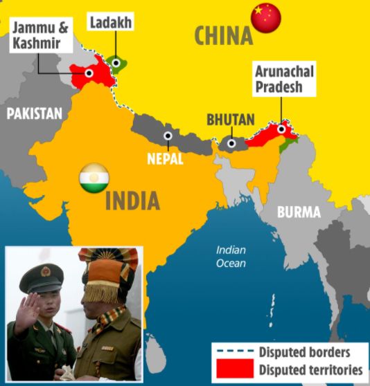
The Ladakh region is
especially complex, with particularly unusual features. First, there is Aksai
Chin, a territory that India has long claimed, but China occupies. China
began building
a road through the area in 1956, linking Tibet to Xinjiang, and
has occupied it
since 1962. There is also a territory that Pakistan ceded to China in 1963.
Surveying and mapping the region’s terrain historically, as we have seen, proved immensely challenging.
Due to two books that
where published in 2020, a closer look has been
presented about what moved the final decision for China to attack India.
About The
North-East Frontier Agency (NEFA), as one of the
political divisions in British India and later the Republic of India until 20
January 1972, when it became the Union Territory of Arunachal Pradesh and some
parts of Assam.
Bertil Lintner in
China's India War: Collision Course on the Roof of the World
(2020), clarified why the nature of the dispute over the NEFA is very
different and distinct from that of the Ladakh sector. Even when New Delhi
extended its political and administrative hold on this region as early as
1950, Peking did not contest these steps, other than questioning the
validity of accepting the McMahon Line. Since Peking had never stepped into
this territory beyond the Himalayas before 1962, except for a short span of
time in 1910-1911, Chinese arguments regarding the NEFA were null and void. It
seems that, in the early years, China was particularly concerned only with
dismantling the colonial tag of the Simla Agreement
(the McMahon Line of 1914) and was not interested in staking any claim to the
territory beyond the south of the Himalayas. And that China had not
proposed any arguments until the Tibet issue became strong.
Ismail Vengasseri, in his book 1962 Border War: Sino-Indian Territorial
Disputes and Beyond (2020), similarly points to the Tibet issue.
Throughout the early
1950s, Peking pursued a vigorous phase of validating processes to reiterate its
claim to the area by secretly constructing a road. But it was only after 1958
when the Chinese road report in Aksai Chin came to the public knowledge. The
government of India's opposition pressure became stronger that New Delhi began
to protest Peking’s claim to Aksai Chin. So once the conflict became apparent
in this sector, China began to propose an extended territorial claim in the
eastern sector (the NEFA), which was a balancing act of sorts to win a better
bargain at the negotiation table. Thus, we can see a connection to China’s
extended claim in the NEFA with the developments for and against Aksai Chin in
the post-1958 period.
New Delhi’s efforts
to make cartographic changes in its maps in the western sector had not invited
any counteroffensive from the opposite side. Similarly, when China announced
the opening of the Aksai Chin road (1958) and showed a
significant portion of Ladakh and the NEFA as Chinese territory (1958), New
Delhi’s response was limited a protest note.1
By and large, New
Delhi did not emphatically stake a claim in the western sector until 1959, and
Peking’s anticipated move in the NEFA was also not different. But after 1959,
there was a change in the dynamics between nations. It was apparent that a
strong external factor had played a role since 1955.
The larger Geostrategic contest
Particularly Vengasseri is keen to point out that the shadow presence of
the CIA in the troubled Indo-China border regions and support to the Tibetan
rebels in the form of money, materials, and other logistics, in addition to
arms training for the rebels, are facts that have been well documented2 by
reliable sources who had worked for the same objective. The CIA had already
crept into the political and bureaucratic veins of India and had established
itself as a determining factor within native politics3 and, as it had
desired, played a role in the border dispute as well. This, naturally, was a
major concern for Peking, while it did not much perturb
New Delhi. In this context, the border dispute must be seen rather than a mere
tussle between New Delhi and Peking. Chinese officials said, ‘China can
only concentrate its main attention eastward of China, but not south- westwards
of China, nor is it necessary for it to do so.’4 What does this actually mean, and what was the real context of such a
statement.
The tectonic changes
in Sino- Indian relations in the post-1959 period emanated not solely from
their boundaries. Such a drastic change would neither be confined to minor
skirmishes on the frontiers alone.
No doubt, the Panchsheel Agreement was a milestone in Sino-Indian
bonhomie, and the world looked at it with great hope and admiration and had
been considered Nehru's success in the Third World. However, in the Cold
War's backdrop, this move was not admired in the Western world. When the World
War changed global power equations, Great Britain’s weakness provided a space
for the USA to position itself as a hegemonic power in the Asian
continent. While the unity of the Third-World nations brought with it hope
and aspirations for the newly independent colonies of Asia and
Africa, Washington was against the US hegemonic aspirations in Asia.
The USA's continued efforts to reach out to New Delhi were still not
successful due to Nehru's policy of non-alignment. In the context of an
existing post-World War Red Scare in the USA called ‘McCarthyism’ and intense
indignation of Washington against Peking out of the Korean crisis brought the
US attention to the Himalayas. The Tibet issue, a creation of imperialist
Britain, was taken up by the USA as the potential ‘weapon’ to strike Communist
China. It was tactically placed between India and China to play a larger
game in the region. Washington found an existing border dispute between India
and China as the entry point to intervene in the region. The USA wished to
target India and China, the two most powerful nations in Asia. After
signing the 1954 Panchsheel Agreement with China,
Nehru focused his attention on the Non-Aligned Movement.
The 1954 treaty that
had asserted mutual respect between China and India on territorial integrity
issues and sovereignty wrongly assumed that both sides shared the same idea of
those territories. That same year the Government of India revised its official
maps that showed “undemarcated” or “undefined”
borders in Ladakh to show a definite border, a composite line of the Johnson
Line of 1865 and the 1899 Macartney-MacDonald Line based on no additional
surveying or demarcation.5 This was, in Jawaharlal Nehru’s estimate, the
simplest way of dealing with the continued borderlessness
inherited from the British across much of the Himalaya. But when
Bakula Rinpoche visited western Tibet in the summer of 1957, he reported
to the Indian government that the Chinese military had been constructing a road
across the uninhabited Aksai Chin plateau Xinjiang and Tibet. Sino-Indian
relations were made even worse when, in 1959, India received the Dalai Lama,
who had fled an uprising in Lhasa and was subsequently followed into exile by
nearly one hundred thousand Tibetans. And a series of incidents between Indian
and Chinese soldiers and officials in the northwestern and northeastern
Himalaya began to push Indian public opinion against China. In 1960, Nehru and
his Chinese counterpart Zhou Enlai held meetings in an
attempt to de-escalate tensions. They ended when China and India
disagreed on the major watershed that defined the boundary in the western
sector. Indian claims clung to the major watersheds of the Himalayas, while China’s
did not.6 War broke out in October 1962.7
According to Bertil
Lintner, rather than India provoking China, it could be argued that China's new
communist leaders who had behaved aggressively after they seized power in 1949.
In 1950, they sent thousands of troops to invade Tibet, a de facto independent
nation. And argues
that long before the 1962 war, China had hardened its position against Nehru
and prepared itself militarily.
Today frequently
quoted the Henderson Brooks-Bhagat Report written after the war is said to have
noted that the Army General Staff had failed to apprise the government of the
inability to effectively support a “forward policy” in Ladakh and the North-East
Frontier Agency (NEFA), a policy largely inherited from the British.8 Whereby
Lintner writes that: 'In essence, the Henderson Brooks-Bhagat Report states
little more than that India was ill-prepared for the war and therefore unable
to withstand the Chinese assault over the Himalayas. It also points out
weaknesses in India’s command structure, and the lack of effective cooperation
between the government and the military. It certainly does not say that India
was responsible for the war, nor does it question the Forward Policy per
se.'
Two months after the
war’s end, on Republic Day 1963, Lata Mangeshkar brought Nehru and many others
to tears singing for the first time “Aye Mere Watan Ke Lōgõ”
(“Oh, People of My Country”): When the Himalaya was injured and our freedom was
threatened, they fought right to the end and then they laid down their bodies …
some were Sikh, some Jath, and some Maratha, some were Gurkhas and some Madrasi. But each brave man who died on the border was an
Indian, the bloodshed on the mountains, that blood was Indian.
The mountainous
Himalayan border (sarhad) was made Indian by the spilling
of blood on it. The border was now something for which one gave one’s life.
This national consecration of India's frontline added to policies that sought
to establish a fixed and inviolable sense of national territory. A year
earlier, for instance, Nehru had “made it a crime to question the territorial
integrity of India,” as the Indian state continued to shore up its territory
through the annexation of the Portuguese colony of Goa.9
The Sino-Indian War
of 1962 marked the point at which, for the first time, a border was effectively
established on the ground in the northwestern (and the northeastern) Himalaya.
This “Line of Actual Control”—distinguished from the “Line of Control” (LOC) to
the west, running through Pakistan- and Indian-occupied Kashmir—has been a
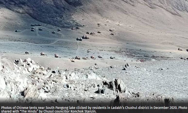
source of tension ever since. In the summer of 2017,mentioned
above, a months-long standoff at the Doklam plateau in the central Himalaya and
a particularly violent clash between Chinese and Indian soldiers along Pangong
Lake banks in Ladakh threatened to escalate into a full-scale border war
between the two nuclear powers. Uncertain borderlines and the insistence on
“territorial inviolability” are once again to blame. The power held by these
spatial-political ideas radiates far beyond the sparsely populated and
mountainous regions involved. The Himalaya continues to play a two-fold role,
both as a defensive wall and a potentially dangerous conduit at the center of a
decades-long Sino-Indian stand-off. Indian representations of the border
dispute often paint China as the aggressor, even while acknowledging
possibilities of reconciliation between the two counties.
Unlike the newly
minted postcolonial “lines of control,” the general acceptance of border points
had long existed in the Himalayas. Typically located on established trade and
pilgrimage routes, these points served as means for
signaling seasonal customs duties to be paid, or corvée labor to be given. But
a complete borderline through such mountainous country came into political play
only when maps and geographically based logics began to hold greater authority
as tools of territorial control. This authority can be seen in the evolving
colonial concept of the ideal border: a concept based on “natural” principles,
implemented by scientifically sound practices and represented on increasingly
classified maps, as well as in systematic manuals of governance such as the
district-level gazetteers. But these principles and geographical practices
ultimately produced more confusion than solutions. Each proposed line failed to
establish a border until the unilateral Chinese ceasefire on 21 November 1962.
The vast space of the
uninhabited and inhospitable corner of the northwestern Tibetan Plateau now
generally referred to as the Akai Chin was thus anything but empty. It has
become an intimate part of the spatial self-conception of India. However, it
has become a specific place only to the unfortunate
soldiers tasked with maintaining a presence there. In this sense, then, the
region remains a utopia (literally: “no place”), a spatial idea off-limits to
all but a few military personnel, but highly visible in the geospatial
imaginary of India.
Rendered on maps that
no longer showed indeterminate borderlessness, the
region that once formed the center of a vast cultural and commercial network
was, by the end of 1962, a borderland by the imposition of a de facto
borderline. Despite repeated attempts to articulate a scientific and precise
rationale based on the Indus watershed, the “Line of Actual Control” fails to
reflect any particular geographical principle. There
was no linear path to producing this borderland, but instead a series of ideas
of how peripheral political space ought to be organized through the region's
natural features. While these ideas proved rather futile in shaping the Line of
Actual Control, they were potent in shaping a worldview that viewed
international politics as a competition between abutting territories determined
by, and dependent on, geography. It is one of the great ironies of the history
of frontiers and border making that the mountainous laboratory that seemed to
offer such a clear means of defining a “natural” frontier should instead
consistently fail to yield a legible border. Holdich’s
“finest natural combination of boundary and barrier” had proven to be anything
but.10
By placing
mountainous, sparsely populated, and increased peripheral spaces like Ladakh
and the North-East Frontier Agency on the frontline of government policy, the
Indian government was following established imperial practices.
First, India's
government maintained the importance of the idea of the border as a sine qua
non of territory. The border, with its security risks and threats of foreign
penetration, became a frontline. As the outline of the geo-body of the nascent
independence state, the borders enclosing the territory claimed by India became
quickly tied to swelling nationalism. Unlike the managed frontiers and borders
of the British Empire, which tolerated a degree of ambiguity, the
nation-state's borders were essential constitutive elements of the
nation-state. Borders became something to die for. The violation of India's
geo-body in its two remote Himalayan extremities in the Sino-Indian War had a
deep impact on India’s sense of nation. It is an often-repeated
saying that when Nehru died in 1964, he died of a broken heart over India’s
humiliating defeat and loss of territory to China.
Second, the
geopolitical calculus that brought Ladakh to Nehru’s attention was the product
of decades of practices surrounding transforming frontiers into borders. By the
end of the nineteenth century, individual frontiers had become integrated, in
policy rhetoric at least, into a single “frontier policy.” Gazetteers continued
to be one of the district's principal information tools- and state-level
governance following independence. Border roads have become so explicitly tied
to security concerns that the Border Roads Organization exclusively manages
them, a branch of the Indian Ministry of Defense. And border maps are highly
regulated. These practices rooted in the colonial era were bequeathed to India
and have formed the basis of its approach to its borders for decades.
And so what about today?
Since 1962, both
India and China have invested huge military resources in assuring that this
desolate region once only crossed by traders and pilgrims is now occupied by
thousands of soldiers facing off across a line whose only logic lies in an
appeal to a vague colonial description from a series of equally vague maps.
Today, taken as a fractured whole, Jammu and Kashmir State represents one of
the most militarized spaces in the world, “the vulnerable neck and head of
India,” as one political commentator recently put it.11 This body metaphor is
particularly telling considering the frequency with which maps are conflated
with bodies.
There is no clear
reason exactly why tensions have escalated now to their worst in decades, with
the first fatalities in forty-five years. And New Delhi and Beijing hold very
different views of what happened the night of June 15.
India pointed to “premeditated” Chinese action that “reflected an intent to
change the facts on the ground in violation
of all our agreements not to change the status quo.” China said that
“Indian frontline border forces openly
broke the consensus reached.”
China’s moves are
hard to gauge, and as scholars have noted,
India’s options are limited. Modi said in his 17 June 2020 address that India’s
“sovereignty is supreme,” indicating that accepting a territorial shift in
China’s favor likely will not be his next step. But looking for conflict at a
time of economic downturn and still-rising coronavirus cases is not a good
option, either. New Delhi will likely assess other nonmilitary policy options.
The blanket calls to boycott
Chinese products have gained some mass appeal in India. Still, the
government may take further steps, such as increasing scrutiny on inbound
investment from China, similar to the Committee on
Foreign Investment in the United States (CFIUS) review process. India
recently announced
review procedures for foreign investment from “neighboring” countries,
and this net could expand further. China is a source of investment in
some of India’s top start-ups. And press reports have already identified forthcoming
restrictions on Chinese equipment in India’s large and growing telecom
sector, including a likely ban on Chinese companies’ involvement in building 5G
infrastructure.
Despite long-standing
border tensions, the two giants have significant multilateral cooperation,
including through alternate global institutions created over the past decade.
The BRICS bloc, comprising Brazil, Russia, India, China, and South Africa; the Asian
Infrastructure Investment Bank (AIIB), in which India is the second-largest
capital contributor; the New Development Bank; and the Shanghai Cooperation
Organization, which India recently joined, have all been arenas for cooperation
despite the countries’ ongoing security competition. But with escalating
security tensions, New Delhi may reexamine its level of interaction in other
areas.
Nevertheless,
the Chinese PLA incursions in eastern Ladakh and the massive military
build-up by both sides currently resulted in the most
explosive situation on the LAC in over 50 years.
There have been
multiple attempts at disengagement and de-escalation on the disputed border,
but the political and military talks, the last one was held on 6 Nov., have
been futile. The Chinese have refused to restore the pre-May status quo in
Ladakh, where they now control an additional 600 square miles of territory.
Indian and Chinese
battle tanks are positioned only a few yards apart at standoff sites, while
more than 100,000 soldiers of both armies remain deployed at altitudes ranging
from 10,000 to 15,000 feet, where temperatures can dip to minus 22 degrees
Fahrenheit.
Recognizing that
Beijing has an immense military advantage, New Delhi has chosen a path of
levying economic punishments, such as the banning of Chinese-origin apps and
restricting Chinese participation in government procurement. But India’s
limited economic leverage over China has rendered these measures relatively
ineffective. Even though New Delhi made certain bold military moves on its side
of the so-called Line of Actual Control, the de facto border, in late August,
it has been careful to avoid any serious military escalation or initiate a
limited war with Beijing. As South Asia’s worst-performing economy in
2020, India is not in a position to bear the cost
of a military conflict. As South Asia’s worst-performing economy in 2020, India
is not in a position to bear the cost of a military
conflict. A war with China would also force India to discard its long-standing
policy of strategic autonomy, as New Delhi would have to make the politically
unpalatable choice of openly allying with Washington.
Having ruled out a
quick resolution through conflict, India’s only viable option has been to go
for a long and drawn-out border standoff against the Chinese.
And according to a
recent article in Foreign Policy: In off-the-record conversations, Indian
officials accept that a diplomatic solution to the Ladakh crisis is unlikely
because of how the two countries have different understandings of the status quo.
These officials consider the army’s performance and sustenance through this
winter as the critical factor for their plans to deal with Chinese aggression
in Ladakh. They contend that if the Indian soldiers manage to get through the
next few months relatively unscathed, New
Delhi will have found an answer to its troubles with Beijing.
In part one we see
how mapmaking by both the British and the Chinese showed the growing
concerns over-penetration from beyond the frontier by transfrontier groups,
the need to gather and restrict trans-frontier information, and the imperial
preoccupation of determining the lines that would mark the imperial perimeter
reflected a broader change in how geography and the
state functioned together.
In part two we detail
how the legacies of the 1962 war continue to
shape our perceptions.
1. Note to the
Counsellor of China in India by MEA, 21 August 1958 (White Paper,
1954-1959), 46.
2.
Kenneth Conboy and James Morrison, The CIA's Secret War in
Tibet, 2002.
3. L
Natarajan , American Shadow over India, 1956.
4. Statement Made by
the Chinese Ambassador to the Foreign Secretary, 16 May 1959 (White Paper
I, New Delhi: MEA).
5. Lamb, The Sino-Indian
Border in Ladakh. 70.
6. See Woodman,
Himalayan Frontiers: A Political Review of British, Chinese, Indian, and
Russian Rivalries.
7. For the history
leading up to the Sino-Indian War, see, for instance also: Lamb, The
China-India Border: The Origins of the Disputed Boundaries., Asian Frontiers:
Studies in a Continuing Problem (New York, Washington, and London: Frederick A.
Raeger, 1968), and The Sino-Indian Border in Ladakh
(Canberra: Australian National University Press, 1973); Fisher, Rose, and Huttenback, Himalayan Battleground: Sino-Indian Rivalry in
Ladakh; Woodman, Himalayan Frontiers: A Political Review of British, Chinese,
Indian, and Russian Rivalries; Maxwell, India’s China War; John Lall, Aksaichin and Sino-Indian Conflict (Ahmedabad: Allied
Publishers, 1989).
8. The first volume
of the report was published on the personal website of the Australian
journalist Neville Maxwell, who had used much of the leaked document to write
his 1970 book, India’s China War. Whereby Lintner counters this by writing
that: I came to realize that Maxwell’s version of the events leading up to the
1962 War did not stand up to any serious scrutiny. First of all, Nehru’s
Forward Policy, which was designed to secure the entire Sino-Indian frontier
from Ladakh in the west to the North-East Frontier Agency (NEFA; an
administrative unit under the government of Assam and now the Indian state of
Arunachal Pradesh) in the east, was decided upon at a meeting in New Delhi on 2
November 1961, less than a year before the war. Nehru chaired the session,
which was also attended by Defence Minister Vengalil Krishnan Krishna Menon, head of the Intelligence
Bureau, Bhola Nath Mullik, Foreign Secretary M.J. Desai, and the then newly
appointed Army Chief of Staff, General Pran Nath Thapar.
9. The quote is from
Pankaj Mishra, “India at 70, and the Passing of Another Illusion,” The New York
Times, August 11,
2017, https://www.nytimes.com/2017/08/11/opinion/india-70-partitionpankaj-mishra.html?_r=0.
10. Thomas
Holdich, Political Frontiers and Boundary Making,1916, 280.
11. Saba Naqvi, “One
Point Five/Two: Jharkhand Has Been Mined, Jammu-Kashmir Is Still a Prospect,”
Outlook, January 12, 2015, 18. 57 As Joya Chatterji has noted regarding
Partition, surgical metaphors are often invoked to describe the territorial
changes to the “geobody” of the anthropomorphic
nation.
For updates click homepage here