By Eric Vandenbroeck and
co-workers
Xi Jinping's Ready For War Speech
Recently Chinese
President Xi Jinping has called on troops to "put all (their) minds and
energy on preparing for war" in a visit to a military base in the southern
province of Guangdong according to state news agency Xinhua.
This came shortly
after Beijing increased military drills around Taiwan. Almost 40 Chinese
warplanes crossed the median line between the mainland and Taiwan on 18-19
September, one of several sorties the island's President Tsai Ing-wen
called a "threat of force."
After years of the
United States and China butt heads over trade and other issues, opportunities
for a mutually constructive rapprochement are growing scarce. It will be up to
Joe Biden's administration to develop a more cogent strategy for dealing with the most important foreign-policy issue of this
century.
In a recent statement
referring to the Taiwan problem, China speaks of 'peaceful' yet at the same
time insist ("China
will resolutely deter") that Taiwan cannot strife for independence and
more importantly insist Taiwan become part of mainland China (using the term
'reunification') something Taiwanese absolutely do not want especially after
they see what is happening with Hong Kong.
This whereby Taiwan's President Tsai Ing-wen accurately
stated that Taiwan de-facto is already
independent.
When the United
States severed relations with Taiwan (that time the Republic of China) in 1979
and discarded its mutual defense treaty with the island, Congress passed
the Taiwan Relations Act, which made clear that the United
States maintained special commitments to Taiwan. The TRA asserted that the
United States would “consider any effort to determine the future of Taiwan by
other than peaceful means, including by boycotts or embargoes, a threat to the
peace and security of the Western Pacific area and of grave concern to the
United States.” It also stated that the United States would both maintain the
capacity to come to Taiwan’s defense and make available to the island the arms
necessary for its security. Importantly, however, the TRA did not declare that
the United States would in fact come to Taiwan’s defense.
American ambiguity
however worked to deter China from attacking Taiwan, as Beijing could never be sure what the U.S. response would be.
As Joseph S.
Nye, Jr. recently argued in What Could Cause a US-China War? The US will
retain some long-term power advantages that contrast with areas of Chinese
vulnerability. One
is geography. The US is surrounded by oceans and neighbors that are likely
to remain friendly. China has borders with 14 countries, and territorial
disputes with India, Japan, and Vietnam which set limits on its hard and soft
power.
Following is an overview of the wider background that
led up to the current situation.
Geography and the construction of today's China
As we early on have
seen, it was during the late Qing Dynasty and the early Republic of China that
became the formation stage of modern Chinese nationalism and the stage of the
proposition and initial usage of the concept of 'the Chinese nation' first came
in Use. To be more precise modern Chinese nationalism developed around the period of the May 4th Movement during
the time of the Left and Right New Culture
Movement. And although Mao Zedong in March 1953 still referred to
"Han chauvinism" to criticize his rival
Kuomintang party, this drastically changed following the CCP's 1989
Tiananmen crackdown.
That is, where the
anti-Mao Guomindang/KMT leadership deliberately used fear of the loss of
territory in the 1920s and 1930s to rally political support, communist party's
(for reasons we described) Deng Xiaoping re-introduced the Guomindang's “one-hundred-year history of humiliation” narrative as a new source of legitimacy of the CCP’s
rule and the unity of the 'Chinese' people and CCP society. This was crowned by
a new ongoing yearly
National Humiliation Day.
In February 2019, the
Chinese government (CCP) also issued specific rules covering the printing
within China of maps in books or magazines intended for sale in overseas
markets. Each map would require permission from provincial officials and none
would be allowed to be distributed within the country. The possibility that a
Chinese citizen might see a map showing an unauthorized version of China’s
territorial claims was perceived as such a threat to national security that it
justified the involvement of the National Work Group for Combating Pornography
and Illegal Publications’, according to the regulations.1 To prove the point,
in March 2019 the authorities in the port city of Qingdao destroyed 29,000
English-language maps destined for export because they showed Taiwan as a
separate country.2
As we pointed out the
story of how certain current Chinese territories came to be regarded as ‘rightfully’ Chinese while others did not is
far from simple. During the twentieth century, some areas that were held to be
‘natural’ parts of the country, such as Outer Mongolia, were let go while
others that had been abandoned, notably Taiwan, were reclaimed. When the Qing
Empire collapsed in 1911, most of its borders were more imaginary than real.
Except in a few places, where Russian, French or British empires had forced
them to be demarcated, they had never been formally defined. In the decades
after the revolution, the national elite in Beijing had to ‘fix’ a national
territory for the first time. This was a process that had to take place on the
ground but also in the national imagination. Maps had to be drawn but, just as
importantly, the world-view expressed on those maps had to be inculcated in the
minds of the people. Anxiety about the vulnerability of those borders was
deliberately generated, right from the beginning. There were fears of foreign
threats but there were also expansionist dreams and political calculations.
Enter the China trade
As we have described the history of Chinese foreign
trade began as early as the Western Han dynasty when the famous "Silk
Road" (although that term was only later on coined
by Carl Ritter 1838 and popularized by Sven
Hedin in the 1930s) as a later symbol for trade
through Central Asia was pioneered by Chinese envoys.
Then in the
middle of the seventeenth century in the wake of Matteo Ricci who was the
first westerner to enter the forbidden city in 1601, gradually statesmen and
scholars all over Europe started to look at China as a beacon of commercial,
intellectual, and cultural potential, offering the promise of wealth as well as
global civilizational convergence.3
Later in the spring
of 1843, after a number of lively and often heated debates, the United States
Congress approved funds for the first US mission to China. President John Tyler
spoke of the mission as one of great "magnitude and importance“4 and
Secretary of State Daniel Webster called it "a more important mission than
ever proceeded from this Country, and more important mission than any other,
likely to succeed it, in our day.“5 Indeed, this mission, led by former
congressman Caleb Cushing, resulted in the first US treaty with China (the
Treaty of Wangxia,1844), which secured trading privileges for American
merchants and opened a host of Chinese ports to serve as outlets for surplus
American production. Contained within the treaty was also the first appearance
of a most favored nation clause-inserted in order to assure the US of the same
privileges in China as might be granted any other nation. The impetus for this
mission was the threat of the British monopoly of the Pacific markets. American
rivalry with Britain for the markets and influence in the Pacific forced US
politicians and bureaucrats to assume a positive role in East Asia in the early
1840s.
Russia posed a
similar threat to US designs of spatial order and regional hegemony. Moving
east across Siberia, Russians attempted to access Japan and the Pacific from
the north.6 Russian territory already stretched to the North Pacific, which
posed a particularly dire threat to the US. As Hawks wrote: "There is no
power in the other hemisphere to which the possession of Japan, or the control
of the affairs, is as important as it is to Russia. She is on one side of the
islands, the United States on the other. The Pacific ocean is destined to be
the theatre of immense commercial undertakings...with such harbors on the
Pacific as Japan would give her, she might hope to become the controlling
maritime power of the world.7
Like the
treaty of Wangxia, the opening of Japan by Commodore Matthew C. Perry in 1854 stands as a focal point of early US
foreign policy. The Perry's mission aimed at and succeeded in throwing open an
isolated Japan to the commerce of the world convinced Japan to welcome
shipwrecked sailors and laid the grounds for a merchant base to access the
China market. As the US worked to reinvent interaction with Asia in terms of
the Pacific trade running through the American continent the incorporation of
the Japanese islands into the global commercial system by Americans' own design
strengthened the US hand. Unlike the case of China however, the US initiated
the first treaty with Japan and thus set the terms by which this Asian country
would interact with the world. This not only gave American merchants an
advantage of primacy but also allowed the US to shape the relationship to its
liking and gain greater control over the Pacific and the Pacific markets.
Having watched
Britain take the initiative in China and American merchants gain a stronger
foothold in that market, Russia could not allow either the US or Britain to
gain as much influence in Japan as they did in China and moved accordingly to
outdo the Perry mission and attempted to open Japan first. On October 19, 1852,
the Russian expedition sailed in an attempt to beat the US to Japan. They
arrived in the fall of 1853, right after Perry had paid his first visit and
gave Japan the ultimatum.8 Having failed to beat Perry to Japan, the Russians
actually succeeded in inciting the American Commodore to move quicker to press
for and conclude treaty negotiations lest the Russians "interfere very
seriously with my operation," Perry wrote in his journal.9 Hawks
reemphasized this point: "The Commodore, suspecting that the Russians
contemplated the design of returning to Japan and of ultimately going
to Yedo, which might seriously interfere with his operations, induced him
to alter his plans.“10 So Perry sailed sooner rather than later, and Russia
ended up negotiating and signing a treaty with Japan a year later (1855),
opening three ports to Russian trade.11
China's new geographers
Generally speaking
the story of the invention of present modern China’s territory, and its
territorial anxieties, as we have seen can be
said to have its beginnings in the aftermath of the first world war and with the
arrival of the Western science of geography. It ends with the rediscovery of
Taiwan, its reconnection with the mainland, and then its separation.
The last major piece
of territory to be formally renounced by the Qing court the Treaty of
Shimonoseki (Japanese: 下関条約, also
known as Treaty of Bakan (馬關條約; Mǎguān Tiáoyuē) was signed away on 17
April 1895. The treaty that Li Hongzhang (also romanized as Li Hung-chang;
1823 –1901 Chinese politician, general, and diplomat of the late Qing
dynasty) agreed in the Japanese port of Shimonoseki ceded
Taiwan, and the Pescadores Islands off its coast, ‘to Japan in perpetuity
and full sovereignty. Just over a month later, the acting governor of the
island, a mainlander, and a few other officials and merchants declared
independence in the name of the Taiwan Republic’ rather than submit to Japanese
rule. They hoped to elicit support from Britain and France but the Europeans
saw no advantage in intervening and the Republic collapsed just eleven days
after being declared.
Throughout this long
campaign, the Qing court declined to offer any support to its former subjects
in its former province. In fact, material support for the rebel Republic was
explicitly banned by a court edict in May 1895.12
Thus in the aftermath
of the treaty-signing, Qing officials almost entirely ignored developments in
Taiwan. The island was lost, in the same way that other pieces of territory
signed away by other treaties had been lost. In 1858 the Qing had ceded 500,000
square kilometers of land north of the Amur River to Russia through the Treaty
of Aigun.13 They had then been forced, through other ‘unequal treaties’, to
allow European powers to establish micro-colonies all around the coast. Taiwan
appeared to have gone the same way; there was no feasible way of wresting it
back from Japan’s clutches. The 2 million or so Qing subjects on the island,
mostly speakers of the Hokkien and Cantonese topolects, along with the
aboriginal population became colonial subjects of Japan.
Surprisingly,
perhaps, the same insouciance about Taiwan’s fate also characterized the
revolutionary movement. Sun Yat-sen and his comrades
made no demands for the return of the island to Qing control. At no point, so
far as we know, did Sun concern himself with the resistance to Japanese rule,
even though it continued to smolder. For Sun, Japanese-controlled Taiwan was
more important as a base from which to overthrow the Qing Dynasty than as a
future part of the Republic. We can see this in his behavior during 1900. That
year, Sun left Japan and traveled around Southeast Asia seeking support for a
planned uprising in Guangdong province. He was disappointed: neither the
established reformists nor local community leaders took him seriously. Instead,
when Sun returned to Nagasaki he became part of a Japanese plot to seize the
port of Amoy (modern-day Xiamen). Under Tokyo’s patronage, Sun based himself in
Taiwan and ordered his revolutionary forces to mass around their main support
base in Guangzhou. But, in a typically rash move, Sun changed the plan at the
last minute, diverting the fighters to Amoy, where he intended to join them
accompanied by a shipment of Japanese weapons. The Japanese, however, had
become concerned about provoking a Russian reaction and backed out of the
entire scheme. Sun’s rebel force found itself isolated and outgunned and was
destroyed.14
Despite the betrayal
in Amoy (modern-day Xiamen) when the Japanese had become concerned provoking a
Russian reaction and backed out, Sun continued to regard the Japanese
government as his main sponsor, and the revolutionary movement continued to
ignore the issue of Taiwan. The reformists had little interest in the island,
either. When a leading Taiwanese activist, Lin Xiantang, met Liang Qichao in Japan in 1907, Liang advised him
not to sacrifice lives in opposing Japanese rule since the mainland would not be
able to help. Since neither could speak the other’s topolect, Liang had to
communicate with Lin through ‘brush talk.’ This only made Liang’s message more
poignant: ‘(We were) originally of the same root, but are now of different
countries.’15 The Qing court, the revolutionaries, and the reformists all took
the same view: Taiwan had been ceded by treaty and lost to China. It seems
remarkable, given the passion that the island’s political status generates
today, but the island virtually disappeared from political discussions in the
decade before the revolution of 1911/12. Even after the revolution, when Sun
had no more need for Japanese support, he and his supporters continued to
ignore Taiwan's fate.
From the patriotic education movement to the new
Taiwan story
In a similar vein as
above, in his speech on ‘The Anti-Japanese Resistance War and the Future of Our
Party,’ Chiang Kai-shek argued that, ‘We must enable Korea and Taiwan
to restore their independence and freedom. Even more so, Mao's Communist Party
had long supported independence for Taiwan rather than reincorporation into
China. At its sixth congress in 1928, the Guomindang party had recognized the Taiwanese as a separate
nationality.
In May 1928, just
after the establishment of the Guomindang’s ‘National Government’ in Nanjing,
the party convened the ‘First National Conference on Education.’ The conference
resolved to adopt a new national curriculum for schools based upon Sun Yat-sen's
Three Principles of the People’: Nationalism, Democracy, and People’s
Livelihood. Within months, the GMD had captured Beijing and very quickly set
about imposing a new ‘temporary curriculum’ nationwide. From 1929 all schools
were expected to imbue their pupils with strong feelings of patriotism,
mobilized in particular through the teaching of history and geography.16 Pupils
were expected to study the various regions of the country, ‘in order to foster
the national spirit.’
A major contribution
to this patriotic education movement was the series of textbooks written
by Chang Ch‘i-yün who graduated from the Division of History and Geography
of National Nanjing Higher Normal School (later renamed National Central
University and Nanjing University) where he was a student of the first
Chinese geographer Zhu Kezhen.
In 1928 the
Commercial Press published one as Benguo Dili, ‘Our Geography.’ Its key message
was that China formed a natural unit despite its enormous size and variety.
Using his geographical training, Zhang divided up the country into twenty-three
‘natural’ regions based on their environments and the inhabitants’ ways of
life. He then compared them, telling pupils that, for example, the Yangtze
Delta was good for farming but had no minerals; Shanxi was rich in coal but too
dry for agriculture; Manchuria was forested while Mongolia was good for
grazing, and so on. He then told the young learners that this diversity was
actually proof of the need for national unity since each different part was an
essential part of a coherent whole.17
Yet the ‘whole’ that
Zhang portrayed in the textbook was a territory that, in reality, did not
exist. The book contained various maps of the country drawn on blank
backgrounds so that the rest of the world disappeared from view. The simple
black line marking the national boundary encompassed huge areas that were not
actually under the government's control: the independent states of Mongolia and
Tibet. Zhang portrayed them as a natural part of the Republic, nonetheless. How
reality would be reconciled with the map was not explained to the pupils.
Remarkably, given present-day politics, there was a significant omission:
Taiwan was not drawn in any of the textbook's national maps. It seems that, in
Zhang’s view, the ‘natural’ shape of the Republic was exactly the same as the
shape of the Qing Empire at its collapse in 1911. Mongolia was included; Taiwan
was not. The rocks and reefs of the South China Sea did not feature at all.
Zhang spent the next
four years writing the geography textbooks used in most Chinese schools during
the later 1920s and beyond. But while dozens of geography textbooks were
printed during the 1920s and 1930s, and they all ignored Taiwan while stressing
the importance of Mongolia and Tibet. Zhang himself, in another textbook he
co-wrote in 1933, Waiguo Dili, ‘The Geography of Foreign Countries’, described
the people of Taiwan as ‘orphans’ deserted by their birthmother, the Chinese
nation Zhonghua minzu, and abused by their stepmother, Japan.
Zhang, and the other
authors of these books, faced a problem that was both pedagogic and deeply
political. How could they persuade a child in a big coastal city, for example,
to feel any connection with a sheepherder in Xinjiang? Why should they even have
a connection? The general purpose of human geography was to explain how varying
environments had created groups with differing cultures. However, nationalism
required all these different groups to feel part of a single culture and loyal
to a single state. It was up to nationalist geographers to resolve the puzzle.
They found two main ways to do so. One group of textbook authors simply stated
that all Chinese citizens were the same: they were members of a single ‘yellow’
race and a single nation, and no further explanation was needed. However, a
second group acknowledged that different groups did exist but were nonetheless
united by something greater. Within this group, some authors made use of
‘yellow race’ ideas, some used the idea of a shared, civilizing Hua culture,
while others stressed the ‘naturalness’ of the country’s physical boundaries.
The textbook writers
argued that the answer to the 'border question’ was to ‘civilize’ the
inhabitants. One, Ge Suicheng (who was employed by the rival, but equally
nationalistic, Zhonghua Publishing Company), found himself facing the same
dilemma as the Guomindang government. Both needed to emphasize all ethnic
groups' theoretical equality while simultaneously making a case for their
melding into a single Chinese nation based on ‘Han’ culture. In Ge’s view, the
study of geography should make the different peoples of the state love their
particular home areas but also connect them emotionally to the wider national
territory. But in the meantime, in the words of his textbook, ‘We should
urgently promote the acculturation of the Mongols, Hui [Muslims] and Tibetans
so that they are not lured by the imperialists, [and we should] move [Han]
inhabitants to the border areas for colonization...’
Zhang Qiyun’s 1928
textbook was also deeply imprinted with racial chauvinism. One part of the
book’s message to its millions of young readers was that the country was on a
journey from barbarism to civilization and that the wild frontier, where the
minorities lived, needed to be tamed and developed. The book included a table
of various ethnic groups showing how assimilated they were to the ‘main body’
(zhuti) of the Han. In a description of the southwest Miao people, Zhang wrote,
‘They maintain the customs of great antiquity and are totally incompatible with
the Han people. Eliminating their barbarism and changing their customs and
habits is the responsibility of the Han people.’ For Zhang, the Han provided
the ‘norm’ against which the other groups needed to be measured in order to
judge their level of civilization: they had to be made ‘Han.’ He shared Zhu
Kezhen’s opinion that climate was the determining factor in the spread of
civilization. In his 1933 textbook, he observed that in southwestern Yunnan province,
the native population lived in the hot and humid lowlands while the Han people
(Han-ren) lived on the cooler plateaus. On the other hand, in the mountains of
the northwest, the Han lived in the valleys where it was warm while the natives
lived at altitudes where it was colder. It was only natural, therefore, that
the ‘temperate-dwelling’ Han-ren, free of ‘degenerating’
environmental influences, should exert their influence over the minorities, the
tu-ren.18 Other textbooks made the same point, stressing Sun Yat-sen’s
arguments that the Han made up 90 percent of the country’s population and that
it was only natural that the other groups would assimilate.19 An idea that, as
pointed out by me in Jan. 2018 is
very present also in Xi Jinping’s repeated promise of “the great rejuvenation
of the Chinese nation.”
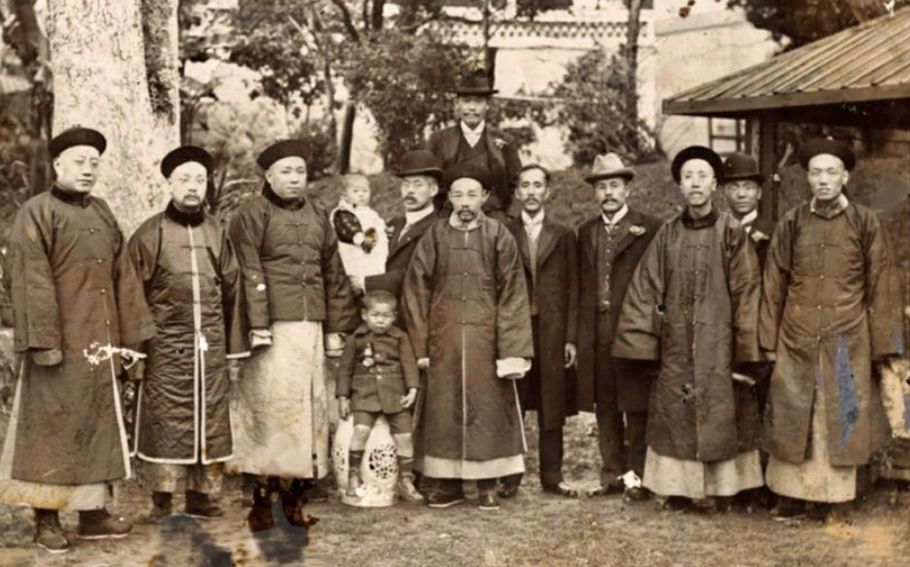
Underneath the
diplomat and poet Huang Zunxian (center) with some of his family. He
was one of the pioneers of the ‘yellow race’ thinking in the late Qing period
but later helped ensure the Hakka people were classified as part of the ‘Han
race.’
These arguments can
be traced back to those made by Liang Qichao a couple of decades before. Liang created
a story of continuity: the expansion of a civilized territory outwards from its
cradle in the Yellow River valley. The new geographers tried to write the
final chapter, its diffusion to the Republic's very edges.
The birth of the national territorial neurosis
An ever-present theme
in these textbooks was the threat of foreigners eating away at the country’s
edges. It was reinforced through school lessons about territory ‘lost’ during
the previous century. Teachers could use a peculiarly Chinese form of nationalist
cartography, the ‘map of national humiliation.’ Dozens of such maps were
published by the Commercial Press, Zhonghua Publishing, and other companies
during the 1910s, 1920s, and 1930s, sometimes within textbooks and atlases and
sometimes as posters for display in classrooms and public buildings. They are
typically portrayed in bright colors, land ‘conceded’ to neighboring states
over the previous century.20 There was a clear political purpose behind the
making of these maps. They served to delegitimize the Qing Dynasty, by
demonstrating its failure to ‘defend the country’ and thereby legitimize the
revolution. But they also deliberately generated a sense of anxiety about the
nation’s border's vulnerability to promote loyalty to the new Republic. It seemed
to work with a young Mao Zedong. He later told the American journalist Edgar
Snow that hearing about national humiliation made
him an activist.21 It wasn’t just Mao. This was the birth of the national
territorial neurosis.
The geographers took
the nationalist idea of ‘territory’, lingtu (領土 lǐng
tǔ), and projected it back to the time of ‘domain’, jiangyu (降雨 jiàng yǔ), when there were few fixed borders. A map
of national humiliation in Ge Suicheng’s 1933 textbook showed vast areas of
central Asia, Siberia, and the island of Sakhalin as territory ‘lost’ to
Russia. The map may have displayed different areas as ‘territory,’ ‘tribute
states,’ or ‘vassal states’ but all were categorized as inherently ‘Chinese,’
nonetheless. The idea that at the time they were ‘lost,’ these territories
might have been contested areas with no clear allegiance to any particular
empire was not part of the lesson. They were presented simply as ‘Chinese’
lands that had been stolen. Ge Suicheng called on the young citizens reading
his textbook to do what they could to recover all this lost territory. Did this
mean this ‘lost’ territory should be included within the state's rightful
boundaries, or not? Was the shape of the country at that time natural or not?
These questions were not even posed in the textbook, let alone answered. What
was important for authors like Ge was to encourage students to feel the sense
of loss, a collective sense of ‘national humiliation,’ and thereby develop a
patriotic attachment to the country. Anxiety about the territorial loss was a
fundamental part of the nationalist education project right from the beginning.
The anxiety was compounded because no one, not even the geographers, knew where
the borders actually were. The historian Diana Lary has shown how, in the
southwestern province of Guangxi, the border's exact line was almost
irrelevant. Although it had been formally agreed with Indochina'se French
colonial rulers in 1894, as far as the Republican officials were concerned, the
border was just somewhere in the mountains: high, remote, and difficult to
reach. The state had generally managed minority groups in southern highlands
through a system known as tuse, in which local leaders were held responsible
for their people’s actions.22 Borders were largely irrelevant. So long as they
didn’t trouble the authorities, the mountain peoples were generally left alone.
In Lary’s words, ‘The Chinese world stopped well before the
borderlands.’23 (Things would change. This is the same border that
thousands of Chinese and Vietnamese soldiers died fighting over in 1979.)
In 1928, the first
Chinese geographer Zhu Kezhen declared that Chinese cartography was about a
century behind its European counterpart. At the time, most of the publicly
available maps were still based on 200-year-old surveys from the early Qing
period. In January 1930, the government issued an official ‘Inspection
Regulations for Land and Water Maps’ (Shuilu ditu shencha tiaoli), instructing
the Ministry of Internal Affairs, the Foreign Ministry, the Marine Ministry,
the Ministry of Education, and the Committee of Mongolia and Tibet to work
together to regularise the country’s cartography. Nothing actually happened,
however, until 7 June 1933, when the official ‘Land and Water Maps Review Committee’ held its first
meeting.
The re-invention of Taiwan and the South China Sea
question
The man
who re-invented the South China Sea and caused China to claim
non-existent islands hundreds of kilometers from its shores was a Manchu who
probably never went to sea in his life. Bai Meichu was born into
relatively humble origins in 1876 in Hebei province, 200 kilometers due east of
the Forbidden City.
He became a
schoolteacher and then a teacher of teachers at the Women’s Normal School in
Tianjin. There he taught, among others, Deng Yingchao, a future senior
cadre in the Communist Party and the wife of Zhou Enlai. At the same time, he
was becoming a pioneer in the new subject of geography. This was not yet
geography as the later generation of the above-mentioned Zhu Kezhen, and
Zhang Qiyun would come to define it but a hybrid of old ideas and new
nationalism.
In 1909 Bai became
one of the ‘China Earth-Study Society’ (Zhongguo di li xue hui 中國地理學會#). According to the historian Tze-ki Hon,
none of its members had any professional training in the subject. Instead, they
recruited members from the old literati. Like Bai, they were people who had
once expected to join the scholar-bureaucracy but were now struggling to
adapt.24
Members of the China
Earth-Study Society were also profoundly influenced by Social-Darwinism. In the
first issue of their ‘Earth-Study Journal’ (Dixue Zazhi) they collectively
declared: ‘The cause [of the rise and fall of power] is due to the level of
geographical knowledge each group. Thus, the level of geographical knowledge
directly impacts a country, and it can cause havoc to a race. It is indeed [a
manifestation of] the natural law of selection based on competition.’ In other
words, the size of any group’s territory ebbed and flowed depending on its
relative civilization. In society's view, China had advanced early but then
retreated in the face of Western advances. The only way to regain strength was
to master geography. In the words of Bai himself in 1913, ‘Loving the nation is
the top priority in learning geography while building the nation is what
learning Geography is for.’25
Bai was the
first Chinese to draw a map of the South China
Sea in his New Atlas of China’s Construction in 1936 and have
been taught in Chinese schools since the 1940s while using a
British example.
Thus James Shoal
(off Borneo), Vanguard Bank (off Vietnam), and Seahorse Shoal (off the
Philippines) are drawn as islands, yet in reality, they are underwater
features. Almost none of the islands that Bai drew in the central and southern
parts of the South China Sea actually:
The ‘Land and
Water Maps Review Committee’ did not have the capacity to undertake its
own surveys, however. Instead, it undertook a table-top exercise: analyzing
maps produced by others and forming a consensus about names.
When it came to the
South China Sea, it is clear from the committee’s conclusions that its leading
references were British, which had far-reaching consequences. On 21 December
1934, the Review Committee held its twenty-fifth meeting and agreed on Chinese
names for 132 South China Sea features. All of them were translations or
transliterations of the names marked on British maps. For example, in
the Paracels, Antelope Reef became Lingyang jiao, and Money
Island became Jinyin dao (金銀島 Jīn yín Dǎo),
both direct translations.
We know exactly where
the committee’s list of island names came from. It contains several mistakes,
which are only found in one other document: the ‘China Sea Directory’ published
by the UK Hydrographic Office in 1906. This British list is the origin of all
the names now used by China. Some of the names on the list had Chinese origins,
such as Subi Reef in the Spratlys, while others had Malay
origins (such as Passu Keah in the Paracels). Still, British
navigators coined more than 90 percent translating these names caused some difficulties
and a legacy that disturbs the region to this day.
Is China prepared to go to war over a translation
mistake?
The committee members
were confused by the English words ‘bank’ and ‘shoal.’ Both words mean an area
of the shallow sea: the former describes a raised area of the sea bed, the
latter is a nautical expression derived from Old English meaning ‘shallow.’
However, the
committee chose to translate both into Chinese as tan, which has the ambiguous
translation of ‘sandbank,’ a feature that might be above or below water. Sea
Horse Shoal, off the Philippines, was dubbed Haima Tan; James Shoal,
just 100 kilometers off the coast of Borneo, was given the
name Zengmu tan, and Vanguard Bank, off the southeastern coast of
Vietnam, was given the name Qianwei tan. Zengmu is simply
the transliteration of ‘James,’ Haima is the Chinese for
seahorse. Qianwei is a translation of ‘vanguard’ and tan, as
mentioned above, is the erroneous translation of ‘bank’ and ‘shoal.’ As a
result of this bureaucratic mistake, these underwater features, along with
several others, were turned into islands in the Chinese imagination. Ultimately
this screw-up is the reason why the Sapura Esperanza was harassed while drilling
for gas near the James Shoal eighty-five years later. China is prepared to go
to war over a translation mistake.
The committee
conferred the Chinese name Tuansha on the Spratlys. The name
vaguely translates as ‘area of sand.’ In 1935 however, neither the committee
nor the Chinese government was prepared to claim the Spratlys.
A turning point for
Bai, like so many other intellectuals of the time, was the Versailles peace
conference's outcome in 1919. The decision to
hand over the former German enclave in Shandong to Japan enraged
students and the Earth-Study Society members. Their journal carried several
articles denouncing the decision and urging the government to prevent the
expansion of Japanese influence on the peninsula.
At around this time,
Bai became a mentor to a young Li Dazhao, who had also studied
at Jingsheng College and would become one of the founders of the
Communist Party in 1921. It is possible that some of Bai’s energetic views on
geography and national territory were passed directly into the communist
movement.26
In 1929 Bai lost his
teaching post at Beijing Normal University and moved to the women’s equivalent,
instead. In 1935 he left university teaching altogether.
By chance, he came
across the ‘Programme for National Reconstruction’
(Jianguo fanglue) that Sun Yat-sen had published in
1920, during his time in the political wilderness. This book inspired him to
devote his remaining years to Sun’s mission from Bai's own account: from Bai's
own account using geography to enable national reconstruction.
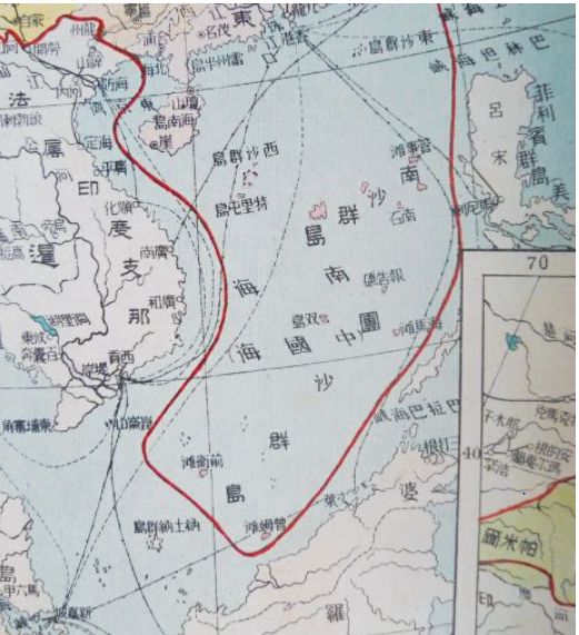
In 1936 Bai gave the
world his lasting legacy: a line drawn through the South China Sea. It was
included in a new book of maps, the New Atlas of China’s Construction
(Zhonghua jianshe xin tu), that Bai published for schools. He
included some of the new information about place names and frontiers agreed
upon by the government’s Maps Review Committee, published the year before. As
was typical of maps of this period, the atlas was, in many places, a work of
fiction. A bright red borderline stretched around the country, neatly dividing
China from its neighbors. The line was Mongolia, Tibet, and Manchuria, plus
several other areas that weren’t actually under the republican government's
control. However, the fictitiousness reached spectacular levels when it came to
the South China Sea.
It is clear that Bai
was quite unfamiliar with the South China Sea geography and undertook no survey
work of his own. Instead, he copied other maps and added dozens of errors of
his own making, errors that continue to cause problems to this day. Like the
Maps Review Committee, he was completely confused by the portrayal of shallow
water areas on British and foreign maps. Taking his cue from the names on the
committee’s 1934 list, he drew solid lines around these features and colored
them in, visually rendering them on his map as islands when in reality, they
were underwater. He conjured an entire island group into existence across the
sea center and labeled it the Nansha Qundao, the ‘South Sands
Archipelago.’ Further south, parallel with the Philippines coast, he dabbed a
few dots on the map and labeled them the Tuansha Qundao, the ‘Area of
Sand Archipelago.’ However, at its furthest extent, he drew three islands,
outlined in black and colored in pink: Haima Tan (Sea Horse Shoal), Zengmu Tan
(James Shoal), and Qianwei Tan (Vanguard Bank).
Thus, the underwater
‘shoals’ and ‘banks’ became above-water ‘sandbanks’ in Bai’s imagination and on
the map's physical rendering, he then added innovation of his own: the same
national border that he had drawn around Mongolia, Tibet, and the rest of ‘Chinese’
territory snaked around the South China Sea as far east as Sea Horse Shoal,
south as James Shoal and as far southwest as Vanguard Bank. Bai’s meaning was
clear: the bright red line marked his ‘scientific’ understanding of China’s
rightful claims. This was the very first time that such a line had been drawn
on a Chinese map. Bai’s view of China’s claims in the South China Sea was not
based upon the Review Committee’s view of the situation, nor that of the
Foreign Ministry. The result of the confusion generated by Admiral
Li Zhun’s interventions in the Spratly crisis of 1933, combined with
the nationalist imagination of a redundant geographer without formal academic
training. This was Bai Meichu’s contribution to Sun Yat-sen’s mission
of national reconstruction.
According to the
Taiwanese academic Hurng-Yu Chen, ‘Director-General of the Ministry of the
Interior Fu Chiao-chin . . . stated that the publications on
the sovereignty of the islands in the South China Sea by Chinese
institutions and schools before the Anti-Japanese War should serve as a
guidance regarding the territorial restoration issue.’ In other words, the
government would be guided by putative claims made in newspapers in the 1930s.
The meeting agreed that the entire Spratly archipelago should be claimed.
Still, given that only Itu Aba (Taiping Dao) had been physically
occupied, the claim should wait until other islands had actually been visited.
This never happened, but the claim was asserted nonetheless.
A key part of asserting
the claim was to make the names of the features in the sea sound
more Chinese. In October 1947, the RoC Ministry of the
Interior issued a new list of island names. New, grand-sounding titles replaced
most of the 1935 translations and transliterations. For example, the Chinese
name for Spratly Island was changed from
Si-ba-la-tuo to Nanwei (Noble South), and Scarborough Shoal was
changed from Si-ka-ba-luo (the transliteration) to Minzhu jiao (Democracy
Reef). Vanguard Bank’s Chinese name was changed from Qianwei tan
to Wan’an tan (Ten Thousand Peace Bank). The name
for Luconia Shoals was shortened from Lu-kang-ni-ya to just
Kang, which means ‘health.’ This process was repeated across the archipelagos,
largely concealing the foreign origins of most of the names. A few did survive,
however. In the Paracels, ‘Money Island’ kept its Chinese name
of Jinyin Dao and Antelope Reef remained Lingyang Jiao. To
this day, the two names celebrate a manager and a ship of the East India
Company, respectively.
At this point, the
ministry seems to have recognized its earlier problem with the translations of
‘shoal’ and ‘bank.’.’ In contrast, in the past, it had used the Chinese word
tan to stand in for both (with unintended geopolitical consequences), in 1947 it
coined a new word, ansha (Ànshā), literally ‘hidden sand’, as a replacement.
This neologism was appended to several submerged features, including James
Shoal, which was renamed Zengmu Ansha.
In December 1947, the
‘Bureau of Measurements’ of the Ministry of Defence printed an
official ‘Location Map of the South China Sea Islands’, almost identical to the
‘Sketch Map’ that Zheng Ziyue had drawn a year and a half before. It included
the ‘U-shaped line’ made up of eleven dashes encircling the area down to the
James Shoal. In February 1948, that map was published as part of the Atlas of
Administrative Areas of the Republic of China. The U-shaped line, with an
implicit claim to every feature within it, became the official position.
Therefore, it was not
until 1948 that the Chinese state formally extended its territorial claim in
the South China Sea to the Spratly Islands, as far south as James Shoal.
Clearly, something had changed in the years between July 1933, when the
Republic of China government was unaware that the Spratly Islands existed, and
April 1947, when it could ‘reaffirm’ that its territory's southernmost point
was James Shoal. What seems to have happened is that, in the chaos of the 1930s
and the Second World War, a new memory came to be formed in the minds of
officials about what had actually happened in the 1930s. It seems that
officials and geographers managed to confuse the real protest issued by
the RoC government against French activities in the Paracels in
1932 with a non-existent protest against French activities in
the Spratlys in 1933. Further confusion was caused by the
intervention of Admiral Li Zhun and his assertion that the islands
annexed by France in 1933 were indisputably Chinese.
The imagined claim
conjured up by the confusion between different island groups in that crisis
became the real territorial claim.
Pratas's islands
now a conservation zone, from where visitors can send postcards back home from
a mailbox guarded by a cheerful-looking plastic shark. Not far away is a new
science exhibition explaining the natural history of the coral reef and its rich
marine life.
Overlooking the
parade ground (which doubles as a rainwater trap) stands a golden statue of
Chiang Kai-shek in his sun hat, and behind him is a little museum in what looks
like a scaled-up child’s sandcastle.
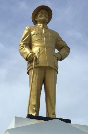
This museum holds, in
effect, the key to resolving the South China Sea disputes. Its assertion of
Chinese claims to the islets actually demonstrates the difference between
nationalist cartography and real administration. Bai Meichu may have
drawn a red line around various non-existent islands in 1936 and claimed them
as Chinese, but no Chinese official had ever visited those places. The maps and
documents on the museum walls tell the RoC expedition's story
to Itu Aba in December 1946 and a confrontation with some
Philippine adventurers in 1956. Still, in the absence of any other evidence,
the museum demonstrates that China never occupied or controlled all islands. In
the Paracels, it occupied one, or just a few, until 1974, when the
People’s Republic of China (PRC) forces invaded and expelled the Vietnamese
garrison. In the Spratlys, the RoC occupied just one or two. The
PRC took control of six reefs in 1988 and another in 1994.
In the meantime, the
other countries around the South China Sea, Vietnam, the Philippines, and
Malaysia, took control of other features. The real history of physical presence
in the archipelagos shows how partial any state’s claim actually is.
The current mess of
rival occupations is, with some exceptions, the only one that has ever existed.
Understanding this opens a route to resolving the South China Sea disputes. By
examining the historical evidence of occupations, the rival claimants should
understand that there are no grounds for them to claim sovereignty over
everything. They should recognize that other states have solid claims to
certain features and agree to compromise.
Conclusion: Taking the long view
Over the last two
decades, China has moved from the periphery to the very center of the world’s
international relations. Given that China’s economy is now more than five times as large as it was at the turn of the
millennium, that transition is hardly surprising. But many of China’s new
international relationships, initially hopeful, have now turned hostile. China
still has some down-at-the-heels allies, such as Pakistan and North Korea, but
it is increasingly isolated from the developed countries that alone can
facilitate its continued economic growth.
For China, that means
trouble. Its promises are no longer taken seriously, and its propaganda falls
on deaf ears. Many of its Belt and Road Initiative projects have ground to a halt. Virtually no one supports its nine-dash line in
the South China Sea, and Western countries have been lining up to offer immigration pathways to
professionals fleeing Hong Kong after Beijing’s takeover last year. Many
countries have banned China’s Huawei and ZTE from their telecommunications
networks. And India, Vietnam, Taiwan, South Korea, and Japan are all
modernizing their armed forces in response to potential Chinese threats.
Under these
circumstances, the best thing that U.S. President Joe Biden can do to stem the
rising tide of Chinese expansionism is … nothing. China’s red tide is already
rolling out all on its own. Biden can afford to pursue a policy of “masterly inactivity,” relying on China’s own aggressive
foreign policy to further isolate the country from the rest of the world.
Instead of increasing the pressure on China, now is the time for him to lighten
up a bit.
The worst thing Biden
could do is put so much pressure on China that its leaders lash out because
they feel they have nothing to lose. That was arguably what happened in 1941
when the United States successfully countered Japanese
expansionism with military aid to China, a trade embargo, and the freezing of
Japanese assets in the U.S. banking system. Japan wasn’t on the rise in 1941;
it was on the wane. Bogged down in China, checked by the Soviet Union in
a little-remembered conflict in Mongolia, and
increasingly squeezed by U.S. economic sanctions, Japan’s leaders recklessly
sought a kantai kessen (“decisive battle”) with a naval strike
at Pearl Harbor. They saw no other way to forestall a long, smothering defeat.
Of course, what
Japan’s leaders got instead was a decisive, blood-soaked defeat. But today, no
one except the hardest of hard-liners wants to see China defeated. That kind of
language makes no practical sense. Short of a world war, there is no way for anyone
outside China to dislodge Chinese Communist Party leadership from its
headquarters in central Beijing. A more sensible goal for the United States and
its allies would be to see China return to the slow liberalization trajectory
it was arguably following before President Xi Jinping took
power as the party’s leader at the end of 2012. And that’s a goal that China
must be convinced to choose for itself.
As long as China’s
leaders remain convinced that all of their problems stem from Washington’s ill
will, reform is unlikely. Today, they seem to completely buy into their own
narrative that the United States is a petulant former superpower too proud to
gracefully stand aside while China takes its rightful place at the top of the
world. But as China finds itself at odds with more and more countries, often
with no connection to U.S. pressure, its leaders may eventually get the
message. Whatever the future of their relationship with the United States, the
other countries of the world have their own reservations about Chinese
hegemony.
Australia’s fight
with China over the former’s efforts to restrict foreign influence, Japan’s standoff with China over the Senkaku Islands,
India’s actual battle with China in Ladakh, none of these were
prompted by U.S. arrogance. Nor was the South China Sea dispute, which pits China against no fewer than five of its
Southeast Asian neighbors. Beyond its immediate region, China is now also
arguing with European countries over human rights, with Latin American countries over illegal fishing, and with African countries
over-development debts. At some point, it must dawn on China’s leadership
that these problems have little or nothing to do with the United States, and
everything to do with their own provocative behavior.
The most effective
way the Biden administration can help drive home that message is to mind its
own business. Each of these countries has its own reasons to be unhappy with
China. They don’t need U.S. encouragement, and it would only muddy the waters
to offer support. For all Biden’s talk of working with allies and U.S. Secretary of State Antony
Blinken’s pledge to hold China “accountable for its abuses of
the international system,” they should resist the temptation to try to solve
other countries’ China problems. The truest love the United States can offer
the world on China right now is the tough love of encouraging other countries
to stand up for themselves.
Biden shouldn’t try to out former President Donald
Trump by showing he is even tougher on China. If Biden really wants to
differentiate his China policy, he should sit back and let history take its
course. While keeping sensible restrictions on Chinese access to U.S. advanced
technologies, he should consider pulling back in areas where the Trump
administration arguably overreached. A good first step might be to reverse
the steel and aluminum tariffs aimed at China that have
hurt friendly countries such as Japan and Taiwan. He could also lift
Trump’s visa limitations on members of the Chinese Communist
Party, which are almost entirely symbolic and nearly impossible to enforce.
Such measures would establish a more conciliatory tone in U.S.-Chinese
relations without relieving any of the pressure Beijing faces for reform.
As for the
above-mentioned Taiwan
Relations Act, which
made clear that the United States maintained special commitments to Taiwan.
When Sen. Rick Scott
asked Asia Pacific commander Philip Davidson whether it was
time for the U.S. to "state
clearly that we are not going to allow communist China to invade and subdue
Taiwan," Davidson did not shoot it down.
"I wake up every
day, you know, trying to assess the dynamic nature of the geostrategic
environment, and you know, frankly, we ought to be thinking about these things
every day," Davidson said.
"I would submit
that we have got more than 40 years of the strategic ambiguity, as you know,
has helped keep Taiwan and its current status, but you know these things should
be reconsidered routinely," he said, adding, "I would look forward to
the conversation."
Whereby as another
potential warning to China, Davidson said that while India may remain
committed to its nonaligned approach for the immediate future, he thinks
the country will deepen its engagement with the Quad. "I think that's a
key strategic opportunity for us, Australia, and Japan," he said.
In a CNN report also
quoted as saying: "I see them developing systems, capabilities and a
posture that
would indicate that they're interested in aggression."
Meanwhile, the US has
confirmed a high-level meeting with Chinese officials in Alaska next
week.
US Secretary of State
Antony Blinken will meet Yang Jiechi, China’s most senior foreign policy
official, and Foreign Minister Wang Yi Blinken and White House national
security adviser Jake Sullivan plans to discuss a range of issues with their
Chinese counterparts.
The meeting, slated
for Thursday will take place after US President Joe Biden takes part in a
summit with the leaders of Japan, India, and Australia, which together with the
US form an alliance known as the Quad. Blinken and Sullivan will use the
meeting with Yang and Wang to address a range of issues, including those where
the two sides have “deep disagreements.”
The trip comes as the
Biden administration has tried to highlight Washington’s alliances as an
essential part of its strategy to counter a rising China, a contrast to the
Trump administration’s more transactional approach to those relationships.
Even still, at the
House Armed Services hearing on Wednesday, a top Pentagon official overseeing
China policy insisted to lawmakers that the US was not asking any countries in
the region to “choose” between Washington and Beijing.
“We welcome and
encourage all nations across the Indo-Pacific to maintain peaceful, productive
relations with all of their neighbors, China included,” said David Helvey, the
acting assistant secretary of defense for Indo-Pacific security affairs.
Instead, Helvey said,
the fundamental choice for nations now is between two different international
orders: the existing one that is free and open, and
another, pushed by Beijing, that is authoritarian and closed. Whereby as we
have explained above it is doubtful the Chinese delegation will agree with the
latter charcterization.
1. Zhang Han, ‘China
Strengthens Map Printing Rules, Forbidding Publications Printed For Overseas
Clients From Being Circulated in the Country’, Global Times, 17 February 2019.
2. Laurie Chen,
‘Chinese City Shreds 29,000 Maps Showing Taiwan as a Country’, South China
Morning Post, 25 March
2019, https://www.scmp.com/news/china/society/article/3003121/about-29000-problematic-world-maps-showing-taiwan-country
3. After he entered
the Forbidden City, Ricci wrote: “The great courtyards in the Forbidden City
palace … could have held 30,000 people, and the emperor’s elephants, the 3,000
royal guards, and the huge walls all increased the sense of majesty and power,”
according to The Memory Palace of Matteo Ricci by US historian Jonathan Spence.
See also Zhu Yon, Yuanlu Qu Zhongguo (Long Way to China), which was published
in Chinese in 2019.
4. James D.
Richardson, ed., A Compilation of the Messages and Papers of the Presidents,
1789-1897 (Washington: Govt. print. off., 1896), v. 4, p. 211-214. House
Journal 27-3, p.122-124; House Document 27-3, no. 35, Fiche 420
5. Charles Maurice
Wiltse and Harold D. Moser, eds., The Papers of Daniel Webster: Diplomatic
Papers V. 1 (Hanover, N.H.: Published for Dartmouth College by the University
Press of New England, 1974), 900.; Richardson, ed., Messages and Papers, v. 4,
p. 211-214.
6. See Mark Bassin,
“Expansion and Colonialism on the Eastern Frontier: Views of Siberia and the
Far East in Pre-Petrine Russia,” Journal of Historical Geography 14, no. 1
(January 1988): 3–21, doi:10.1016/S0305-7488(88)80124-5; and for the nineteenth
century, Mark Bassin, Imperial Visions : Nationalist Imagination and
Geographical Expansion in the Russian Far East, 1840-1865 (Cambridge: Cambridge
University Press, 1999).
7. Narrative of the
Expedition of An American Squadron to the China Seas and Japan Under the
Command of Commodore M. C. Perry, United States Navy. Compiled at His Request
and under His Supervision, by Francis L. Hawks. Abridged and Edited by Sidney
Wallach, 1952, 62.
8. See George
Alexander Lensen, The Russian Push Toward Japan: Russo-Japanese Relations,
1697-1875, 1971.
9. Matthew Calbraith
Perry and Roger Pineau, The Japan Expedition. 1852-1854; the Personal Journal
of Commodore Matthew C. Perry (Washington, Smithsonian Institution Press,
1968), 138.
10. Narrative of the
Expedition of An American Squadron to the China Seas and Japan Under the
Command of Commodore M. C. Perry, United States Navy. Compiled at His Request
and under His Supervision, by Francis L. Hawks. Abridged and Edited by Sidney
Wallach, 1952, 303.
11. See George
Alexander Lensen, The Russian Push Toward Japan: Russo-Japanese Relations,
1697-1875,1971, 337.
12. Alan M.
Wachman, Why Taiwan? Geostrategic Rationales for China’s Territorial Integrity,
Stanford, CA: Stanford University Press, 2007, p. 69. 8. Ibid., pp.
50–60. 9. S.C.M. Paine, Imperial Rivals: China, Russia, and Their Disputed
Frontier, Armonk, NY: M.E. Sharpe, 1996, p. 352.
13. S.C.M.
Paine, Imperial Rivals: China, Russia, and Their Disputed Frontier, Armonk, NY:
M.E. Sharpe, 1996, p. 352.
14. Marie-Claire
Bergère (trans. Janet Lloyd), Sun Yat-sen, Stanford, CA: Stanford University
Press, 1998, pp. 92–6.
15. Shi-Chi Mike Lan,
‘The Ambivalence of National Imagination: Defining “The Taiwanese” in China,
1931–1941’, China Journal, 64 (2010), p. 179.
16. Hsiang-po Lee,
‘Rural-Mass Education Movement In China, 1923–1937, PhD thesis, University of
Ohio, 1970, pp. 60–61.
17. Robert Culp,
Articulating Citizenship: Civic Education and Student Politics in Southeastern
China, 1912–1940, Cambridge, Cambridge, MA: Harvard University Press, 2007, pp.
85–7.
18. Chen
Zhihong.“'Climate's Moral Economy': Geography, Race, and the Han in Early
Republican China.” In Critical Han Studies: The History, Representation, and
Identity of China's Majority, edited by Thomas S. Mullaney, James Leibold,
Stéphane Gros, and Eric Van den Bussche, pp. 80–81.
19. Peter Zarrow,
Educating China: Knowledge, Society and Textbooks in a Modernizing World,
1902–1937,2015, p. 242.
20. William A. Callahan,
‘The Cartography of National Humiliation and the Emergence of China’s Geobody’,
Public Culture, 21/1 (2009).
21. Alan M. Wachman,
Why Taiwan?: Geostrategic Rationales for China's Territorial Integrity (Studies
in Asian Security), 2007, p. 86.
22. Laura Hostetler,
Qing Colonial Enterprise: Ethnography and Cartography in Early Modern China,
Chicago: University of Chicago Press, 2001, pp. 117–20.
23. Diana Lary, ‘A
Zone of Nebulous Menace: The Guangxi/Indochina Border in the Republican
Period’, in Diana Lary (ed.), The Chinese State at the Borders, Vancouver:
University of British Columbia Press, 2007.
24. Wu Feng-ming, ‘On
the new Geographic Perspectives and Sentiment of High Moral Character of
Geographer Bai Meichu in Modern China’, Geographical Research (China), 30/11,
2011, pp. 2109–14.
25. Ibid., p. 2113.
26. Tsung-Han Tai and
Chi-Ting Tsai, ‘The Legal Status of the U-shaped Line Revisited from the
Perspective of Inter-temporal Law’, in Szu-shen Ho and Kuan-Hsiung Wang (eds),
A Bridge Over Troubled Waters: Prospects for Peace in the South and East China
Seas, Taipei: Prospect Foundation, 2014, pp. 177–208.
For updates click homepage here