By Eric Vandenbroeck and co-workers
Myanmar and the looming war for its borderlands Part
one
When I visited Burma, now called Myanmar, in 2015
(shortly after it was a lucky moment because the country had just started to
open up by lifting restringings to go into areas that
two years earlier would still be forbidden to go for someone like me, shortly
before my departure and upon arrival, I posted a sequence of case studies
illustrating what at the time was known about the history of Burman, particularly
also during the colonial period and what happened there during the second world
war, as can be seen here.
It was a lucky time because this was after allegedly
democratic Aung San Suu Kyi (daughter of General Aung San, who fought
with the Japanese against the allied forces during World War II) NLD party
won a sweeping victory in those elections, winning at least 255 seats in the
House of Representatives and 135 seats in the House of Nationalities. In
addition, Aung San Suu Kyi won re-election to the House of Representatives. And
led the leading generals at that time to open up the country, including areas
where foreigners previously were not allowed to go.
This was when Aung San Suu Kyi suddenly became
very much friends with some of the Generals, leading her to minister for the
President's Office, Foreign Affairs, Education, and Electric Power and Energy
in President Htin Kyaw's government. Whereby already that time it became clear
that this only meant a change in the capital Rangoon where people now soon were
able to bu Apple apple
I phones and other goodies with little changes in the countrysides
where I traveled hence on my first day of arrival I quoted what I thought was a
pertinent article stating "It
Is Not Enough for Elites Simply to Get Along" as stated here.
As explained recently,
we know how this ended. Which ten again brings us to the question I started
with when I arrived there in 2015, what next?
The background
For more than any other country in the world in the case
of Myanmar/Burma, as we also started to do in 2015 with a detailed ten-part historical case study, one
has to look at how the country was created, to begin with, or as we wrote in
2015, before British colonization, Burma or Myanmar, as it is known today,
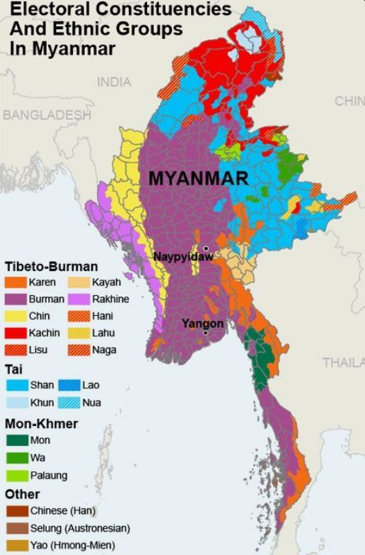
did not exist. Instead, the region consisted of independent kingdoms; Burman,
Mon, Shan, Rakhine, Manipuri, Thai, Lao, and Khmer kingdoms were located
throughout the area and were engaged in constant conflict.
On 12 February 1947, General Aung San expecting a
handover by the British signed the
Panglong agreement with representatives of the Shan, Chin, and Kachin
people, three of the largest of the many non-Burman ethnic groups that today
make up about two-fifths of Myanmar’s population. The agreement said that an
independent Kachin state was “desirable” and promised “full autonomy in
internal administration” to “Frontier Areas,” as today’s ethnic conditions were
then known. Aung San was
assassinated just over five months later. Under the 60 years of primarily
military rule that followed, the spirit of the Panglong agreement has never
been honored.
As Burma was then called, heading for independence in
the years after World War II, the British colonial power summoned
representatives of its many ethnic minorities for talks at Maymyo,
a picturesque hill station in the highlands east Mandalay called Pyin Oo Lwin.1 The hearings were called the Frontier Areas
Committee of Enquiry, and leaders of the non-Burmese peoples who lived in
territories far away from the country’s heartland on the plains of the
Irrawaddy River were invited to present what they expected from the proposed
Union of Burma. Did they want autonomy for their respective areas? A federation
of equal states? Or even their independent nations, separate from Burma? Under
British rule, central Burma had been ruled as a colony while the more than
forty Shan principalities, or the Federated Shan States, were protectorates.
Other areas were called ‘designated’ or ‘un-administered.’ It was a patchwork
of different jurisdictions, which now had to be brought under some kind of
unified, central administration.
Talks with major non-Burmese ethnic groups—the Shan,
Kachin, Chin, and Karenni (or Kayah)—went smoothly.
They came prepared and asked for autonomy within a proposed federal structure.
The Karen, who had been fiercely loyal to the British colonial power and even
fought with them against the Japanese- allied Burmese during World War II, did
not participate in the talks. Instead, they sent a letter stating that they
wished “to be in a distinct territory under the Governor's direct control,” or
a dominion that would be self-governing but remain under British sovereignty.2
The Wa sent four delegates.
Two of them represented Mong Lun and Hsawnglong, relatively developed Wa
principalities in the southern hills, while the other two came from the wilder
and more remote northern states of Mong Kong and Mong Mon. The hearings were headed by U Nu, who later
became independent Burma’s first prime minister. The southern Wa did not have any specific request. Naw Hkam U from Mong Lun stated only
that “we are not well educated in politics, but we are willing to abide by the
decision of the Federated Shan States Council,”3, while Sao Naw Hseng from Hsawnglong stated that
“Was are Was and Shans, are
Shans. We would not like to go into the Federated
Shan States.”4
If that were not puzzling enough, the talks with the
northern Wa revealed a wide gap between the Wa way of looking at life and the committee's perception of
it: Do you want any association with other people?
Hkun
Sai (for the Wa): We do not want to join anybody
because we have been very independent in the past.
What do you want the future to be in the Wa states?
Sao Maha (for the Wa): We
have not thought about that because we are very wild people. We never thought
of the administrative future. We think only about ourselves.
Don’t you want education, clothing, good food, good
houses, hospitals?
Sao Maha: We are very wild people and don’t appreciate
all these things.
Have you got any ideas as to how you would like the Wa states to be administered in the future?
Sao Maha: No.5
It shows that the Was did not think of themselves as
citizens of Burma, and that was not going to change after independence in 1948
or when the name of the country was altered Myanmar in 1989. The Wa did not have any concept of nations or states and were
never ruled by any outside power. The Frontier Areas Committee of Enquiry s
report stated that there are no post offices, but mails are accepted and
distributed if the administrative officers are addressed. Wa
literacy in any language was minimal, so they would hardly have been avid
letter-writers. The report went on to mention that “the only medical facilities
are those provided by the Frontier Constabulary outpost Medical Officers and by
itinerant Chinese practitioners (non-certificated) ... there is no organized
education service in the Wa states.”7
The early history of these idiosyncratic and isolated
people is shrouded in mystery. They are related to the Palaung, tea growers in
northern Shan State, and the Lawa in the hills of northern Thailand. The Mon
and the Khmer may speak related languages, but only the Wa
have converted to Buddhism. Even the Palaung have converted to Buddhism. Few of
Wa have remained faithful to their animistic beliefs
throughout history, and only in recent years have some become Buddhists or
Christians. We know for sure that the Wa and their
Tawa relatives have inhabited northeastern Shan State, southern Yunnan, and
northern Thailand for centuries. They may even be the original inhabitants of
those areas as the old Lanna kings in north Thailand and the Shan saohpa, or princes, in the eastern state of Kengtung paid a
token yearly tribute to the
When a Kengtung prince was crowned, two Wa always took part in the ceremony, and the Shan chief
would consider his coronation incomplete without them.9 The Wa
may have been despised as ‘savages,’ but the Shan had to recognize their unique
status as genuinely indigenous people. In Lanna, Thai historian Sarassawadee Ongsakul noted “that
the Lua [Lawa] was accepted as the original owners of the land can be seen in
the coronation procession, in which a Lua walks with a dog ahead of the king
into the city,”10 which was present-day Chiang Mai. The Wa
and the Lawa may not have lived in the fertile valleys where the Shan and Thai
settled, but they were undoubtedly the first to form communities in that part
of Southeast Asia.
Chronicles compiled by the Shan rulers, and research
done by British colonial administrators and Chinese officials, provide some
clues, but it is not certain that those accounts are accurate. Based on
interviews and oral history, they also contain widely differing interpretations
of the origin of the Wa. The intrepid British
colonial officer James George Scott, who traveled extensively in upper Burma at
the end of the nineteenth century, claims that the Wa
believe they originated from tadpoles and “spent their earlier years on the
lake at Nawnghkeo, an uninviting-looking oval lake at
the top of a mountain seven thousand feet high ... the lake is about half a
mile long and two hundred yards wide. It is said to be enormously deep, and so
cold that no fish can live in it.”11 When they “became frogs they moved to a
place called Nam Tao where, in the progress of time, they grew to be ogres,”12
and eventually morphed into human beings. According to Scott, they were head
hunters, but not cannibals, as rumored among the Shan who lived nearby and
feared these ferocious tribesmen.
A second version, put forth by V. C. Pitchford in a
1937 essay, also mentioned that lake. The name Nawnghkeo
is Shan for green lake, while the Wa call it Kaing
Kret. But Pitchford’s report has no reference to tadpoles, instead of
recounting that “from its primeval waters sprang the forebears of the Wa race and when they became men, they lived in the cavern
of Pakkatei and there they learned the mystery of
headhunting, whereby they waxed fruitful and multiplied exceedingly.”13 On the
other hand, Willy-Andre Prestre, a French researcher,
was told a story while smoking opium with some tribesmen that they were
descendants of frogs. He also recorded references to some kind of evolution
that eventually resulted in human beings. According to a fourth Chinese
version, “mankind came from a cave called Yang-ho.”14 That version of the
origin of the Wa makes no mention of tadpoles, frogs,
or head-hunting.
All those versions are part of local mythology and, as
Scott once remarked, Wa belief systems are “a jumble
of Buddhism, totemism, and simple fantasy”15 Buddhism entered their belief
systems through contacts with the Shan, called Dai in China, lowlanders living
mainly on the western side of the Wa Hills but also
in the east where they lived together with Han Chinese. The Shan, the British,
and the Chinese divided the Wa into ‘tame’ or ‘big’ Wa, those who had lived close to Shan or Chinese
civilization and adopted some of their respective customs, including Buddhism
and ‘the wild Wa,’ tribesmen who were still animists
with some elements of Buddhism, and also head hunters. It is head-hunting and
the presumed wildness of the Wa that has caught the
imagination of people in the outside world and instilled fear among the
neighbors of these fiercely independent tribesmen.
In his book Burma and Beyond, Scott noted that “the
fact is there has always been a fascination about the Wa.
Europeans first heard of them in the days of Vasco da Gama. At least, there
seems no reason to doubt the assertion about his experiences made in Camoens’ Lusiads that he came
across the Wa among the ‘thousand unknown natives.’
He calls them Gueos and said they were cannibals, and
that certainly was the belief even amongst their nearest neighbors, the Shans and the Burmese, until 1893, when a British party
went across the center of their country,”16 and, presumably, discovered that
they did not eat human flesh but were not averse to the habit of chopping off
people’s heads.
The origin of the Wa
head-hunting tradition is obscure and will probably never be fully fathomed.
One theory was produced by Alan Winnington, the Beijing correspondent for the
British communist paper The Daily Worker, in the 1950s. Armed with his
communist credentials, he was the only Westerner allowed to travel extensively
in remote parts of Yunnan. He later wrote a book called The Slaves of the Cool
Mountains, and although the title refers to the Norsu
tribe in northwestern Yunnan, it also includes a unique account of the Wa. Winnington retells a Wa
legend according to which decapitation began with a trick played on them by
Zhuge Liang, the famous Chinese warrior at the time of the Three Kingdoms, or
AD 220-280. To make them fight each other instead of their Chinese neighbors,
Zhuge has given the Wa boiled rice to plant, which,
naturally, did not grow. He then told the Wa that
their rice would succeed only if they sacrificed human beings and cut off their
heads. After the tribesmen heeded this advice, Zhuge gave them good rice seeds,
which increased.17 Chinese chronicles provide a similar account of the origin
of head-hunting, but there the evil trickster is a Shan, not a Chinese.18
On the Burmese side—and before independence in 1948—colonial
presence in the area was limited to occasional visits by adventurers like Scott
and annual flag marches up to what the British perceived as the border with
China. The Shan writer Sao Saimong Mangrai, a member of the Kengtung princely family, relates
in his book, The Shan States and the British Annexation, that “during the Wa Hills tour of a British officer in 1939, a Sikh doctor
had to be rushed out of the head-hunting area under an escort of a platoon of
troops when it was learned that the Wa had come and
offered 300 silver rupees to some of the camp followers for his head, which,
with its magnificent beard and mustache, they said would bring enduring
prosperity to their village.”19
Saimong Mangrais tale and Western
and Chinese accounts of head-hunting among the Wa
tend to describe it in the context of fertility rites and wishes for good
harvests. Magnus Fiskesjo, a Swedish anthropologist,
disputes this theory and argues that it had more to do with collecting trophies
in war with rival villages. No fertility god or deity figured in the
head-hunting rituals because, as Fiskesjo writes,
“the pantheon of spirits ... had no direct part in the arrangements of enemy
heads and skulls. Wa warfare practices of the past
must be understood within the social and regional context of conflict over land
and resources, not customs.’”20 Whatever the case, warfare between different Wa villages was prevalent. Given the tribal nature of Wa society, it would not have been necessary for someone
like Zhuge or anybody else to play tricks on them with boiled rice to pit one
community against another. As Winnington describes, “the Wa
people live on the jungle hilltops in fortified villages of bamboo, thatched
houses built on stilts.”21 A Wa village called Urnu he saw in China in the mid-1950s was no different from
those across the border in Burma at the same time and earlier:
Like all villages, Urnu is
surrounded by the high growth of dense Thornwood between 15 and 20 yards thick,
with dead and living thorns intertwined to form an impenetrable natural
barbed-wire barrier. At opposite ends of the village, two tunnels are cut
through the fence, closed on the inside by massive doors hacked out of large
trees—hinges, door, and bolt slots all cut from a single piece of
hardwood—giving the village the advantage over attackers in the tunnel.22
Skulls of decapitated enemies were put on display
outside the village to warn off intruders. Each town would have a drum house,
and drums would be heard during a festival or if people from a hostile village
were spotted in the vicinity. The Wa also displayed
heads of buffaloes, complete with impressive horns, as trophies suggesting
wealth and successful hunting trips. The horned buffalo has, in modern times,
become the symbol of the Wa nation.
According to Scott, “Most villages count their heads
by tens or twenties, but in some cases, they run into many more, according to
the age of the village, and whether, as sometimes seems to be the case, the
trophies or, as one might say, the guarantees, of one village, run into and
combine with another.”23 The Chinese, Scott noted, knew the Wa
best “since they have dealings with them in opium and salt.”24 Opium was a
significant cash crop in the hills and, as such, sold to Chinese merchants, and
their contacts spread far and wide in the region. G. F. Hudson, another British
colonial officer who wrote about the Wa during the
early colonial era, G. F. Hudson identifies the Panthay—
Chinese Muslims from Yunnan who had fled into Burma after rising against the
emperor, which lasted from 1855 to 1873 as the primary buyers of Wa opium. Historically, they have been excellent muleteers
and controlled much of the caravan trade in the region, not only the opium
business. In northern Thailand, other goods they transported as far south as
Chiang Mai included salt, tea, minerals, precious stones, and consumer goods.
But opium was a major commodity, and according to Hudson, the Panthay, the opium traders, were “financed by Singaporean
Chinese and they had 130 Mauser rifles with 1,500 mules, exporting opium by the
hundredweight into French, Siamese and British territory, each muleload
escorted by two riflemen.”25 For the little money the Wa
opium farmers got from selling their crop, they could buy salt, rice, and a few
other necessities from the Chinese merchants.
Silver mining was another source of income, and again
the buyers mainly were the Panthay and other Chinese
from Yunnan. Large-scale silver mining was carried out between 1650 and 1800,
and even gave name to what now is a town in the Wa
Hills: Vingngun, Shan for the silver town.’ It is not
unusual that towns and areas in the Wa Hills have
Shan names, and the partial conversion to Buddhism among some of them led to
the adoption of Shan political systems. While some Wa
chieftains did pay tribute to more powerful Shan saohpa,
Fiskesjo also notes that “these Wa
deflected Shan dominance by seizing on their geographical position to set
themselves up as Shan-style princes, on the model of those same threatening
Shan States, to be able to compete with them.”26 The outcome was the emergence
of what became known as the Wa states, sometimes even
spelled with a capital ‘s’.
The best organized of those Wa
states was Mong Lun in the southern hills. Tawang, or Ta Awng as he is sometimes called, proclaimed
himself saohpa in the early nineteenth century. He
died in 1822, and having no sons was succeeded by his nephew Hkun Hseng who had a Shan name,
became a Buddhist, and made the village of Pangkham
the capital of his state. After the British annexation of the Shan States in
the 1880s and 1890s, Mong Lun maintained cordial
relations with the various Shan saohpas and colonial
power. Several of the children in the ruling family were sent to schools in the
Shan States, and it was not unusual that they, apart from their native Wa, could speak Shan, Chinese, Burmese, and even English.27
Thus, it would not be fair to the Wa
to say that they were a backward tribe who lived in total isolation in their
mountains with little or no understanding of the outside world apart from some
interaction with their Shan and Chinese neighbors. The Wa
were more intelligent than that, and even the ‘wild’ ones had a notion of being
a people at the center of the universe. In his Ph.D. thesis, Fiskesjo noted:
The most salient feature of the general situation of
the Wa during the last few centuries is the
persistence of an autonomous Wa center, which was
politically and economically independent. This center was surrounded by a Wa periphery, in which people lived under the tenuous rule
of state societies yet farther beyond. The Wa people
residing in the central Wa lands take it for granted
that they live at the origin of the world they have remained.28
The Wa believe that other
sections of the human race have emerged later out of holes in the Wa mountains “from which all humanity come forth [and they]
have proceeded farther away—because the land was already occupied. This applies
to such non-Wa others as the Shan and the Lahu, the
Chinese and the Burmese, as well as any others still.”29 According to Fiskesjo, “the Wa also see
themselves as living at the top of the world, since it is where the highest and
most imposing mountains are.”30 The Lahu, who speak a Tibeto-Burman language,
are not ethnically or linguistically related to the Wa.
Still, the two hill peoples have always been close and are in some mythology
regarded as brothers.
The special status the Wa
enjoyed among the Shan, and the northern Thai is well documented and may have
enhanced that worldview. Their relations with the Chinese are also
well-established. Modern Chinese sources exaggerate that relationship to fit it
into the notion of a unified nation-state. If official Chinese sources are to
be believed, the Wa “came under the rule of the Han
Dynasty”31 in the second century AD: “After that, through the Tang, Song, Yuan,
Ming, and Qing dynasties, the Va (Wa) people have had
inseparable ties with other peoples in the hinterland.”32 That, of course, is
pure fantasy.
Chinese rule until the fourteenth century and the very
existence of a Wa people was virtually unknown to the
emperors in Beijing until the late eighteenth century.33
Colonial Britain, rather than China, was the first
outside power to claim the Wa Hills. After deposing Thibaw, the last king of Burma, in 1885 and sending him
into exile in India, the British conquered the Shan States. They wanted mainly
to avoid the emergence of an uncontrollable buffer area between them and the
French, who at about the same time were establishing their colonial rule in
Indochina, which included present-day Laos. Sir Charles Crosthwaite, British
Chief Commissioner of Burma in 1887-90, described the situation in this way:
Looking at the country's character lying between the
Salween and the Mekong, it was sure to be the refuge of all the discontent and
outlawry of Burma. Unless a government ruled it not only loyal and friendly to
us but thoroughly solid and efficient, this region would become a base for the
operations of every brigand leader ... or pretender ... where they might muster
their followers and hatch their plots to raid British territory when
opportunity offered. To those responsible for the peace of Burma, such a prospect
was not pleasant.34
Consequently, the Shan States were pacified’ over 1885
to 1890, and those areas achieved a status different from Burma proper. While Thibaw was deposed, the Shan princes were permitted to
retain their titles and rule their respective states like the Indian maharajas.
The Shan States had their administration, police forces, civil servants,
magistrates, and judges as protectorates and not colonies.35
Hudson wrote that “the annexation of Upper Burma in
1885, gave us a frontier with China, much of it so undefined that we had to
arrange for its delimitation by joint commissions of British and Chinese
officers. Neither side wanted the Wa States, a
singularly unattractive area, a liability, not an asset, and the Chinese, when
discussing the map, agreed to leave them on our side of the frontier.”36 The
British, Hudson said, were “left with the burden of policing them and
preventing their annual raids into the civilized territory.”37 Scott had
already concluded that “the Wa never stood against
us, even in their permanently fortified villages. Their shooting was puerile,
and our casualties were a mere handful. Still, their constant sniping and
ambushes were distracting ... [but] since they will never stand, it is
impossible to punish them save by burning their villages.”38
But Hudson also concluded—and that was as late as the
1930s— that “throughout history, the only administered area on either side of
the Burma-China frontier were the valleys and a few main routes. Even for the
Chinese, the hills were No Mans Land, and the Wa
massif was especially terra incognita. Nobody ever went there, and even the
approaches were dreaded, the Salween and Mekong valleys being
malaria-ridden—Chinese officers regarded the whole area as a penal station.”39
The presence of the Wa, and
prevailing myths about them, was another reason why Chinese administrators did
not venture into these remote mountains. Dorothy J. Solinger wrote in her study
of ethnic minorities in Yunnan:
The wild Kawa [i.e., Wa],
living between the Salween and the Mekong Rivers, were head-hunters. Their
fondness for warfare, and their superstitious belief that Chinese heads were
the most efficacious for their sacrifices, had historically kept the Han out of
their hills quite effectively ... these Kawa hated the Han and never came under
their influence. Only a few scattered Shan settlements dotted the otherwise
homogenous, isolated, and mountainous wild Kawa homeland on the Burma border.40
There is no historical evidence to suggest that the Wa saw Chinese heads as especially preferable or that heads
were used in religious rites. Still, just the notion that it could be true was
enough to keep all Chinese except some brave and locally connected silver and
opium traders out of the Wa Hills. Interaction with
the Shan was mainly in the valleys, and then when Wa
came down from their hills to buy or barter specific necessities.
Britain, however, had a fundamental strategic interest
in controlling the Chinese frontier. That meant establishing a semblance of
stability along the border and leaving the Wa to run
their affairs as long as they did not raid the lowlands. There was also nothing
there of any commercial interest. By the end of the nineteenth century, the
silver deposits had been depleted, and the opium grown in the Wa Hills was of poor quality, and most of it was consumed
locally.
The British policy towards the Wa
was to contain them rather than try to administer their hills. Peace in the
frontier areas was important because Britain’s interest in Burma was a backdoor
to China for trade and commerce. Other colonial powers recognized the strategic
importance of Burma, and some of them had been in the region even before the
British arrived on the scene. One of the first was the Vereenigde
Oost-Indische Compagnie (VOC), or the Dutch East
India Company. Having lost Formosa, or Taiwan, to rebellious Chinese forces
from the mainland in 1662 and then been excluded from Chinese ports, the Dutch
sought alternative trade routes to China. Burma seemed an obvious way from the
Bay of Bengal to the vast Chinese market, and that was why the Dutch maintained
a significant presence in Burma for nearly half a century. Their eye was on the
northern Irrawaddy River port of Bhamo at the beginning of an old trade route
called the ambassadors’ road,’ which ended in Yunnanfu,
today’s Kunming. Bhamo, in today’s Kachin State, was as far north as the
influence of the Burmese kings stretched in those days.
The VOC failed. “Time and again,” Dutch historian Wil
O. Dijk wrote, “the Company’s factors in Burma pleaded with the King to allow
the VOC a trading post on the Sino- Burmese border, but to no avail.
Eventually, this ban became a major factor contributing to the Dutch decision
to abandon Burma.”41 That was a significant setback for the Dutch because, as
Dijk writes, “there is perhaps no route by which overland traffic between
southwestern China and any point on the Bay of Bengal can so readily be carried.”42
Nevertheless, Dutch merchants stayed in Burma even
after the British conquest in the nineteenth century, and the colony attracted
a wide range of other merchants from all over the world. Rangoon, the capital
of British Burma since 1853, became one of the most cosmopolitan cities in
Asia, with significant foreign communities of Indians, Chinese, Armenians,
Jews, Persians, Europeans, and Eurasians. It was, of course, not because of
trade with China, but all kinds of commercial activities benefited from Burma’s
strategic location at the crossroads of South and Southeast Asia.
Some modern Chinese writers are eager to find
historical justifications for President Xi Jinping’s Belt and Road Initiative
(BRI). Pan Qi, a former vice-minister of communications, wrote for the
September 2, 1985 issue of the official Chinese weekly Beijing Review that
there was a road connecting western Yunnan with southeast and west Asia.43
There is no doubt that Zhang Qian wrote extensively about trade routes to and
from China, Central Asia, and beyond.44 But his attempts to forge a way from
Sichuan to India proved unsuccessful.
There may never have been a ‘southern Silk Road,’ but
the ‘ambassador’s road,’ sometimes called the ‘tribute road,’ was real,
although it could hardly be described as a highway. It got its name because
some Burmese kings and Shan princes paid tribute to the Chinese emperor, which
is interpreted as a kind of recognition of Chinese sovereignty over those
regions. This tribute payment should be seen as a bribe, not acceptance of the
authority of a higher power. Several Shan princes paid tribute to the Burmese kings
for precisely this reason.
British rule in Burma—and the Shan States—was meant to
change all that. On March 1, 1894, China and the United Kingdom signed a
convention meant to regulate, and perhaps even stimulate, cross-border trade.
There was even talk about building a railway from Burma to China. From 1894 to
1900, Major Davis, a British official, made remarkable surveying the northern
Shan States and Yunnan for possible railway routes. He found that the most
convenient way would be from Mandalay over the hills to Lashio and Kunlong on the Salween River. Along the Nam Ting River, a
Salween tributary, the terrain was relatively flat into Yunnan, where mountains
once again dominated the landscape.45 Davis argued that the railway should be
built on commercial—to facilitate cross-border trade—and political grounds: to
control the backdoor to China to secure British influence over Yunnan and other
restive provinces.
Unfortunately for Davis, his final surveys of the
projected railway across Yunnan were lost when his colleague, Captain W. A.
Watt-Jones was killed during the Boxer Rebellion in Beijing in 1900. If the
plan had materialized, the railway would have skirted the northernmost fringes
of the Wa Hills. The cost of such a railway would
also have been prohibitive. Davis estimated that a meter-gauge line would cost
20 million pounds and that the construction would take at least ten years.46 A
railway was built from Mandalay to Lashio, including the spectacular Gokteik Viaduct, built-in 1899 and opened in 1900.
Components for the 689-meter-long bridge were made by the Pennsylvania Steel
Company and shipped to Burma. The height of the bridge is 102 meters, the
highest in Burma and, at the time, the largest railway trestle in the world.
But after that, nothing more happened on the railway
front. Overall, trans-Burma trade with China proved disappointing, and Burma
Railways abandoned all construction plans beyond Lashio to the Chinese
frontier. John LeRoy Christian, a US army major, wrote in 1940 that even jade
from the mines around Hpakan
in Kachin State was no longer sent along the ancient routes through Guangxi
in southern China, but went by sea from Rangoon to Guangzhou and “Britain and
France forgot Yunnan and their rivalry for its trade.”47
It was not until 1937 that China and Britain awakened to
the importance of the Yunnan gateway. China was at war with Japan, Shanghai was
attacked, and the Japanese navy blockade Chinas maritime ports. Work then began
building an all-’weather highway from Burma to Yunnan to supply the Chinese
forces resisting the Japanese advance in the east. It was not only a matter of
cutting a road over the mountains of Yunnan. The Salween and the Mekong, two
great rivers, are also spanned by modern steel-cable suspension bridges.
Anywhere from 150,000 to 300,000 men using the most primitive engineering
equipment went to work, and as soon as it was opened in 1939, hundreds of
trucks sped off on the 1,145-kilometer run from Lashio to Kunming. Even after
its completion, no fewer than 30,000 men were kept constantly at work on
maintenance and improvement of the surface to make sure it could carry heavy
traffic.48 That was, of course, the famous and fabled Burma Road that wound its
way in numerous switchback curves over the mountains.
Then, the Japanese invaded Burma in January 1942. The
Burma Road was cut, and the allied forces—the United Kingdom and the United
States—had to look for an alternative route to send supplies to the Kuomintang
forces in China's interior. The American commander, General Joseph W. Stilwell,
who earned the nickname ‘Vinegar Joe’ for his short temper and abrasive manner,
came up with a bold solution: to cut an entirely new road from the small town
of Ledo in Assam in northeastern India across northernmost Burma into China,
where it would link up with the older Burma Road. He argued that it would be
possible because the Japanese never fully conquered the Naga and Kachin hills
in the north. Local Kachin guerrillas, supported by the United Kingdom and the
United States, were constantly harassing the Japanese. With some more Allied
support, they should maintain reasonable safety for the road construction
crews. Stilwell, who had served as a military adviser to the nationalist
Chinese leader Chiang Kai-shek, did not want to abandon him and his forces in
their fight against the Japanese. He had also brought Chinese soldiers to
India, where they were trained and equipped to assist the Allied forces. For
the British, it was also the beginning of the campaign to re-establish their
rule over Burma.
First went Stilwells
American-trained Chinese divisions, driving the Japanese before them. On either
side, Chinese and American patrols provided security for the road construction
teams in flanking movements. The trailblazers came to the heels of the Chinese
divisions, marking out the line with axes for the armored bulldozers that
followed. Last came the primary labor force, who blasted the road, paved it,
and constructed steel bridges across the innumerable streams and rivers along
the way.
While the Burma Road was built by Chinese labor,
Stilwell's road construction effort was one of the most mixed anywhere in the
world. Lieut.-Col. Frank Owen, a British officer in one of the teams, described
the laborers: “Chinese, Chins, Kachins, Indians, Nagas, Garos slashed, hauled
and piled, Negroes drove machines. Black, brown, yellow, and white men toiled
shoulder-deep in the streams, belt-deep in red mud. On one camp, 2,000 laborers
spoke 200 different dialects.”49
It was the British Empire that struck back against the
Japanese. Soon weapons carriers, tanks, and infantry columns flowed down the
ten-meter-wide double-tracked, metaled, trenched, banked, and bridged road
which Stilwell had initiated. The road, known as ‘the Stilwell Road’ or ‘the
Ledo Road,’ became a new highway stretching from Ledo to Kunming, totaling
1,726 kilometers.
Other dry-weather roads were built by Allied engineers
and local labor from India into the Chin Hills, from Manipur to the Chindwin
River, and the Arakan region across the border from East Bengal. The Japanese
were forced out of Rangoon in May 1945, and on August 15, their last units
surrendered to the Allied forces at the southeastern city of Moulmein. As LeRoy
Christian remarked in 1945, “Altogether, the isolation of Burma had been
destroyed by the current war.”50
The same was also held in the Wa
Hills. But their contacts with the outside world had already entered a new
stage when the first Western missionaries arrived there in the 1930s. The
trailblazer was Marcus Vincent-Young, an American Baptist whose father William
Young had come to Burma in 1892 and began spreading the gospel in Kengtung in
1901. After failing to convert any Buddhist Shan, he turned to missionary work
among the Lahu in Kengtung city's hills. The Lahu, like some other Southeast
Asian peoples such as the Karen further to the south in Burma, held a legend
predicting that a white man holding a big book would one day arrive to bring
salvation among people who could not read and write.
Adoniram and Ann Judson, American Baptist
missionaries, became aware of that tale when they arrived in southeastern Burma
in 1813, and to their initial astonishment, Karen came down in the thousands
from their hills to welcome the white foreigners.51
Similarly, thousands of Lahu flocked to Kengtung to
see and listen to Young, a white American who wore a white tropical suit and,
like the Judsons, carried his Bible wherever he went. He capitalized on the
fact that the Lahu had a similar belief, and his conversion rate was so high
that a delegation was sent to Kengtung to investigate. According to US
researcher Alfred McCoy:
Although the investigators concluded that Reverend
Young was pandering to pagan myths, Baptist congregations in the United States
were impressed by his statistical success. They had already started sending
significant contributions to ‘gather in the harvest.’ Bowing to financial
imperatives, the Burma Baptist Mission left the White God free to wander the
hills.52
Young put the Lahu language into Roman script and his
son Vincent, who went to work mainly among the ‘tame Wa
in the 1920s, did the same wherever he went. In 1933, Vincent Young and his Wa colleagues romanized the Wa language and published the first book in this new
script, a collection of hymns, identified on its title page as being written in
the ‘Kaishin dialect.’53 A complete translation of
the Bible into romanized Wa
was published in 1939. Vincent Young also founded a church and a missionary
school in Menglian in the Wa
area of southern Yunnan. The school educated hundreds of Wa
and Lahu students, many of whom became pastors of Christian congregations in Menglian itself and Gengma, Cangyuan, Shuangjiang, and
Lancang, all counties now on the Chinese side of the Sino-Burmese border.54
A constant problem for the British nominal overlords
was to determine the exact location of that border, which led to confrontations
with the Chinese when they, in the nineteenth century, began to claim the
mountains on the southern fringes of Yunnan. The British had made some attempts
to penetrate the area already before World War II. A Commission was
appointed to more firmly demarcate the border between Burma and China, and in
193536, attempts were made for the first time to survey the Wa Hills. The British also stationed two officers in the Wa Hills to “introduce light administration.”55
The road that was built into the northern Wa Hills in 1941 was part of those efforts. However, large
tracts of the Wa Hills remained inaccessible. It was
simply too dangerous for any outsider to venture into the areas where
head-hunting was still rife. Finally, in 1941, the British and the Chinese
agreed on where the border should be. But then the war broke out, and the
British were forced to leave Burma. Rangoon fell to the Japanese on March 8,
1942, and the rest of the colony was soon overrun as well. In the far north,
the Japanese did not establish control and in some parts of the Shan States.
The Burma Independence Army (BIA), led by Burmese
nationalist hero Aung San, had assisted the Japanese when they marched across
the border from Thailand and occupied Burma. But wary of local, ethnic
sentiments—many of the non-Burmese nationalities tended to be anti-Burmese as
well—the Japanese kept the BIA out of the Shan States when they tried to enter
the area in 1942.56 It was not until September 22, 1943, that Japan decided to
transfer “the Karenni states, Wa
states, and the whole of the Shan states except for Kengtung and Mong Pan state”57 to a Burmese puppet regime which the
Japanese had established in Rangoon on May 8 of that year. That regime
continued to govern Burma until the end of the war and was dissolved only when
the British returned. It was the Imperial Japanese Army that remained the most
powerful institution in Burma throughout the occupation.
Kengtung and Mong Pan were
given to Thailand, a Japanese ally, whose support was necessary to secure the
borders of the occupied territories. As the British had evacuated Burma and the
Shan States in 1942, they sought help from Chiang Kai-shek, who sent the 93rd
Division into Kengtung while the 249th and 55th Divisions moved into the Karenni States and the southern Shan States. According to
Shan historian Sai Aung Tun, “the Chinese soldiers were generally not well
trained or well-equipped like the Japanese. The Chinese were badly defeated by
superior numbers and mechanized equipment, including airplanes, against which
they had no defense.”58
On May 3, 1942, twenty-seven Thai airplanes flew over Kengtung,
where the Chinese troops were stationed, and bombed the market. The bombardment
inflicted heavy casualties on the Chinese, who withdrew close to the Chinese
border to the north. A few weeks later, Thai troops led by Field Marshal Pin Choonhavan and his son, Chatichai
Choonhavan, marched into Kengtung, and the Thai flag
flew over the town.59 Kengtung, with 31,000 square kilometers, the biggest of
the Shan States, and the much smaller Mong Pan State
across Thailand’s northwestern border, were placed under Thai administration,
which the Japanese recognized the following year. Thailand was also given areas
in northern Malaya and western Laos as part of the Japanese scheme to establish
what they called ‘The Greater East Asia Co-prosperity Sphere.’60
Fierce fighting raged for months in the north. As the
British and their mostly Indian troops retreated towards India or China, they
were bombed by the Japanese. According to Sai Aung
Tun, “corpse after corpse lay scattered in towns,
especially Lashio, Hsenwi,”61 and along the Burma Road, “which came to be known
as the Road of Death.”62 The Wa Hills, however, was
never the scene of any severe warfare. The Japanese were probably as afraid as
anybody else to enter the area. The only recorded exception occurred in the
northern Wa Hills shortly after the Japanese
invasion. A small contingent of Japanese troops, escorted by a Shan from west
of the Salween River, attacked a Wa settlement near Mong Mau and killed twenty-one villagers who, presumably,
were armed as well.63
The situation was different in Kokang immediately to
the north of the Wa Hills. There, the local Chinese
population resisted the Japanese when they tried to enter the area at Kunlong on the Salween River. The local ruler of Kokang,
Yang Wen-pin, allied himself with the nationalist Chinese, and in 1943 he and
his then twenty-three-year-old son Yang Kyein-sein,
or Jimmy Yang, were invited to visit Chiang Kai-shek at his wartime capital of
Chongqing.64 Jimmy Yang later became a prominent businessman and politician in
Burma, and in the 1960s and 1970s, joined a rebel army opposed to military
rule.
Kengtung and Mong Pan were
returned to the Shan States when the British returned in 1945, not to
reestablish colonial rule but to prepare for Burma’s independence. The Frontier
Areas Committee of Enquiry was an important part. The Karen never joined the
talks and did not, in 1947, go to the small market town of Panglong, north of
the Shan States capital Taunggyi, to sign an agreement which paved the way for
Burma to become a democratic federal republic with local autonomy for the
frontier areas. The day representatives of the Shan, the Kachin, and the Chin
signed the Panglong Agreement with Aung San. February 12 is still celebrated as
Union Day, a national holiday.65
The Shan saohpa also asked
for and were granted the right to secede from the proposed Union of Burma after
ten years of independence, that is, in 1958, should they be dissatisfied with
the new federation. This right was ensured under the first Burmese
Constitution, Chapter X, but applied only to the Shan and Karenni
states. The 1947 Constitution stipulated that other states could also be
formed, the first would be for the Kachin and the Karen, but those states would
not have the right to secede from the Union.66
Talks with the Wa did not
produce any tangible results or recommendations. Based on the Panglong
Agreement and the 1947 Constitution, Burma became an independent federal
republic on January 4, 1948, but it had no absolute jurisdiction of the Wa Hills. During the last years of colonial rule, the
British had attempted to establish some indirect control by appointing Harold
Young, William Young's son and Vincent’s brother, as assistant superintendent
of Mong Lun and adjacent areas. Although he was
American, he had been given the rank of captain in the British Army. He was
commanded by two mostly Shan soldiers who fought against the Japanese when they
occupied most of Burma. Harold Young’s knowledge of the area and local
languages were invaluable assets to the British. He also saw action with the
Americans and the British against the Japanese in the Kachin Hills in the
country's far north. He was recruited by the US Office of Strategic Services, a
forerunner to the Central Intelligence Agency (CIA).67
After the war, Harold Young tried and convicted
several local warlords suspected of having collaborated with the Japanese. Khun
Ja, the uncle of Khun Sa, became a prominent drug trafficker in the 1960s and
ran his private army in the Golden Triangle. Thailand, Burma, and Laos meet in
this notorious drug-producing area until he eventually surrendered to the
Burmese government in January 1996. A gunshot executed Khun Ja to his head on
the banks of the Irrawaddy River.68
Whatever control the British, and after 1948 the
government of independent Burma may have had in some outlying areas, was
abandoned when in the early 1950s renegade nationalist Chinese Kuomintang force
overran large tracts of the eastern Shan States. Beaten and defeated by Mao
Zedong's communists in the Chinese civil war, they had been unable to join the
main force that retreated, along with Chiang Kai-shek, to Taiwan. The only
alternative to surrender was to regroup in the mountains across Chinas southwestern
border.
However, Kuomintang soldiers first entered the
northern Wa Hills and then marched through Mong Lun, where the local ruler protected his people and
their area. The nationalist Chinese pushed on to the mountains north of
Kengtung, the home of Akha, Palaung, and other hill peoples. That area was
easier to control than the wild Wa Hills. The
Kuomintang also established Kokang, a district north of the Wa
Hills populated by ethnic Chinese of Yunnanese stock.
Even if the Kuomintang presence in the Wa Hills was
relatively limited, the Wa, who had been largely
spared the devastation of World War II, found themselves caught up in the
intricacies of world politics.
The Kuomintang built an airbase at Mong
Hsat near the Thai border. Soon, supply flights began
to arrive from Bangkok and Taiwan, where the Republic of China, defeated by the
communists on the mainland, lived on under Chiang Kai-shek and his main
Kuomintang force. The effort was supported by the United States and its Central
Intelligence Agency (CIA), and the plan was to reconquer the mainland from
those bases in the northeastern mountains of the Shan States. It was, in a
sense, the CIA’s first secret war, and General Li Mi, the Kuomintang officer in
charge of the operation, was proclaimed commander of the ‘Yunnan Province
Anti-Communist National Salvation Army’69.
The United States and its allies were fighting under
the United Nations banner against North Korean and Chinese forces on the Korean
peninsula. Claire Chennault, a hardline former US general and World War II
hero who had served as an adviser to Chiang Kai-shek, later admitted publicly
that a plan existed to wage a broader war against China, using Burma as a
springboard:
It is reported—and I have reason to believe it is
true—that the Nationalist [KMT] Government offered three entire divisions ...
of troops to fight in Korea. Still, the great opportunity was not putting the
Nationalists in Korea. It was a double envelopment operation. With the United
Nations forces in Korea and the Nationalist Chinese in southern areas ... the
Communists would be caught in a giant pincer ... this was a great
opportunity—not to put the Nationalist Chinese in Korea, but to let them fight
in the south.70
Between 1950 and 1952, the Kuomintang army in Burma’s
Shan States tried to invade Yunnan but was repeatedly driven back across the
border. The Burmese Army then entered the Shan States to rid the country of its
uninvited guests, which led to an unprecedented militarization of the Shan
States. But the areas east of the Salween River were too remote to be affected
by the buildup. There, the Kuomintang reigned supreme through alliances with
local warlords, most of them from Kokang and the eastern Shan States, but some
were also Wa.
The Burmese government raised the issue in the United
Nations. On April 23, 1953, the General Assembly adopted a resolution stating
that “these foreign forces [i.e., the Kuomintang] must be disarmed and either
agree to internment or leave the Union of Burma forthwith.”71 At first, the UN
resolution seemed to have had some impact on the situation. On October 29, a
joint US-Thai-Taiwan communique was issued in Bangkok, stating that 2,000
nationalist soldiers, including their families, would be withdrawn. Taiwan also
pledged it would no longer supply the troops in Burma with weapons, and those
who remained there would be disowned.72
The evacuation began in February 1954 and lasted for a
month. Kuomintang soldiers were brought by truck from the border to Chiang Mai
in northern Thailand. They were paraded through the streets in bright uniforms
and newly issued tennis shoes before boarding US aircraft destined for Taiwan.
Other units left via Chiang Rai north of Chiang Mai and Lampang to the south.
The evacuation no doubt weakened the Kuomintang, but
several thousand of its troops remained in the hills of the eastern and
southern Shan States. It was also becoming increasingly clear that not all the
troops sent to Taiwan were genuine Kuomintang soldiers. The US researcher
Alfred McCoy noted:
“Many of the troops carried rusting museum pieces as
their arms. Now allowed into the staging area, the Burmese observers frequently
protested that many supposed Chinese looked
more like Lahus or Shans. Although other observers ridiculed those
accusations, the Burmese were correct. Among them, there were a large number of
boys, Shans, and Lahu. Even by 1971, there were an
estimated 300 Lahu tribesmen still living in Taiwan who had been evacuated
during this period.73
The Yunnan Province Anti-Communist National Salvation
Army was officially disbanded, but thousands of nationalist Chinese soldiers
remained in the Shan States and settlements with Thailand. The hill peoples
living in the areas where they operated were the most tragic victims of the
war, which continued for years after the so-called repatriation in 1954. Elaine
Lewis, an American Baptist missionary working first in Kengtung and then in
northern Thailand, wrote in 1957 that “at the time the Chinese Communists
occupied Yunnan Province to the border of Kengtung State in 1950, a great flood
of hill peoples came down to Kengtung State.”74 According to Lewis, the
Kuomintang invasion forced many of them to flee again:
For many years there have been large numbers of
Chinese Nationalist troops in the area demanding food and money from the
people. The areas in which these troops operate are getting poorer and poorer,
and some villagers are finding it necessary to flee ... many hill people from
the region have found their way into the hills of northern Thailand so that no
one may discover substantial numbers of Lahus, Akhas,
Meau [Hmongj, Was, and other hill tribes originally
from Kengtung in the hills of northern Thailand.75
Even if some villagers fled across the border when
soldiers from the Chinese Peoples Liberation Army
(PLA) entered southern Yunnan in the early 1950s, they were at first quite
lenient in their treatment of the hill peoples. Hardly any Chinese had been
there before, which was the reason some fled. The PLA was seen as a foreign
force, so people were afraid and did not expect. But the main reason the PLA
had entered the area was to prevent the Kuomintang from crossing the border
with Burma, and for that, they needed the support of the local people. In his
account of his travels in the Chinese Wa Hills,
Winnington met a Wa leader called Jabuei,
who told him that the PLA first came into the area in 1950 and called him and
other village headmen to a meeting:
They said they were against the Kuomintang, so we
listened to them, although they were Hans [Chinese]; they told us that there
would be no more oppression of the minority peoples once the Kuomintang was
driven out the Hans. We should be masters of our own lives, and they would
co-operate with the headmen and bring a better life to all the Wa people. Instead of stealing from our people, they would
get gifts and new doctrines that would help the Wa to
grow rich like the Hans.76
To spread literacy among the Wa
in China, the new communist authorities introduced an unknown writing system
for their language in 1957. Like the Wa script
invented by Vincent Young and his Wa workers, it was
also based on the roman alphabet but was designed to be closer to the then-new
pinyin romanization of Chinese characters.77
Chinas own way of romanizing
the Wa language was, as Fiskesjo
points out, part of a broader scheme “to support the political and military
consolidation of Chinese rule over the area, and the introduction of social and
economic reforms.”78 Primarily, it included the establishment of Chinese rule
where there had been none before, including crushing
what the Chinese communists labeled canfei, ‘bandit
remnants,’ or the remnants of the Kuomintang.79
After a few years of leniency, the Chinese authorities
introduced an entirely new oppressive system as soon as the Kuomintang threat
had been eliminated. Weapons in possession of Wa
tribe members, who were used to being armed because they depended on hunting,
were confiscated, and according to Fiskesjo all
paraphernalia associated with head-hunting was thoroughly destroyed, along with
the social institutions that sustained independent Wa
society:
Drum-houses were torn down, along with any njouh head-poles [a head-hunter’s head-container] planted
near them; the log drums were thrown out or burned. The roadside a nog [head-container posts planted along with the approach
to a village] were destroyed or abandoned. The significant rituals of the past
were abandoned. Chief ritualists and other leaders were demoted, marginalized,
or even persecuted.
Wa
elders Fiskesjo spoke to regarded 1958 as the
critical watershed “since in that year the Chinese shifted policy from
reconciliation to enforcement.”81 Even the Wa had to
become Chinese communists and were herded into people’s communes.
In the Shan States of Burma, discontent was simmering.
As Shan’s constitutional right to secede from the Union was coming into force
in 1958, meetings were held in many towns, and demands were raised for
independence. The Burmese Army’s war against the Kuomintang meant that the Shan
had become squeezed between two forces, both of which were perceived as foreign
and oppressive. The government tried to suppress the growing nationalist
movement by using the army and its dreaded intelligence service, which, in effect,
functioned as a secret police force. But the outcome was counterproductive.
Groups of young people moved into the jungle, where they organized armed
guerrilla units. One such group was Noom Suk Harn, or
‘The Young and Brave Warriors,’ led by Saw Yan Da. His other name was Sao Noi,
and he was a Shan from Yunnan. He was joined by some university students who
had fled the towns when the Burmese Army began its campaign to suppress the
Shan nationalist movement.
In 1959, a well-known Union Military Police officer
named Bo Mong joined the rebellion. He was an ethnic Wa, and with a band of Wa
warriors and Shan students, he launched a surprise attack on the garrison town
of Tang-yan. They managed to capture Tang-yan while another group tried, unsuccessfully, to attack
Lashio in the north. It was not a well-planned and synchronized military
campaign, and the Burmese Army eventually managed to recapture Tang-yan. But the authorities in Rangoon were taken aback by the
sudden outburst of violence in the Shan States. Tang-yan's
battle marked the beginning of a long war between the Union Government and
various Shan rebel armies.
In 1959, the Shan saohpa-whose
attitude to the rebellion had been ambivalent—some supported it while others
wanted to remain within the Union—formally renounced all their powers at a
grand ceremony held at the state capital of Taunggyi and attended by all the saohpa as well as the commander of the Burmese Army,
General Ne Win, who was then heading a caretaker government. The duties of the saohpa were taken over by the elected Shan State
government. The Shan States became Shan State, and it was hoped this would
satisfy the aspirations of the nationalists. It did not. In April i960, a new,
better-organized rebel force, the Shan State Independence Army, was formed by
Shan students who, dissatisfied with the authoritarian rule of Sao Noi, had
broken away from his Noom Suk Harn.82
In the early 1960s, the Kachin in the far north were
also getting prepared to rebel. General Ne Win had allowed elections in 1960,
and U Nu was returned to power. But one of his election promises had been to
make Buddhism the state religion of Burma, a move seen by the predominantly
Christian Kachin as an open provocation.
In i960, the Burmese and Chinese governments had
finally managed to demarcate their shared border. As part of the deal, three
Kachin villages and the Panhung-Panglao area in the Wa Hills had been handed over to the Chinese in exchange
for Burmese sovereignty over an area northwest of the town of Namkham known as the Namwan
Assigned Tract. The village tracts in Kachin State encompassed 152 square
kilometers, and the Wa territory ceded to China was
189 square kilometers in area.83 The deal was not unfair by international
standards, but rumors soon spread across Kachin State to the effect that vast
tracts of Kachin territory had been handed over to China.
On February 5, 1961, in response to making Buddhism
the state religion and the border issue, a group of Kachin led by World War II
veteran Zau Seng formed the Kachin Independence Army (KIA). It soon took over
large tracts of land in Kachin State and the Kachin-inhabited areas of northern
Shan State.
On the Thai border, Karen, Karenni,
and Mon rebel armies had been active for years. Burma was in turmoil, and on
March 2, 1962, General Ne Win stepped in, overthrew the elected government of U
Nu, and introduced not a caretaker government, as in the late 1950s, but a
straightforward military dictatorship. While it was meant to contain and
eventually crush the ethnic insurgencies, the outcome was just the opposite.
Those rebellions flared anew as opposition grew against the new military
government, which had abolished the limited autonomy the ethnic areas had
enjoyed under the 1947 Constitution and replaced it with the strict centralized
rule. The 1962 coup also led to the rebirth of the insurgent Communist Party of
Burma, which from powerful beginnings in the early 1950s had dwindled into a
rag-tag army holding out in isolated pockets in central Burma.
1. Minutes from the
hearings were published as Frontier Areas Committee of Enquiry 1947: Part II
(1947). Rangoon: Government Printing. See also Tualchin
Neihsial (ed.) (1998), Burma: Frontier Areas
Committee of Enquiry Report. New Delhi: Inter- India Publications (first
printed in the United Kingdom in 1947 by His Majesty's Stationery Office.) I
have used ‘Burma as the name for the country. In 1989, the then ruling military
junta decided to call it ‘Myanmar5 even in English texts (it has always been
Myanmar or Bama in the Burmese language, the former being a more formal name
and the latter used in colloquial speech). At the same time, the names of many
local places were changed as well, among them Maymyo,
which became Pyin Oo Lwin.
2. Frontier Areas
Committee of Enquiry 1947 p. 175*
3. Ibid. p. 35.
4. Ibid. p. 36.
5. Ibid. pp. 37, 39.
6. Ibid. p. 190.
7. Ibid.
8. For an account of
the relationship between the Lawa (or Lua) and the Shan and the northern Thai,
see Sarassawadee Ongsakul,
History of Larina (2005). Chiang Mai: Silkworm Books, pp. 30-32.
9. G. R Hudson, The Wa People of the Burma-China Border (1957), St. Anthony's
Papers, 11, Far Eastern Affairs. London: Chatto & Windus, p. 128.
10. Sarassawadee
(2005), p. 32.
11. Sir J. George Scott (1932), Burma and Beyond.
London: Grayson & Grayson, p. 292.
12. Ibid. p. 292.
13. Quoted in Taryo Obayashi (1966), ‘Authropogonic
Myths of the Wa in Northern Indo-China. 5 Hitotsubashi Journal of Social Studies, vol. 3, no. 1, p.
45. Available at
https://hermes-ir.libhit-u.ac.jp/rs/bitstream/10086/8490/24/HJs0c0030100430.pdf
14. Ibid. p. 46.
15. Quoted in ibid. p. 59.
16. Scott (1932), p. 292.
17. Alan Winnington (1959),
The Slaves of the Cool Mountains: The Ancient Social Conditions and Changes Now
in Progress on the Remote South-Western Borders of China. London: Lawrence
& Wishart, p. 131. Zhuge Liang is spelled Chu Ko-liang in Winningtons book.
18. Ma Jianxiong
(1913), ‘Clustered Communities and Transportation Routes: The Wa Lands Neighboring the Lahu and the Dai on the Frontier.5
Journal of Burma Studies, vol 17, no. 1, p. 107. Available at
http://www.ha.cuhk.edu.hk/Papers%202013/Ma%20
Jianxiong_Clustered%2oCommunities%2oand.pdf
19. Sao Saimong Mangrai (1965), The Shan
States and the British Annexation. Ithaca: Cornell University Southeast Asia
Program, p. 271.
20. Magnus Fiskesjo (2014), ‘Wa Grotesque:
Headhunting Theme Parks and the Chinese Nostalgia for Primitive
Contemporaries,5 Ethnos: Journal of Anthropology, vol. 80 (August), p. 3.
Available at https://www.tandf0nline.c0m/d0i/abs/10.1080/00141844. 2014.939100
21. Winnington
(1959), p. 131.
22. Ibid. p. 133.
23. Scott (1932), pp. 296-97.
24. Ibid. p. 299.
25. Hudson (1957), p.
129.
26. Magnus Fiskesjo (2010a), ‘Mining, History, and the Anti-state Wa: The Politics of Autonomy between Burma and China,5
Journal of Global History, vol. 5, no. 2, p. 248.
27. Saimong (1965), pp.
263-64, and Sao Sanda Simms (2017), ‘Great Lords of the Sky: Burma’s Shan
Aristocracy.5 Self-published under Asian Highlands Perspectives, no. 48, pp.
415-16.
28. Magnus Fiskesjo
(2000), The Fate of Sacrifice and the Making of Wa
History. Unpublished Ph.D. thesis, University of Chicago, p. 49.
29. Ibid.
30. Ibid. p. 50.
31. Ma Yin (ed.)
(1989), Chinas Minority Nationalities. Beijing: Foreign Languages Press, p.
278.
32. Ibid. pp. 278-79.
33. Magnus Fiskesjo (2012), ‘Kinesiska perspektiv pa Wa-folkets
historia5 (in Swedish), Kina Rapport (March 13), p. 80.
34. Sir Charles
Crosthwaite (1912). The Pacification of Burma. London: Edward Arnold, p. 128.
Available online at https://archive.org/stream/pacificationofbuoocrosrich/
pacificationofbuoocrosrich_djvu.txt
35. For a succinct
history of Shan-Burmese relations during the British era, see Chao Tzang Yawnghwe [1987] (2010), The
Shan of Burma: Memoirs of a Shan Exile. Second, revised edition, Singapore:
Institute of Southeast Asian Studies, pp. 47-90.
36. Hudson (1957)*
PP* 129-30.
37. bid. p. 130.
38. G. E. Harvey (1933), 1932 Wa
Precis: A Precis Made in the Burma Secretariat of all Traceable Records
Relating to the Wa States. Rangoon: Office of
Superintendent, Government Printing and Stationery, Burma, p. 40.
39. Hudson (1957), p.
129.
40. Dorothy J. Solinger (1977), ‘Minority
Nationalities in Chinas Yunnan Province: Assimilation, Power, and Policy in a
Socialist State’ World Politics, vol. 30, no. 1 (October), p. 12. Available at
https://www.researchgate.net/publication/259380631_
Minority_Nationalities_in_Chinars_Yunnan_Province_Assimilation_Power_and_
Policy_in_a_Socialist_State
41. Wil O. Dijk (2006), Seventeenth-century Burma
and the Dutch East India Company; 1634-1680. Singapore: Singapore University
Press, p. 191.
42. Ibid. p. 175.
43. Ibid.
44. See Tian Jinchen,
‘One Belt and One Road: Connecting China and the World5 (2017), paper prepared
for McKinsey and Company (April 19). Available at https://
www.mckinsey.com/industries/capital-projects-and-infrastructure/our-insights/
one-belt-and-one-road-connecting-china-and-the-world
(accessed March 20,2018) Tian mentions how Zhang Qian ‘helped establish the
Silk Road,5 but there is nothing about his attempts to reach India.
45. For the plans to
build a railway to China, see John L. Christian (1940), ‘Trans-Burma Trade
Routes to China,5 Pacific Affairs, vol. 13, no. 2, pp. 185-87. Available at
https:// www.jstor.org/stable/275i052?seq=i#page_scan__tab_contents
46. Ibid. p. 186.
47. Ibid. p. 187.
48. Ibid. p. 188. See
also H. G. Deignan (1934), Burma: Gateway to China. Washington: The Smithsonian
Institution, p. 15.
49. Frank Owen
(1984), The Campaign in Burma. Dehra Dun:
Natraj Publishers, p. 76.
50. John LeRoy Christian (1945), Burma and the
Japanese Invader. Bombay: Thacker & Company, p. 360.
51. See San C. Po (1928), Burma and the Karens.
London: Elliot Stock, p. 23. See also Bertil Lintner [1994] (2011), Burma in
Revolt: Opium and Insurgency Since 1948. Fourth edition, Chiang Mai: Silkworm
Books, pp. 49-51.
52. Alfred W. McCoy
(1972). The Politics of Heroin in Southeast Asia. New York: Harper Torchbooks, p. 304.
53. ‘The Young
Family’s Work with the Wa People5 Available at
http://www.humancomp. org/wadict/young_family.html
54. Ibid.
55. Hudson (1957), p.
133.
56. Samara Yawnghwe (2013), Maintaining the Union of Burma 1946-1962:
The Role of the Ethnic Nationalities in a Shan Perspective. Bangkok: Institute
of Southeast Asian Studies, Chulalongkorn University, p. 120.
57. Sai Aung Tun
(2009), History of the Shan State: From Its Origins to 1962. Chiang Mai:
Silkworm Books, p. 203.
58. Ibid. p. 195.
59. Chatichai Choonhavan later became
a Thai politician and served as the country's prime minister from 1988 to 1991.
60. Sai Aung Tun (2009), pp. 201-2.
61. Ibid. p. 200.
62. Ibid.
63. This according
to Singapore scholar Andrew Ong.
64. Yang Li, The
House of Yang: Guardians of an Unknown Frontier, Sydney: Bookpress,
1997, p. 51.
65. For the full text
of the Panglong Agreement, see http://www.ibiblio.org/obl/docs/
panglong_agreement.htm and for download, http;//www.myanmar-law-library.
org/law-library/laws-and-regulations/constitutions/the-panglong-agreement-1947.html
66. The full text of
the 1947 Constitution is available at http://www.myanmar-law-
library.org/law-library/laws-and-regulations/constitutions/1947-constitution.html
(accessed March 20, 2019). Chapter IXU78 states that “The Provisions of Chapter
X of this Constitution shall not apply to the Kachin State.” Chapter IX:i8i
(10) says that “The Provisions of Chapter X of this Constitution shall not
apply to the Karen State.”
67. David Lawitts (2015), £The Grand Old Man of Chiang Mai: The Life
of Harold Young.1 Chiang Mai City Life (April 1). Available at
https://www.chiangmaicitylife.
com/citylife-articles/the-grand-old-man-of-chiang-mai-the-life-of-Harold-young/
68. Ibid.
69. Lintner [1994]
(2011), p. 127.
70. US Congress,
House. Committee on Un-American Activities (1958), International Communism
(Communist Encroachment in the Far East): 'Consultations with Maj.- Gen. Claire
Lee Chennault, United States Army.’ 85th Congress, 2nd Session, April 23, pp.
9-10.
71. Kuomintang
Aggression Against Burma (1953). Rangoon: Ministry of Information, p. 95.
72. Robert Taylor (1973),
Foreign and Domestic Consequences of the Kuomintang Intervention in Burma.
Ithaca: Cornell University Southeast Asia Program, Data Paper no. 93, p. 49
73. McCoy (1972), p.
133
74. Elaine T. Lewis
(1957), 'The Hill Peoples of Kengtung State,' Practical Anthropology, Vol. 4,
no; 5, p. 224.
75. Ibid. pp. 224,
226.
76. Winnington
(1959), p. 129.
77. Justin Watkins
and Richard Kunst (2006), ‘Writing of the Wa
Language’ The Wa Dictionary Project. London: School
of Oriental and African Studies (July 30). Available at
http://www.humancomp.org/wadict/wa_orthography.html
78. Fiskesjo (2000), p. 35.
79. Ibid.
80. Fiskesjo (2014), p. 8.
81. Ibid.
82. For this period
in Shan rebel history, see Lintner [1994] (2011), pp. 195-97, and Chao Tzang Yawnghwe [1987] (2010), pp.
109-11.
83. For a map of the
border and the areas ceded to China, see Josef Silverstein (1977), Burma:
Military Ride and the Politics of Stagnation. Ithaca: Cornell University Press,
p. 174. For an account of the early years of the Kachin rebellion, see Lintner,
[1994] (2011), pp. 199-101.
For updates click homepage here